
Landsat`s thermal sensor illuminates from volcanic heat
Featured image: (Credit: Robert Simmon, using data from the U.S. Geological Survey and NASA. Caption by Kate Ramsayer and Mike Carlowicz)
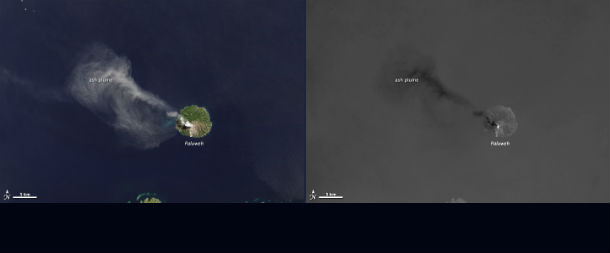
While the Landsat Data Continuity Mission (LDCM) flew over Indonesia’s Flores Sea on April 29, 2013, the satellite’s Operational Land Imager (OLI) took a natural-color photo of Paluweh volcano pluming ash.The Thermal Infrared Sensor (TIRS) on LDCM got an alternate view of the very same occurrence.
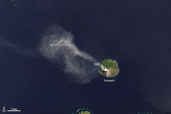
The natural-color image of Paluweh volcano pluming acquired by Operational Land Imager (OLI) on April 29, 2013 (Credit: Robert Simmon, using data from the U.S. Geological Survey and NASA. Caption by Kate Ramsayer and Mike Carlowicz)
During an observation of the heat produced by the five-mile-wide volcanic island, TIRS uncovered a hot spot where lava was exuding near the top of the volcano. The thermal sensor also displayed the coolness of the ash in contrast with the warmth of the tropical ocean surface beneath, with the darker tone of the plume representing cooler temperatures.

Different view of the same event captured by TIRS on April 29, 2013 ((Credit: Robert Simmon, using data from the U.S. Geological Survey and NASA. Caption by Kate Ramsayer and Mike Carlowicz)
Betsy Forsbacka, TIRS instrument manager at NASA’s Goddard Space Flight Center, referring to the combination of the two LCDM instruments, said that each instrument by itself is magnificent, but when you put them together, with the clues that each give you about Earth’s surface, it’s greater than either could do by themselves.
The LDCM team is very enthusiastic about TIRS because of its ability to capture the sharp boundary between hot lava and cooler volcanic ash without the signal from the hot spot oozing over into pixels of the cooler areas.The thermal sensors engineers tested and refined the instrument prior to launch to make sure that each pixel accurately represents the heat source it images.Otherwise looking at hot spots would be like shining a flashlight in your eyes; the bright light makes you see spots and halos where it should be dark, Forsbacka explained.Similar effect can happen with satellite detectors.
Moreover TIRS has the ability to detect fine shifts in temperature, even within a tenth of a degree Celsius.
For experts it should be easier to acquire a more precise temperature of Earths surface with LDCM having two different thermal bands (instead of one, like previous Landsat sensors).Monitoring land surface temperatures from space can be a difficult task, because moisture and particles in the atmosphere can slightly change thermal signals.With TIRS, the atmosphere affects each thermal band in a slightly different fashion, creating one thermal image that’s a tiny bit darker than the other. By measuring that difference and plugging it into image-analysis algorithms, experts are able to better attend to atmospheric effects and produce a more precise temperature record of the Earth’s surface.
Source: Earth Observatory
Commenting rules and guidelines
We value the thoughts and opinions of our readers and welcome healthy discussions on our website. In order to maintain a respectful and positive community, we ask that all commenters follow these rules.