
Active volcanoes in the world: May 1 – May 7, 2013
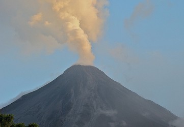
Image credit: Steve Jurvetson – CC BY 2.0
This week, 5 volcanoes had new activity, whereas ongoing activity was reported for 11 volcanoes. This report covers active volcanoes in the world recorded from May 1 – May 7, 2013 based on Smithsonian/USGS criteria.
New activity/unrest: | Cleveland, Chuginadak Island | Heard, Southern Indian Ocean | Mayon, Luzon |Papandayan, Western Java (Indonesia) | Tungurahua, Ecuador
Ongoing activity: | Bagana, Bougainville | Batu Tara, Komba Island (Indonesia) | Karymsky, Eastern Kamchatka (Russia) | Kilauea, Hawaii (USA) | Kizimen, Eastern Kamchatka (Russia) | Paluweh, Lesser Sunda Islands (Indonesia) | Reventador, Ecuador | Sakura-jima, Kyushu | Shiveluch, Central Kamchatka (Russia) | Soufrière Hills, Montserrat | Tolbachik, Central Kamchatka (Russia)
The Weekly Volcanic Activity Report is a cooperative project between the Smithsonian’s Global Volcanism Program and the US Geological Survey’s Volcano Hazards Program. Updated by 2300 UTC every Wednesday, notices of volcanic activity posted on these pages are preliminary and subject to change as events are studied in more detail. This is not a comprehensive list of all of Earth’s volcanoes erupting during the week, but rather a summary of activity at volcanoes that meet criteria discussed in detail in the “Criteria and Disclaimers” section. Carefully reviewed, detailed reports on various volcanoes are published monthly in the Bulletin of the Global Volcanism Network.
New activity/unrest
CLEVELAND, Chuginadak Island
52.825°N, 169.944°W; summit elev. 1730 m
AVO reported that on 4 May the infrasound network detected three short-duration explosions from Cleveland at 0500, 0717, and 1144. A small, low-altitude ash cloud along with high surface temperatures at the summit were observed in satellite images starting at 0717. In a report posted at 1822 AVO noted that both webcam and satellite images suggested continuous low-level emissions of gas, steam, and minor amounts of ash over the past several hours with a faint plume drifting E below 4.6 km (15,000 ft) a.s.l. The Volcanic Alert Level was raised to Watch and the Aviation Color Code was raised to Orange.
On 5 May the amplitude of the Cleveland infrasonic tremor, as measured by the ground-coupled airwaves on the Okmok seismic network, 120 km NE, decreased from its peak activity the evening before. Satellite images again detected continuous low-level emissions of gas, steam, and minor amounts of ash producing a faint plume that drifted E below 4.6 km (15,000 ft) a.s.l. Explosions were detected at 1123 on 5 May and 0800 on 6 May. A thermal anomaly continued to be detected. A news article stated that some airplanes were diverted away from Cleveland.
Geologic summary: Symmetrical Mount Cleveland stratovolcano is situated at the western end of the uninhabited dumbbell-shaped Chuginadak Island in the east-central Aleutians. The 1,730-m-high stratovolcano is the highest of the Islands of Four Mountains group and is one of the most active in the Aleutians. Numerous large lava flows descend its flanks. It is possible that some 18th to 19th century eruptions attributed to Carlisle (a volcano located across the Carlisle Pass Strait to the NW) should be ascribed to Cleveland. In 1944 Cleveland produced the only known fatality from an Aleutian eruption. Recent eruptions from Mt. Cleveland have been characterized by short-lived explosive ash emissions, at times accompanied by lava fountaining and lava flows down the flanks.
HEARD, Southern Indian Ocean
53.106°S, 73.513°E; summit elev. 2745 m
According to NASA Earth Observatory (EO) an image acquired on 7 April from the Advanced Land Imager (ALI) on NASA’s EO-1 satellite showed that Mawson’s Peak crater on Heard Island had filled and a lava flow had traveled down the SW flank. The lava flow was visible in an image acquired on 20 April and had slightly widened just below the summit.
Geologic summary: Heard Island on the Kerguelen Plateau in the southern Indian Ocean consists primarily of the emergent portion of two volcanic structures. The large glacier-covered composite basaltic-to-trachytic cone of Big Ben comprises most of the island, and the smaller Mt. Dixon volcano lies at the NW tip of the island across a narrow isthmus. Little is known about the structure of Big Ben volcano because of its extensive ice cover. The historically active Mawson Peak forms the island’s 2745-m high point and lies within a 5-6 km wide caldera breached to the SW side of Big Ben. Small satellitic scoria cones are mostly located on the northern coast. Several subglacial eruptions have been reported in historical time at this isolated volcano, but observations are infrequent and additional activity may have occurred.
MAYON, Luzon
13.257°N, 123.685°E; summit elev. 2462 m
PHIVOLCS reported that a small phreatic eruption from Mayon occurred at 0800 on 7 May and lasted for 2 minutes and 26 seconds. A gray-to-brown ash cloud rose 500 m above the crater and drifted WSW. Ash fell in areas WNW, affecting the barangays of Muladbucad (10 km WSW), Guinobatan (11 km SW), Nabonton (10 km W), Nasisi (11 km W), Basag (10 km W), Tambo, Ligao City (19 km WSW), Albay (19 km SW), and areas upslope of these barangays. One rockfall was detected. Seismicity and gas emissions remained within background levels and indicated no intensification of activity. The Alert Level remained at 0 and the public was reminded not to enter the 6-km-radius Permanent Danger Zone (PDZ).
According to a news article, the eruption ejected large “room-sized rocks” towards about 30 climbers, killing five and injuring eight.
Geologic summary: Beautifully symmetrical Mayon volcano, which rises to 2,462 m above the Albay Gulf, is the Philippines’ most active volcano. The structurally simple volcano has steep upper slopes that average 35-40° and is capped by a small summit crater. The historical eruptions of this basaltic-andesitic volcano date back to 1616 and range from Strombolian to basaltic Plinian. Eruptions occur predominately from the central conduit and have also produced lava flows that travel far down the flanks. Pyroclastic flows and mudflows have commonly swept down many of the approximately 40 ravines that radiate from the summit and have often devastated populated lowland areas. Mayon’s most violent eruption, in 1814, killed more than 1,200 people and devastated several towns. Eruptions that began in February 2000 led PHIVOLCS to recommend on 23 February 2000 the evacuation of people within a radius of 7 km from the summit in the SE and within a 6 km radius for the rest of the volcano.
PAPANDAYAN, Western Java (Indonesia)
7.32°S, 107.73°E; summit elev. 2665 m
CVGHM reported that during 1 April-5 May soil temperatures around Papandayan’s crater fluctuated but increased overall. During 1-5 May seismicity increased, prompting CVGHM to raise the Alert level to 3 (on a scale of 1-4) on 5 May. Tourists and residents were reminded not to venture within 2 km of the active crater.
Geologic summary: Papandayan is a complex stratovolcano with four large summit craters, the youngest of which was breached to the NE by collapse during a brief eruption in 1772 and contains active fumarole fields. The broad 1.1-km-wide, flat-floored Alun-Alun crater truncates the summit of Papandayan, and Gunung Puntang to the N gives the volcano a twin-peaked appearance. Several episodes of collapse have given the volcano an irregular profile and produced debris avalanches that have impacted lowland areas beyond the volcano. Since its first historical eruption in 1772, in which a catastrophic debris avalanche destroyed 40 villages, only two small phreatic eruptions have occurred from vents in the NE-flank fumarole field, Kawah Mas.
TUNGURAHUA, Ecuador
1.467°S, 78.442°W; summit elev. 5023 m
IG reported that although cloud cover often prevented observations of Tungurahua during 1-7 May ash plumes were observed almost daily. Seismicity remained at a moderate level, although it increased on 4 May.
On 1 May an explosion and rolling blocks were heard, and ashfall was reported in El Manzano (8 km SW). The next day steam-and-ash plumes rose 1-1.5 km above the crater and drifted W. Ashfall was reported in Cevallos (23 km NW), Tisaleo (29 km NW), Quero (20 km NW), and Mocha (25 km WNW). During 2-4 May Strombolian activity was observed at night. On 3 May several explosions produced ash plumes that rose 2-3 km above the crater and drifted N and NW. Ash fell in Juive (7 km NNW), Runtún (6 km NNE), Pondoa 8 km N), Baños (8 km N), Patate (NW), Pelileo (8 km N), Ambato (31 km NW), Cevallos, and at the Tungurahua Observatory (OVT) in Guadalupe (14 km N). On 4 May explosions rattled windows in Baños, and ash plumes rose 1-1.5 km and drifted N and NW. Large lahars traveled down the La Pampa drainage on the S flank, while other lahars traveled down the Vazcún, Juive, and Mandur drainages on the N and NW flanks. Explosions on 5 May rattled windows in Ventanas, Pondoa, and Runtún. An ash plume rose 2 km and drifted W. Ashfall was again reported in Cevallos, Tisaleo, Quero, and Mocha. A pyroclastic flow descended the NW flank 2 km. On 6 May ash plumes drifted SW and ashfall was reported in Cevallos, Tisaleo, Quero, Mocha, Pillate (8 km W), Choglontus (SW), and El Manzano. The next day ash plumes rose 3 km and drifted SW. Ashfall was reported in Sabañag (15 km WNW), Chazo, Ilapo, and Riobamba (30 km S).
Geologic summary: The steep-sided Tungurahua stratovolcano towers more than 3 km above its northern base. It sits ~140 km S of Quito, Ecuador’s capital city, and is one of Ecuador’s most active volcanoes. Historical eruptions have all originated from the summit crater. They have been accompanied by strong explosions and sometimes by pyroclastic flows and lava flows that reached populated areas at the volcano’s base. The last major eruption took place from 1916 to 1918, although minor activity continued until 1925. The latest eruption began in October 1999 and prompted temporary evacuation of the town of Baños on the N side of the volcano.
Ongoing activity
BAGANA, Bougainville
6.140°S, 155.195°E; summit elev. 1750 m
Based on analyses of satellite imagery and wind data, the Darwin VAAC reported that during 5-6 May ash plumes from Bagana rose to an altitude of 2.1 km (7,000 ft) a.s.l. and drifted 75-85 km W.
Geologic summary: Bagana volcano, occupying a remote portion of central Bougainville Island, is one of Melanesia’s youngest and most active volcanoes. Bagana is a massive symmetrical lava cone largely constructed by an accumulation of viscous andesitic lava flows. The entire lava cone could have been constructed in about 300 years at its present rate of lava production. Eruptive activity at Bagana is characterized by non-explosive effusion of viscous lava that maintains a small lava dome in the summit crater, although explosive activity occasionally producing pyroclastic flows also occurs. Lava flows form dramatic, freshly preserved tongue-shaped lobes up to 50-m-thick with prominent levees that descend the volcano’s flanks on all sides.
BATU TARA, Komba Island (Indonesia)
7.792°S, 123.579°E; summit elev. 748 m
Based on analyses of satellite imagery and wind data, the Darwin Volcanic Ash Advisory Centre (VAAC) reported that during 1 and 6-7 May ash plumes from Batu Tara rose to an altitude of 2.1 km (7,000 ft) a.s.l. and drifted 45-55 km NW and W.
Geologic summary: The small isolated island of Batu Tara in the Flores Sea about 50 km north of Lembata (formerly Lomblen) Island contains a scarp on the eastern side similar to the Sciara del Fuoco of Italy’s Stromboli volcano. Vegetation covers the flanks of Batu Tara to within 50 m of the 748-m-high summit. Batu Tara lies north of the main volcanic arc and is noted for its potassic leucite-bearing basanitic and tephritic rocks. The first historical eruption from Batu Tara, during 1847-52, produced explosions and a lava flow.
KARYMSKY, Eastern Kamchatka (Russia)
54.05°N, 159.45°E; summit elev. 1536 m
KVERT reported that satellite data showed a thermal anomaly on Karymsky on 26 April. Two streaks of ash deposits near the volcano were observed during 1-2 May: about 15 km to the W and about 30 km to the NW of the volcano. Technical problems prevented seismic data collection during 26 April-3 May. The Aviation Color Code remained at Orange.
Geologic summary: Karymsky, the most active volcano of Kamchatka’s eastern volcanic zone, is a symmetrical stratovolcano constructed within a 5-km-wide caldera that formed about 7,600-7,700 radiocarbon years ago. Construction of the Karymsky stratovolcano began about 2,000 years later. The latest eruptive period began about 500 years ago, following a 2,300-year quiescence. Much of the cone is mantled by lava flows less than 200 years old. Historical eruptions have been Vulcanian or Vulcanian-Strombolian with moderate explosive activity and occasional lava flows from the summit crater. Most seismicity preceding Karymsky eruptions has originated beneath Akademia Nauk caldera, which is located immediately S of Karymsky volcano and erupted simultaneously with Karymsky in 1996.
KILAUEA, Hawaii (USA)
19.421°N, 155.287°W; summit elev. 1222 m
During 1-7 May HVO reported that the circulating lava lake occasionally rose and fell in the deep pit within Kilauea’s Halema’uma’u Crater. The plume from the vent continued to deposit variable amounts of ash, spatter, and Pele’s hair onto nearby areas.
At Pu’u ‘O’o Crater, glow emanated from three spatter cones and a small lava pond on the E part of the crater floor. Small lava flows issued from the N spatter cone on 1 May and from the SW cone on 2 May. The lava pond overflowed during 3-4 and 6-7 May.
Peace Day activity, fed by lava tubes extending from Pu’u ‘O’o, consisted of lava flows active above the pali SE of Pu’u ‘O’o, on the pali, and on the coastal plain. Lava also entered the ocean in at least two locations spanning the National Park boundary. On 3 May a breakout on the top of the pali produced a lava flow that traveled down to the coastal plain in about 1 hour. Branches from the flow advanced during 4-6 May.
Geologic summary: Kilauea, one of five coalescing volcanoes that comprise the island of Hawaii, is one of the world’s most active volcanoes. Eruptions at Kilauea originate primarily from the summit caldera or along one of the lengthy E and SW rift zones that extend from the caldera to the sea. About 90% of the surface of Kilauea is formed of lava flows less than about 1,100 years old; 70% of the volcano’s surface is younger than 600 years. A long-term eruption from the East rift zone that began in 1983 has produced lava flows covering more than 100 sq km, destroying nearly 200 houses and adding new coastline to the island.
KIZIMEN, Eastern Kamchatka (Russia)
55.130°N, 160.32°E; summit elev. 2376 m
KVERT reported that during 26 May-3 April moderate seismic activity continued at Kizimen. Video and satellite data showed that lava continued to extrude from the summit, producing incandescence, strong gas-and-steam activity, and hot avalanches on the W and E flanks. A thermal anomaly was detected daily in satellite images. The Aviation Color Code remained at Orange.
Geologic summary: Kizimen is an isolated, conical stratovolcano that is morphologically similar to Mount St. Helens prior to its 1980 eruption. The summit of Kizimen consists of overlapping lava domes, and blocky lava flows descend the flanks of the volcano, which is the westernmost of a volcanic chain north of Kronotsky volcano. The 2,376-m-high Kizimen was formed during four eruptive cycles beginning about 12,000 years ago and lasting 2,000-3,500 years. The largest eruptions took place about 10,000 and 8300-8400 years ago, and three periods of longterm lava-dome growth have occurred. The latest eruptive cycle began about 3,000 years ago with a large explosion and was followed by lava-dome growth lasting intermittently about 1,000 years. An explosive eruption about 1,100 years ago produced a lateral blast and created a 1.0 x 0.7 km wide crater breached to the NE, inside which a small lava dome (the fourth at Kizimen) has grown. A single explosive eruption, during 1927-28, has been recorded in historical time.
PALUWEH, Lesser Sunda Islands (Indonesia)
8.32°S, 121.708°E; summit elev. 875 m
Based on analyses of satellite imagery and wind data, the Darwin VAAC reported that during 4-5 May ash plumes from Paluweh rose to an altitude of 2.1 km (7,000 ft) a.s.l. and drifted 45-55 km SW and W.
Geologic summary: Paluweh volcano, also known as Rokatenda, forms the 8-km-wide island of Paluweh N of the volcanic arc that cuts across Flores Island. Although the volcano rises about 3,000 m above the sea floor, its summit reaches only 875 m above sea level. The broad irregular summit region contains overlapping craters up to 900 m wide and several lava domes. Several flank vents occur along a NW-trending fissure. The largest historical eruption of Paluweh occurred in 1928, when a strong explosive eruption was accompanied by landslide-induced tsunamis and lava-dome emplacement.
REVENTADOR, Ecuador
0.077°S, 77.656°W; summit elev. 3562 m
According to the Washington VAAC, IG reported that on 1 May seismicity at Reventador was elevated, and an ash plume rose to an altitude of 7 km (23,000 ft) a.s.l. A thermal anomaly was visible in satellite images. On 2 May ash was not identified in images and seismicity decreased.
Geologic summary: Reventador is the most frequently active of a chain of Ecuadorian volcanoes in the Cordillera Real, well E of the principal volcanic axis. It is a forested stratovolcano that rises above the remote jungles of the western Amazon basin. A 3-km-wide caldera breached to the E was formed by edifice collapse and is partially filled by a young, unvegetated stratovolcano that rises about 1,300 m above the caldera floor. Reventador has been the source of numerous lava flows as well as explosive eruptions that were visible from Quito in historical time. Frequent lahars in this region of heavy rainfall have constructed a debris plain on the eastern floor of the caldera.
SAKURA-JIMA, Kyushu
31.585°N, 130.657°E; summit elev. 1117 m
Based on information from JMA, the Tokyo VAAC reported that during 1-6 April explosions from Sakura-jima generated ash plumes that rose to altitudes of 1.8-3 km (6,000-10,000 ft) a.s.l. and drifted E and SE. A pilot observed an ash plume that rose to an altitude of 2.4 km (8,000 ft) a.s.l. on 3 April. Another ash plume observed by a pilot rose to an altitude of 3.4 km (11,000 ft) a.s.l. and drifted S on 5 May.
Geologic summary: Sakura-jima, one of Japan’s most active volcanoes, is a post-caldera cone of the Aira caldera at the northern half of Kagoshima Bay. Eruption of the voluminous Ito pyroclastic flow was associated with the formation of the 17 x 23-km-wide Aira caldera about 22,000 years ago. The construction of Sakura-jima began about 13,000 years ago and built an island that was finally joined to the Osumi Peninsula during the major explosive and effusive eruption of 1914. Activity at the Kita-dake summit cone ended about 4,850 years ago, after which eruptions took place at Minami-dake. Frequent historical eruptions, recorded since the 8th century, have deposited ash on Kagoshima, one of Kyushu’s largest cities, located across Kagoshima Bay only 8 km from the summit. The largest historical eruption took place during 1471-76.
SHIVELUCH, Central Kamchatka (Russia)
56.653°N, 161.360°E; summit elev. 3283 m
Based on visual observations and analyses of satellite data, KVERT reported that during 26 April-3 May a viscous lava flow effused on the NW and NE flanks of Shiveluch’s lava dome, accompanied by hot avalanches, incandescence, and fumarolic activity. Satellite imagery showed a daily thermal anomaly on the lava dome. The Aviation Color Code remained at Orange.
Based on analyses of satellite imagery and notices from Yelizovo Airport (UHPP), the Tokyo VAAC reported that on 5 May an ash plume rose to an altitude of 4.6 km (15,000 ft) a.s.l. and drifted E.
Geologic summary: The high, isolated massif of Shiveluch volcano (also spelled Sheveluch) rises above the lowlands NNE of the Kliuchevskaya volcano group and forms one of Kamchatka’s largest and most active volcanoes. The currently active Molodoy Shiveluch lava-dome complex was constructed during the Holocene within a large breached caldera formed by collapse of the massive late-Pleistocene Strary Shiveluch volcano. At least 60 large eruptions of Shiveluch have occurred during the Holocene, making it the most vigorous andesitic volcano of the Kuril-Kamchatka arc. Frequent collapses of lava-dome complexes, most recently in 1964, have produced large debris avalanches whose deposits cover much of the floor of the breached caldera. Intermittent explosive eruptions began in the 1990s from a new lava dome that began growing in 1980. The largest historical eruptions from Shiveluch occurred in 1854 and 1964.
SOUFRIERE HILLS, Montserrat
16.72°N, 62.18°W; summit elev. 915 m
MVO reported that during 26 April-3 May activity at the Soufrière Hills lava dome was at a low level. During 1-2 May the wind direction shifted to the N and NE, blowing the plume over inhabited areas where residents occasionally reported volcanic-gas odors. The Hazard Level remained at 2 (on a scale of 1-5).
Geologic summary: The complex dominantly andesitic Soufrière Hills volcano occupies the southern half of the island of Montserrat. The summit area consists primarily of a series of lava domes emplaced along an ESE-trending zone. English’s Crater, a 1-km-wide crater breached widely to the E, was formed during an eruption about 4,000 years ago in which the summit collapsed, producing a large submarine debris avalanche. Block-and-ash flow and surge deposits associated with dome growth predominate in flank deposits at Soufrière Hills. Non-eruptive seismic swarms occurred at 30-year intervals in the 20th century, but with the exception of a 17th-century eruption that produced the Castle Peak lava dome, no historical eruptions were recorded on Montserrat until 1995. Long-term small-to-moderate ash eruptions beginning in that year were later accompanied by lava-dome growth and pyroclastic flows that forced evacuation of the southern half of the island and ultimately destroyed the capital city of Plymouth, causing major social and economic disruption.
TOLBACHIK, Central Kamchatka (Russia)
55.830°N, 160.330°E; summit elev. 3682 m
KVERT reported that the S fissure along the W side of Tolbachinsky Dol, a lava plateau on the SW side of Tolbachik, continued to produce very fluid lava flows during 26 April-3 May that traveled to the W, S, and E sides of the plateau. Cinder cones continued to grow along the S fissure and gas-and-ash plumes were observed. A large thermal anomaly on the N part of Tolbachinsky Dol was visible daily in satellite imagery. The Aviation Color Code remained at Orange.
Geologic summary: The massive Tolbachik basaltic volcano is located at the southern end of the dominantly andesitic Kliuchevskaya volcano group. The Tolbachik massif is composed of two overlapping, but morphologically dissimilar volcanoes. The flat-topped Plosky Tolbachik shield volcano with its nested Holocene Hawaiian-type calderas up to 3 km in diameter is located east of the older and higher sharp-topped Ostry Tolbachik stratovolcano. The summit caldera at Plosky Tolbachik was formed in association with major lava effusion about 6500 years ago and simultaneously with a major southward-directed sector collapse of Ostry Tolbachik volcano. Lengthy rift zones extending NE and SSW of the volcano have erupted voluminous basaltic lava flows during the Holocene, with activity during the past two thousand years being confined to the narrow axial zone of the rifts. The 1975-76 eruption originating from the SSW-flank fissure system and the summit was the largest historical basaltic eruption in Kamchatka.
Source: Global Volcanism Program
Commenting rules and guidelines
We value the thoughts and opinions of our readers and welcome healthy discussions on our website. In order to maintain a respectful and positive community, we ask that all commenters follow these rules.