
6.4 magnitude earthquake struck Vanuatu
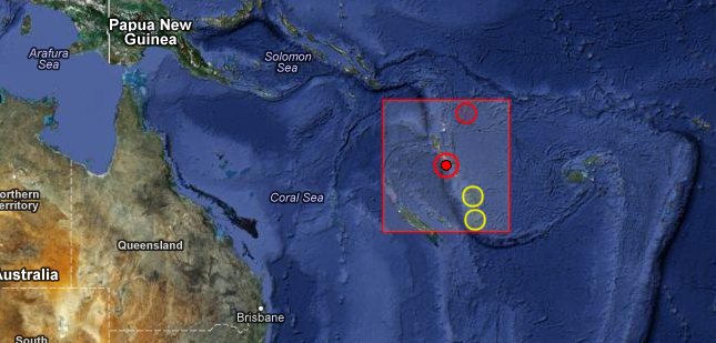
Image credit: EMSC + Google Earth
6.4 magnitude earthquake struck Vanuatu at 00:54 UTC on December 2, 2012 according to USGS and EMSC. Epicenter was located 101 km (62 miles) SSE of Lakatoro, Vanuatu and 108 km (67 miles) NW of Port-Vila, Vanuatu at coordinates 17.012°S, 167.626°E. Recorded depth by USGS was 34.1 km (21.2 miles) and 29 km by EMSC. GDACS said that this earthquake can have a low humanitarian impact based on the magnitude and the affected population and their vulnerability. About 50000 people are living within 100 km.
| Magnitude | 6.4 |
|---|---|
| Date-Time |
|
| Location | 17.012°S, 167.626°E |
| Depth | 34.1 km (21.2 miles) |
| Region | VANUATU |
| Distances | 101 km (62 miles) SSE of Lakatoro, Vanuatu 108 km (67 miles) NW of Port-Vila, Vanuatu 170 km (105 miles) SSE of Luganville, Vanuatu 434 km (269 miles) N of We, New Caledonia |
| Location Uncertainty | horizontal +/- 14.4 km (8.9 miles); depth +/- 7 km (4.3 miles) |
| Parameters | NST=291, Nph=297, Dmin=573.3 km, Rmss=0.65 sec, Gp= 32°, M-type=regional moment magnitude (Mw), Version=9 |
| Source |
|
| Event ID | usc000e26u |

Tectonic summary by USGS
Seismotectonics of the Eastern Margin of the Australia Plate
The eastern margin of the Australia plate is one of the most sesimically active areas of the world due to high rates of convergence between the Australia and Pacific plates. In the region of New Zealand, the 3000 km long Australia-Pacific plate boundary extends from south of Macquarie Island to the southern Kermadec Island chain. It includes an oceanic transform (the Macquarie Ridge), two oppositely verging subduction zones (Puysegur and Hikurangi), and a transpressive continental transform, the Alpine Fault through South Island, New Zealand.
Since 1900 there have been 15 M7.5+ earthquakes recorded near New Zealand. Nine of these, and the four largest, occurred along or near the Macquarie Ridge, including the 1989 M8.2 event on the ridge itself, and the 2004 M8.1 event 200 km to the west of the plate boundary, reflecting intraplate deformation. The largest recorded earthquake in New Zealand itself was the 1931 M7.8 Hawke’s Bay earthquake, which killed 256 people. The last M7.5+ earthquake along the Alpine Fault was 170 years ago; studies of the faults’ strain accumulation suggest that similar events are likely to occur again.
North of New Zealand, the Australia-Pacific boundary stretches east of Tonga and Fiji to 250 km south of Samoa. For 2,200 km the trench is approximately linear, and includes two segments where old (>120 Myr) Pacific oceanic lithosphere rapidly subducts westward (Kermadec and Tonga). At the northern end of the Tonga trench, the boundary curves sharply westward and changes along a 700 km-long segment from trench-normal subduction, to oblique subduction, to a left lateral transform-like structure.
Australia-Pacific convergence rates increase northward from 60 mm/yr at the southern Kermadec trench to 90 mm/yr at the northern Tonga trench; however, significant back arc extension (or equivalently, slab rollback) causes the consumption rate of subducting Pacific lithosphere to be much faster. The spreading rate in the Havre trough, west of the Kermadec trench, increases northward from 8 to 20 mm/yr. The southern tip of this spreading center is propagating into the North Island of New Zealand, rifting it apart. In the southern Lau Basin, west of the Tonga trench, the spreading rate increases northward from 60 to 90 mm/yr, and in the northern Lau Basin, multiple spreading centers result in an extension rate as high as 160 mm/yr. The overall subduction velocity of the Pacific plate is the vector sum of Australia-Pacific velocity and back arc spreading velocity: thus it increases northward along the Kermadec trench from 70 to 100 mm/yr, and along the Tonga trench from 150 to 240 mm/yr. (Read the rest here)
List of worldwide earthquakes following M 6.4 Vanuatu
Update time: Sunday, December 2, 2012 11:07:21 UTC (Source: USGS)
| MAG | UTC DATE-TIME y/m/d h:m:s | LAT deg | LON deg | DEPTH km | Region |
|---|---|---|---|---|---|
| 3.7 | 2012/12/02 10:20:35 | 36.093 | -117.843 | 3.1 | CENTRAL CALIFORNIA |
| 2.5 | 2012/12/02 10:16:26 | 36.305 | -120.867 | 0.2 | CENTRAL CALIFORNIA |
| 2.6 | 2012/12/02 08:24:03 | 36.830 | -121.561 | 5.5 | CENTRAL CALIFORNIA |
| 3.6 | 2012/12/02 08:09:51 | 18.819 | -65.438 | 46.0 | PUERTO RICO REGION |
| 3.9 | 2012/12/02 07:53:50 | 19.112 | -68.906 | 124.0 | DOMINICAN REPUBLIC REGION |
| 2.5 | 2012/12/02 07:48:22 | 36.083 | -117.851 | 0.3 | CENTRAL CALIFORNIA |
| 4.3 | 2012/12/02 07:37:06 | -31.138 | -71.335 | 57.4 | COQUIMBO, CHILE |
| 3.2 | 2012/12/02 06:37:08 | 51.584 | -176.537 | 58.2 | ANDREANOF ISLANDS, ALEUTIAN IS., ALASKA |
| 2.9 | 2012/12/02 05:51:04 | 51.486 | -178.072 | 6.6 | ANDREANOF ISLANDS, ALEUTIAN IS., ALASKA |
| 5.1 | 2012/12/02 04:44:38 | 11.816 | -89.006 | 50.9 | OFF THE COAST OF CENTRAL AMERICA |
| 4.3 | 2012/12/02 03:02:02 | 27.822 | 139.855 | 503.6 | BONIN ISLANDS, JAPAN REGION |
| 2.8 | 2012/12/02 02:10:46 | 20.134 | -155.616 | 34.3 | HAWAII REGION, HAWAII |
| 2.6 | 2012/12/02 01:59:58 | 33.277 | -115.641 | 0.5 | SOUTHERN CALIFORNIA |
| 6.4 | 2012/12/02 00:54:23 | -17.012 | 167.626 | 34.1 | VANUATU |
I'm a dedicated researcher, journalist, and editor at The Watchers. With over 20 years of experience in the media industry, I specialize in hard science news, focusing on extreme weather, seismic and volcanic activity, space weather, and astronomy, including near-Earth objects and planetary defense strategies. You can reach me at teo /at/ watchers.news.
Commenting rules and guidelines
We value the thoughts and opinions of our readers and welcome healthy discussions on our website. In order to maintain a respectful and positive community, we ask that all commenters follow these rules.