
Magnitude 6.4 earthquake struck Gulf of Alaska
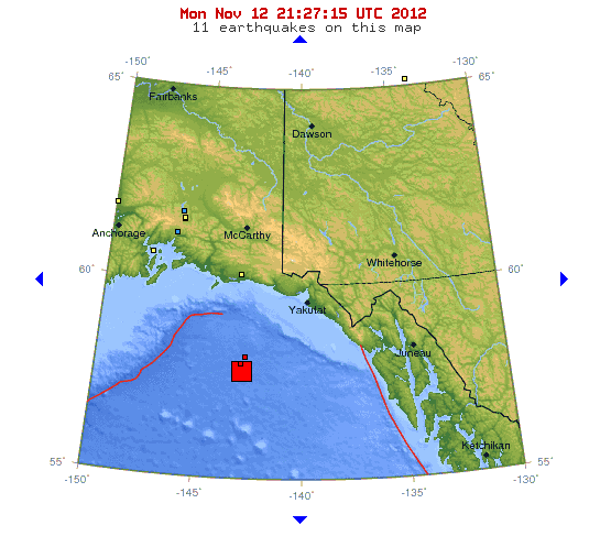
Image credit: USGS
Strong earthquake with recorded magnitude 6.4 struck Gulf of Alaska on November 12, 2012 at 20:42 UTC according to USGS. Epicenter was located 289 km (180 miles) SW (221°) from Yakutat, AK and 370 km (230 miles) SSE (153°) from Cordova, AK at coordinates 57.544°N, 142.889°W. Recorded depth was 55.2 km (34.3 miles). EMSC also reported magnitude 6.4 but depth of only 2 km.
No tsunami warning was issued.
| Magnitude | 6.4 |
|---|---|
| Date-Time |
|
| Location | 57.544°N, 142.889°W |
| Depth | 55.2 km (34.3 miles) |
| Region | GULF OF ALASKA |
| Distances |
|
| Location Uncertainty | horizontal +/- 2.7 km (1.7 miles); depth +/- 11.3 km (7.0 miles) |
| Parameters | NST= 46, Nph= 49, Dmin=285.6 km, Rmss=0.47 sec, Gp=220°, M-type=body wave magnitude (Mb), Version=2 |
| Source |
|
| Event ID | ak10598710 |

Tectonic summary by USGS
Seismotectonics of the Aleutian Arc
The Aleutian arc extends approximately 3,000 km from the Gulf of Alaska in the east to the Kamchatka Peninsula in the west. It marks the region where the Pacific plate subducts into the mantle beneath the North America plate. This subduction is responsible for the generation of the Aleutian Islands and the deep offshore Aleutian Trench.
The curvature of the arc results in a westward transition of relative plate motion from trench-normal (i.e., compressional) in the east to trench-parallel (i.e., translational) in the west, accompanied by westward variations in seismic activity, volcanism, and overriding plate composition. The Aleutian arc is generally divided into three regions: the western, central, and eastern Aleutians. Relative to a fixed North America plate, the Pacific plate is moving northwest at a rate that increases from roughly 60 mm/yr at the arc’s eastern edge to 76 mm/yr near its western terminus. The eastern Aleutian arc extends from the Alaskan Peninsula in the east to the Fox Islands in the west. Motion along this section of the arc is characterized by arc-perpendicular convergence and Pacific plate subduction beneath thick continental lithosphere. This region exhibits intense volcanic activity and has a history of megathrust earthquakes… read more on Aleutian Arc here.
I'm a dedicated researcher, journalist, and editor at The Watchers. With over 20 years of experience in the media industry, I specialize in hard science news, focusing on extreme weather, seismic and volcanic activity, space weather, and astronomy, including near-Earth objects and planetary defense strategies. You can reach me at teo /at/ watchers.news.
Commenting rules and guidelines
We value the thoughts and opinions of our readers and welcome healthy discussions on our website. In order to maintain a respectful and positive community, we ask that all commenters follow these rules.