
Typhoon Son-Tinh – Red alert for wind impact in Vietnam, China
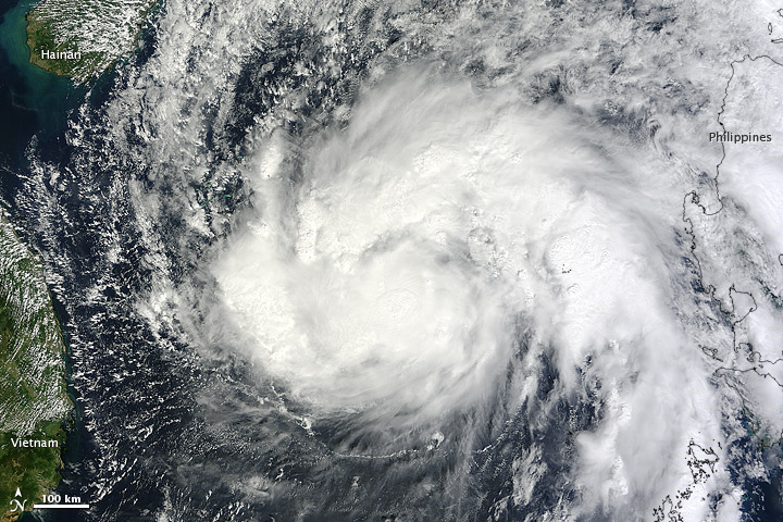
Featured image: Tropical Storm Son-Tinh blew over the South China Sea, midway between the Philippines and Vietnam, on October 26, 2012. The Moderate Resolution Imaging Spectroradiometer (MODIS) on NASA’s Terra satellite took this picture the same day. Although Son-tinh did not boast a distinct eye, it still had the apostrophe shape typical of a strong storm.
Up to 5.5 million people people can be affected by wind speeds of cyclone strength or above. In addition, 3.2 million people people are living in coastal areas below 5m and can therefore be affected by storm surge.
Typhoon Son-Tinh struck Vietnam at about 0:00 UTC on October 28, 2012. Data supplied by the US Navy and Air Force Joint Typhoon Warning Center suggest that the point of landfall was near 19.6 N,106.9 E. Son-Tinh brought 1-minute maximum sustained winds to the region of around 185 km/h (114 mph). Wind gusts in the area may have been considerably higher.

Son-Tinh formed as a tropical depression over the western Pacific Ocean on October 23 and strengthened into a storm the next day. On October 26, the U.S. Navy’s Joint Typhoon Warning Center (JTWC) reported that Son-Tinh was located about 355 nautical miles (655 kilometers) east of Hue, Vietnam. The storm had maximum sustained winds of 60 knots (110 kilometers per hour) and gusts up to 75 knots (140 kilometers per hour). Son-Tinh was expected to gain strength over the next 24 hours, and the JTWC projected storm track showed the storm moving toward the northwest, making landfall in Vietnam.
According to the Saffir-Simpson damage scale the potential property damage and flooding from a storm of Son-Tinh’s strength (category 3) at landfall includes:
- Storm surge generally 2.7-3.7 metres (9-12 feet) above normal.
- Some structural damage to small residences and utility buildings with a minor amount of curtainwall failures.
- Damage to shrubbery and trees with foliage blown off trees and large trees blown down.
- Mobile homes and poorly constructed signs are destroyed.
- Low-lying escape routes are cut by rising water 3-5 hours before arrival of the centre of the storm.
- Flooding near the coast destroys smaller structures with larger structures damaged by battering from floating debris.
- Terrain continuously lower than 1.5 metres (5 feet) above mean sea level may be flooded inland 13 km (8 miles) or more.
- Evacuation of low-lying residences within several blocks of the shoreline may be required.
There is also the potential for flooding further inland due to heavy rain.
GDACS reported that Tropical Cyclone SON-TINH-12 can have a high humanitarian impact based on the Maximum sustained wind speed and the affected population and their vulnerability.
Updated: this report is based on advisory number 20.
- Tropical Cyclone Hurricane/Typhoon > 74 mph (maximum wind speed of 204 km/h)
- from 24/10/2012 00:00 UTC to 28/10/2012 12:00 UTC
- Population affected by Category 1 (120 km/h) wind speeds or higher is 5.5million
- Vulnerability: High
Storm surge
The maximum Storm surge height is 2.3m in Dai Loc, Vietnam. This height is estimated for 28 Oct 2012 17:00:00.
5 missing after Typhoon Son-Tinh sinks boat in South China Sea
Xinhua reported that five people were missing after Typhoon Son-Tinh sank their boat in the South China Sea near the city of Sanya on Sunday, maritime authorities said.
Local sea rescue center in Sanya, Hainan Province, received a report at about 6 a.m. saying an unpowered engineering vessel half-sanked near a cargo terminal of Sanya after being hit by strong winds.
Five crew members were awaiting rescue as they clung to the deck that remained above the sea, the report said.
Typhoon Son-Tinh brings gales, rains to Hainan
The provincial civil affairs bureau said Sunday that 82,326 people have been moved to temporary shelters, where water, food and medicine have been provided.
The provincial transportation department said the suspension of train services and shipping across the Qiongzhou Strait, which links Hainan island with Guangdong province, will continue due to high winds and rains.
The meteorological observatory of South China’s Guangxi Zhuang autonomous region said the storm will make landfall in coastal areas in North Vietnam Sunday afternoon or evening.
The typhoon also brought heavy rains to the cities of Beihai, Qinzhou, Fangchenggang, Chongzuo, Yulin and Nanning on Sunday. Water levels on rivers in the worst-hit cities of Beihai, Qinzhou and Fangchenggang have risen significantly.
Event timeline
The storm evolution is shown in the table below. Alert levels and population estimates are related to the area from a point to the next. Source: GDACS
| Advisory | Alert color | Date (UTC) | Category | Wind speed | Wind gusts | Population affected by cyclone winds (>120km/h) | Location (lon, lat) |
|---|---|---|---|---|---|---|---|
| 1 | 10/23/2012 6:00:00 PM | Tropical depression | 56 km/h (35 mph) | 74 km/h (46 mph) | no people | 127.4, 8.8 | |
| 2 | 10/24/2012 | Tropical storm | 64 km/h (40 mph) | 84 km/h (52 mph) | no people | 126.4, 9.5 | |
| 3 | 10/24/2012 6:00:00 AM | Tropical storm | 64 km/h (40 mph) | 84 km/h (52 mph) | no people | 125.2, 10.7 | |
| 4 | 10/24/2012 12:00:00 PM | Tropical storm | 64 km/h (40 mph) | 84 km/h (52 mph) | no people | 123.9, 11.3 | |
| 5 | 10/24/2012 6:00:00 PM | Tropical storm | 84 km/h (52 mph) | 101 km/h (63 mph) | no people | 123.1, 11.7 | |
| 6 | 10/25/2012 | Tropical storm | 84 km/h (52 mph) | 101 km/h (63 mph) | no people | 121.6, 12.4 | |
| 7 | 10/25/2012 6:00:00 AM | Tropical storm | 84 km/h (52 mph) | 101 km/h (63 mph) | no people | 119.6, 13.7 | |
| 8 | 10/25/2012 12:00:00 PM | Tropical storm | 74 km/h (46 mph) | 93 km/h (58 mph) | no people | 117.9, 14.2 | |
| 9 | Tropical storm | 84 km/h (52 mph) | 101 km/h (63 mph) | no people | 117.3, 14.2 | ||
| 10 | 10/26/2012 | Tropical storm | 101 km/h (63 mph) | 130 km/h (81 mph) | no people | 116.1, 14.6 | |
| 11 | 10/26/2012 6:00:00 AM | Tropical storm | 101 km/h (63 mph) | 130 km/h (81 mph) | no people | 114.5, 14.8 | |
| 12 | 10/26/2012 12:00:00 PM | Tropical storm | 111 km/h (69 mph) | 138 km/h (86 mph) | no people | 113.6, 15.4 | |
| 13 | Category 1 | 121 km/h (75 mph) | 148 km/h (92 mph) | no people | 112.3, 15.9 | ||
| 14 | 10/27/2012 | Category 1 | 121 km/h (75 mph) | 148 km/h (92 mph) | no people | 110.9, 16.6 | |
| 15 | 10/27/2012 6:00:00 AM | Category 1 | 138 km/h (86 mph) | 167 km/h (104 mph) | no people | 109.7, 17 | |
| 16 | 10/27/2012 12:00:00 PM | Category 3 | 204 km/h (127 mph) | 249 km/h (155 mph) | no people | 108.8, 17.5 | |
| 17 | 10/27/2012 6:00:00 PM | Category 3 | 195 km/h (121 mph) | 241 km/h (150 mph) | 140000 people | 107.8, 18.1 | |
| 18 | 10/28/2012 | Category 3 | 185 km/h (115 mph) | 232 km/h (144 mph) | no people | 107.2, 18.4 | |
| 19 | 10/28/2012 6:00:00 AM | Category 3 | 185 km/h (115 mph) | 232 km/h (144 mph) | 860000 people | 107, 19.2 | |
| 20 | 10/28/2012 12:00:00 PM | Category 2 | 167 km/h (104 mph) | 204 km/h (127 mph) | 5.2 million people | 106.8, 20.1 | |
| 20 | 10/29/2012 | Category 1 | 138 km/h (86 mph) | 167 km/h (104 mph) | 3 million people | 106.8, 21.1 | |
| 20 | 10/29/2012 12:00:00 PM | Tropical storm | 101 km/h (63 mph) | 130 km/h (81 mph) | no people | 107.4, 21.7 | |
| 20 | 10/30/2012 | Tropical storm | 64 km/h (40 mph) | 84 km/h (52 mph) | no people | 109.1, 22 | |
| 20 | 10/30/2012 12:00:00 PM | Tropical depression | 37 km/h (23 mph) | 56 km/h (35 mph) | no people | 110.1, 21.5 |
Sources: Tropical Storm Risk (TSR), GDACS, Xinhua
Terminology used:
The terms “hurricane” and “typhoon” are regionally specific names for a strong “tropical cyclone”.
I'm a dedicated researcher, journalist, and editor at The Watchers. With over 20 years of experience in the media industry, I specialize in hard science news, focusing on extreme weather, seismic and volcanic activity, space weather, and astronomy, including near-Earth objects and planetary defense strategies. You can reach me at teo /at/ watchers.news.
[…] https://watchers.news/2012/10/28/typhoon-son-tinh-red-alert-for-wind-impact-in-vietnam-ch… Share this:TwitterFacebookLike this:LikeBe the first to like this. […]