
Strong aftershock M 6.3 struck Canada’s Haida Gwaii region – Aftershock list
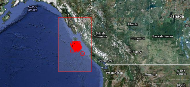
Image credit: TW
Canada’s Haida Gwaii region struck strong aftershock at 18:54 UTC on October 28, 2012 according to USGS. This is still preliminary magnitude but the event was reviewed by seismologist. Epicenter was located 159 km (98 miles) SSW of Masset, Canada at coordinates 52.633°N, 132.701°W. Recorded depth was 8.2 km (5.1 miles).
EMSC reported this earthquake as magnitude 5.8 with depth of 5 km.
| Magnitude | 6.3 |
|---|---|
| Date-Time |
|
| Location | 52.633°N, 132.701°W |
| Depth | 8.2 km (5.1 miles) |
| Region | QUEEN CHARLOTTE ISLANDS REGION |
| Distances | 159 km (98 miles) SSW of Masset, Canada 245 km (152 miles) SW of Prince Rupert, Canada 343 km (213 miles) SW of Terrace, Canada 595 km (369 miles) WNW of Campbell River, Canada |
| Location Uncertainty | horizontal +/- 18.5 km (11.5 miles); depth +/- 6.5 km (4.0 miles) |
| Parameters | NST=281, Nph=281, Dmin=317.3 km, Rmss=1.32 sec, Gp= 83°, M-type=regional moment magnitude (Mw), Version=8 |
| Source |
|
| Event ID | usb000dg06 |
Mainshock details
| Magnitude | 7.7 |
|---|---|
| Date-Time |
|
| Location | 52.769°N, 131.927°W |
| Depth | 17.5 km (10.9 miles) |
| Region | QUEEN CHARLOTTE ISLANDS REGION |
| Distances | 139 km (86 miles) S of Masset, Canada 202 km (125 miles) SSW of Prince Rupert, Canada 293 km (182 miles) SW of Terrace, Canada 556 km (345 miles) NW of Campbell River, Canada |
| Location Uncertainty | horizontal +/- 14 km (8.7 miles); depth +/- 4 km (2.5 miles) |
| Parameters | NST=716, Nph=716, Dmin=267.2 km, Rmss=0.95 sec, Gp= 58°, M-type=regional moment magnitude (Mw), Version=A |
| Source |
|
| Event ID | usb000df7n |
Tectonic summary by USGS
The October 28th, 2012 (October 27 at the location of the epicenter) M 7.7 earthquake south of Masset, Canada, occurred as a result of oblique-thrust faulting near the plate boundary between the Pacific and North America plates. At the location of this event, the Pacific plate moves approximately north-northwest with respect to the North America plate at a rate of approximately 50 mm/yr.This earthquake is likely associated with relative motion across the Queen Charlotte fault system offshore of British Columbia, Canada. Studies of tectonics in this region suggest plate motions are taken up by strike slip faulting parallel to the plate boundary, accompanied by lesser amounts of thrust motion to accommodate the oblique nature of the plate motion vector between the two plates with respect to the orientation of the main plate boundary fault structure. This oblique component of plate motion may involve either underthrusting of the western edge of the Pacific Plate beneath North America, or be taken up on crustal faults within the North America plate. The October 28th earthquake is consistent with either scenario. Its rupture extended approximately 100-150 km along strike, along the shallow extent of the source fault. Slip amounts reached approximately 5m, in a patch to the south of the epicenter. Aftershocks delineate the rupture well, as shown here.
This region of the Pacific:North America plate boundary has hosted 7 earthquakes of magnitude 6 or greater over the past 40 years – the largest of which was a M 6.6 earthquake in 2009, 80 km to the south east of the 2012 earthquake. In 1949, a M 8.1 earthquake occurred closer to the Pacific:North America plate boundary, likely as a result of strike-slip faulting, approximately 100 km northwest of the October 28th earthquake, near the northern extent of Haida Gwaii region (formerly Queen Charlotte Islands). Summary report.
Aftershock list

Update time = Sunday, October 28, 2012 – 19:48:04 UTC, Source: USGS
| MAG | UTC DATE-TIME y/m/d h:m:s | LAT deg | LON deg | DEPTH km | Region |
|---|---|---|---|---|---|
| 5.1 | 2012/10/28 19:16:56 | 52.555 | -132.496 | 47.6 | QUEEN CHARLOTTE ISLANDS REGION |
| 5.5 | 2012/10/28 19:09:56 | 52.315 | -131.860 | 14.8 | QUEEN CHARLOTTE ISLANDS REGION |
| 5.4 | 2012/10/28 19:03:25 | 52.742 | -132.901 | 32.8 | QUEEN CHARLOTTE ISLANDS REGION |
| 6.3 | 2012/10/28 18:54:22 | 52.633 | -132.701 | 8.2 | QUEEN CHARLOTTE ISLANDS REGION |
| 5.1 | 2012/10/28 16:17:04 | 52.380 | -131.664 | 15.0 | QUEEN CHARLOTTE ISLANDS REGION |
| 4.3 | 2012/10/28 15:24:22 | 52.803 | -132.113 | 10.0 | QUEEN CHARLOTTE ISLANDS REGION |
| 4.0 | 2012/10/28 15:10:34 | 52.516 | -132.066 | 10.0 | QUEEN CHARLOTTE ISLANDS REGION |
| 4.4 | 2012/10/28 15:06:55 | 52.417 | -132.169 | 10.0 | QUEEN CHARLOTTE ISLANDS REGION |
| 4.0 | 2012/10/28 14:14:29 | 52.588 | -131.440 | 7.7 | QUEEN CHARLOTTE ISLANDS REGION |
| 4.2 | 2012/10/28 14:04:28 | 52.635 | -132.403 | 10.0 | QUEEN CHARLOTTE ISLANDS REGION |
| 4.1 | 2012/10/28 13:45:49 | 51.127 | -130.305 | 10.0 | QUEEN CHARLOTTE ISLANDS REGION |
| 4.8 | 2012/10/28 13:09:14 | 52.432 | -131.882 | 10.2 | QUEEN CHARLOTTE ISLANDS REGION |
| 4.1 | 2012/10/28 12:38:46 | 52.870 | -132.204 | 10.1 | QUEEN CHARLOTTE ISLANDS REGION |
| 4.0 | 2012/10/28 12:18:00 | 52.689 | -131.870 | 9.8 | QUEEN CHARLOTTE ISLANDS REGION |
| 4.1 | 2012/10/28 12:09:43 | 52.568 | -132.065 | 10.0 | QUEEN CHARLOTTE ISLANDS REGION |
| 4.7 | 2012/10/28 11:53:21 | 52.438 | -132.201 | 10.5 | QUEEN CHARLOTTE ISLANDS REGION |
| 4.8 | 2012/10/28 11:27:46 | 52.395 | -132.161 | 11.1 | QUEEN CHARLOTTE ISLANDS REGION |
| 4.3 | 2012/10/28 11:17:23 | 52.400 | -131.565 | 10.6 | QUEEN CHARLOTTE ISLANDS REGION |
| 4.0 | 2012/10/28 10:59:15 | 52.477 | -131.769 | 9.7 | QUEEN CHARLOTTE ISLANDS REGION |
| 4.3 | 2012/10/28 10:50:33 | 52.484 | -131.945 | 10.3 | QUEEN CHARLOTTE ISLANDS REGION |
| 4.7 | 2012/10/28 10:45:50 | 52.621 | -132.500 | 10.2 | QUEEN CHARLOTTE ISLANDS REGION |
| 4.5 | 2012/10/28 10:23:09 | 52.753 | -132.678 | 10.2 | QUEEN CHARLOTTE ISLANDS REGION |
| 4.3 | 2012/10/28 10:10:28 | 52.482 | -132.248 | 10.3 | QUEEN CHARLOTTE ISLANDS REGION |
| 4.3 | 2012/10/28 10:04:38 | 52.924 | -132.395 | 10.3 | QUEEN CHARLOTTE ISLANDS REGION |
| 4.1 | 2012/10/28 09:52:59 | 52.892 | -131.733 | 10.0 | QUEEN CHARLOTTE ISLANDS REGION |
| 4.4 | 2012/10/28 09:45:39 | 52.886 | -132.392 | 10.2 | QUEEN CHARLOTTE ISLANDS REGION |
| 4.4 | 2012/10/28 09:41:17 | 52.029 | -132.187 | 10.0 | QUEEN CHARLOTTE ISLANDS REGION |
| 4.6 | 2012/10/28 09:36:37 | 52.258 | -132.343 | 10.3 | QUEEN CHARLOTTE ISLANDS REGION |
| 4.4 | 2012/10/28 09:22:50 | 52.467 | -131.439 | 10.7 | QUEEN CHARLOTTE ISLANDS REGION |
| 5.1 | 2012/10/28 09:17:28 | 52.216 | -132.006 | 10.5 | QUEEN CHARLOTTE ISLANDS REGION |
| 4.2 | 2012/10/28 09:15:49 | 52.102 | -131.653 | 10.0 | QUEEN CHARLOTTE ISLANDS REGION |
| 4.3 | 2012/10/28 08:22:04 | 52.066 | -132.073 | 10.0 | QUEEN CHARLOTTE ISLANDS REGION |
| 5.0 | 2012/10/28 07:25:22 | 52.270 | -131.493 | 10.6 | QUEEN CHARLOTTE ISLANDS REGION |
| 4.9 | 2012/10/28 07:16:38 | 52.775 | -132.456 | 11.4 | QUEEN CHARLOTTE ISLANDS REGION |
| 4.6 | 2012/10/28 07:12:14 | 52.109 | -132.221 | 10.0 | QUEEN CHARLOTTE ISLANDS REGION |
| 4.4 | 2012/10/28 07:02:19 | 51.941 | -131.836 | 10.8 | QUEEN CHARLOTTE ISLANDS REGION |
| 5.0 | 2012/10/28 06:16:53 | 52.268 | -131.212 | 11.5 | QUEEN CHARLOTTE ISLANDS REGION |
| 4.5 | 2012/10/28 05:51:17 | 52.815 | -132.714 | 10.3 | QUEEN CHARLOTTE ISLANDS REGION |
| 4.2 | 2012/10/28 05:47:09 | 52.429 | -131.451 | 10.1 | QUEEN CHARLOTTE ISLANDS REGION |
| 4.1 | 2012/10/28 05:38:38 | 51.786 | -132.312 | 10.1 | QUEEN CHARLOTTE ISLANDS REGION |
| 4.3 | 2012/10/28 05:21:37 | 52.139 | -131.571 | 10.0 | QUEEN CHARLOTTE ISLANDS REGION |
| 4.3 | 2012/10/28 05:15:13 | 52.499 | -132.222 | 10.1 | QUEEN CHARLOTTE ISLANDS REGION |
| 4.5 | 2012/10/28 05:02:50 | 52.409 | -132.165 | 10.3 | QUEEN CHARLOTTE ISLANDS REGION |
| 4.3 | 2012/10/28 04:54:46 | 52.403 | -132.439 | 10.1 | QUEEN CHARLOTTE ISLANDS REGION |
| 4.7 | 2012/10/28 04:41:05 | 52.592 | -132.670 | 10.0 | QUEEN CHARLOTTE ISLANDS REGION |
| 4.6 | 2012/10/28 04:33:51 | 52.906 | -133.120 | 10.0 | QUEEN CHARLOTTE ISLANDS REGION |
| 5.1 | 2012/10/28 04:25:17 | 52.019 | -133.370 | 10.1 | QUEEN CHARLOTTE ISLANDS REGION |
| 4.8 | 2012/10/28 03:52:25 | 52.199 | -131.986 | 10.9 | QUEEN CHARLOTTE ISLANDS REGION |
| 7.7 | 2012/10/28 03:04:11 | 52.769 | -131.927 | 17.5 | QUEEN CHARLOTTE ISLANDS REGION |
I'm a dedicated researcher, journalist, and editor at The Watchers. With over 20 years of experience in the media industry, I specialize in hard science news, focusing on extreme weather, seismic and volcanic activity, space weather, and astronomy, including near-Earth objects and planetary defense strategies. You can reach me at teo /at/ watchers.news.
I have a contingency plan and my bug-out-bag is gtg in the event EQs unzip land mass and displace salt water along the Pacific coast. I am 50 yards away from the Pacific ocean shoreline and I am concerned about the rumbles me and others have experienced in the past few weeks.
Many of us have plans to move far away from the ocean as possible including a move to another state. As scenic as it is to live here it is becoming a hazard as tsunami warnings were blasted over the beach speaker system last night and again today. I have noticed in the past few weeks the beach tsunami warning system has been tested and on alert as EQs and tremors become more frequent.