
Tropical Storm Prapiroon formed in west Pacific
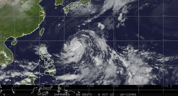
Image credit: TW
Tropical Depression 22W become Tropical Storm Prapiroon on October 7 and now is located approximately 640 nm southeast of Kadena AB, Okinawa, Japan. The system is moving westward at 06 knots (11 km/h) over the past six hours. Maximum sustained winds are about 5o knots (93 km/h) with gusts up to 65 knots (120 km/h).
Upper-level analysis continues to show Prapiroon has near-radial outflow in an area of low (05-10 knot) vertical wind shear. Due to warm ocean waters and low wind shear over the region, Prapiroon is expected to continue strengthening and should become a typhoon by midweek.

As the trough currently located over eastern Japan propagates eastward, the subtropical ridge is forecast to re-build
briefly, allowing Prapiroon to continue tracking westward.
For now it looks like Prapiroon could target Japan next week.

The majority of the dynamic models indicate increased east-northeasterly winds (gale-force) over Okinawa by the end of the week due to an enhanced gradient between Prapiroon and an east-west oriented frontal system.

Satellite Animations
- Storm-Centered Infrared (MTSAT; NOAA/SSD)
- Storm-Centered Infrared (Aviation Color Enhancement) (MTSAT; NOAA/SSD)
- Storm-Centered Water Vapor (MTSAT; NOAA/SSD)
- Storm-Centered Visible (MTSAT; NOAA/SSD)
- Storm-Centered Visible (Colorized) (MTSAT; NOAA/SSD)
- Tropical West Pacific Infrared (MTSAT2; NOAA)
- Tropical West Pacific Enhanced Infrared (MTSAT2; NOAA)
- Tropical West Pacific Water Vapor (MTSAT2; NOAA)
- Tropical West Pacific Visible (MTSAT2; NOAA)
Commenting rules and guidelines
We value the thoughts and opinions of our readers and welcome healthy discussions on our website. In order to maintain a respectful and positive community, we ask that all commenters follow these rules.