
Magnitude 6.0 earthquake struck southern Peru
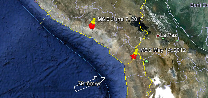
Image credit: Google Earth + USGS
Strong earthquake with recorded magnitude of 6.0 struck southern Peru on June 7, 2012 at 16:03 UTC according to USGS. Epicenter was located 119 km (74 miles) WNW (298°) from Arequipa, Peru (15.919°S, 72.516°W). Recorded depth was 99.7 km (62.0 miles). EMSC is reporting 6.2 magnitude with depth of 80km.
| Magnitude | 6.0 |
|---|---|
| Date-Time |
|
| Location | 15.919°S, 72.516°W |
| Depth | 99.7 km (62.0 miles) |
| Region | SOUTHERN PERU |
| Distances |
|
| Location Uncertainty | horizontal +/- 16 km (9.9 miles); depth +/- 8.4 km (5.2 miles) |
| Parameters | NST=450, Nph=543, Dmin=470.9 km, Rmss=0.91 sec, Gp= 54°, M-type=teleseismic moment magnitude (Mw), Version=A |
| Source |
|
| Event ID | usb000a9lp |

Population exposure

Selected Cities Exposed from GeoNames Database of Cities with 1,000 or more residents.
| MMI | City | Population |
|---|---|---|
| IV | Lluta | 6k |
| IV | Orcopampa | 6k |
| IV | Camana | 16k |
| IV | Yura | 6k |
| IV | Chivay | 5k |
| IV | Pucara | 4k |
| IV | Arequipa | 841k |
| III | Moquegua | 55k |
| III | Abancay | 55k |
| III | Puno | 117k |
| III | Cusco | 312k |
Historic seismicity – 2012


I'm a dedicated researcher, journalist, and editor at The Watchers. With over 20 years of experience in the media industry, I specialize in hard science news, focusing on extreme weather, seismic and volcanic activity, space weather, and astronomy, including near-Earth objects and planetary defense strategies. You can reach me at teo /at/ watchers.news.
Commenting rules and guidelines
We value the thoughts and opinions of our readers and welcome healthy discussions on our website. In order to maintain a respectful and positive community, we ask that all commenters follow these rules.