
Two strong and shallow earthquakes struck south of Panama
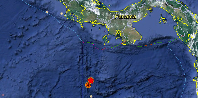
Image credit: Google Earth + USGS
The first one struck at 00:45 UTC on June 4, 2012 with magnitude 6.2 according USGS. Epicenter was located 356 km (221 miles) SSW of Santiago, Panama and 526 km (326 miles) SW of Panama City, Panama (5.287°N, 82.580°W). Recorded depth was 9.7 km (6.0 miles).
Based on the earthquake magnitude, location, and historic tsunami records, a tsunami is not expected, the Pacific Tsunami Warning Center said.
| Magnitude | 6.2 |
|---|---|
| Date-Time |
|
| Location | 5.287°N, 82.580°W |
| Depth | 9.7 km (6.0 miles) |
| Region | SOUTH OF PANAMA |
| Distances | 346 km (214 miles) S of David, Panama 356 km (221 miles) SSW of Santiago, Panama 372 km (231 miles) SW of Las Tablas, Panama 526 km (326 miles) SW of PANAMA CITY, Panama |
| Location Uncertainty | horizontal +/- 15.5 km (9.6 miles); depth +/- 2.6 km (1.6 miles) |
| Parameters | NST=567, Nph=577, Dmin=525.4 km, Rmss=0.87 sec, Gp= 47°, M-type=teleseismic moment magnitude (Mw), Version=C |
| Source |
|
| Event ID | usb000a664 |

Two and a half hours later, at 3:15 UTC a second earthquake struck almost the same area. The magnitude of this one was measured as 6.4 according to USGS. Epicenter was located 330 km (205 miles) SSW of Santiago, Panama and 501 km (311 miles) SW of Panama City, Panama (5.507°N, 82.457°W). Recorded depth was 5.9 km (3.7 miles)
| Magnitude | 6.4 |
|---|---|
| Date-Time |
|
| Location | 5.507°N, 82.457°W |
| Depth | 5.9 km (3.7 miles) |
| Region | SOUTH OF PANAMA |
| Distances | 323 km (200 miles) S of David, Panama 330 km (205 miles) SSW of Santiago, Panama 347 km (215 miles) SW of Las Tablas, Panama 501 km (311 miles) SW of PANAMA CITY, Panama |
| Location Uncertainty | horizontal +/- 13.1 km (8.1 miles); depth +/- 2.6 km (1.6 miles) |
| Parameters | NST=538, Nph=552, Dmin=497.6 km, Rmss=1.03 sec, Gp= 40°, M-type=(unknown type), Version=A |
| Source |
|
| Event ID | usb000a66u |
Historical seismicity map

I'm a dedicated researcher, journalist, and editor at The Watchers. With over 20 years of experience in the media industry, I specialize in hard science news, focusing on extreme weather, seismic and volcanic activity, space weather, and astronomy, including near-Earth objects and planetary defense strategies. You can reach me at teo /at/ watchers.news.
[…] die Erde bebt in Panama […]