
Strong and deep M6.4 earthquake struck Tonga region
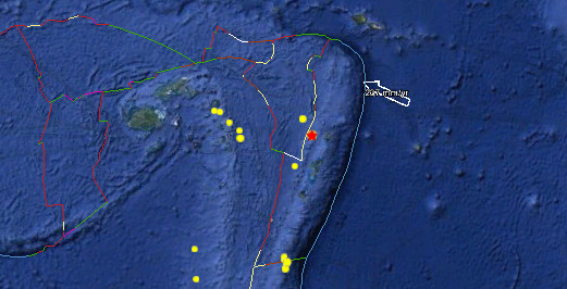
Image credit: Google Earth + USGS
Strong and deep earthquake with magnitude 6.4 struck Tonga region on April 28, 2012. Epicenter was located 78 km (48 miles) W of Neiafu, Tonga (18.643°S, 174.725°W). Recorded depth was 129.4 km (80.4 miles) by USGS.
Earthquake was harmless for shaking damage and tsunami as the depth and source of earthquake is unable to generate strong shaking or tsunami waves. Additionaly, the people living in this region are familiar with strong shaking.
| Magnitude | 6.7 |
|---|---|
| Date-Time |
|
| Location | 18.643°S, 174.725°W |
| Depth | 129.4 km (80.4 miles) |
| Region | TONGA |
| Distances | 78 km (48 miles) W of Neiafu, Tonga 280 km (173 miles) N of NUKU`ALOFA, Tonga 315 km (195 miles) SSW of Hihifo, Tonga 2266 km (1408 miles) NNE of Auckland, New Zealand |
| Location Uncertainty | horizontal +/- 15 km (9.3 miles); depth +/- 4.6 km (2.9 miles) |
| Parameters | NST=454, Nph=457, Dmin=611.1 km, Rmss=0.81 sec, Gp= 22°, M-type=centroid moment magnitude (Mw), Version=9 |
| Source |
|
| Event ID | usc0009e33 |

Historical seismicity – M7 and greater since 1900


Teo Blašković founded The Watchers in 2011 and edited it until 2026, covering seismic and volcanic activity, extreme weather, space weather and near-Earth objects. Articles on this page are his archive.
Published in the last 24 hours
- Male toads abandoned a pond in Italy five days before a deadly 2009 earthquake, while a scientist was counting them Epicenter
- An asteroid was spotted 19 hours before it exploded over Sudan in 2008, and students picked its pieces off the desert Epicenter
- A wave up to 3 m (10 feet) high rose out of Lake Michigan on a sunny June morning in 1954 and swept fishermen off Chicago’s piers, and when a second came 10 days later, warnings had cleared the shore Epicenter
- Just 12 inches of rushing water can carry away most cars, and more than half of US flood drownings happen to people who drive into flood water Epicenter
