
New volcanic island emerged in Red Sea
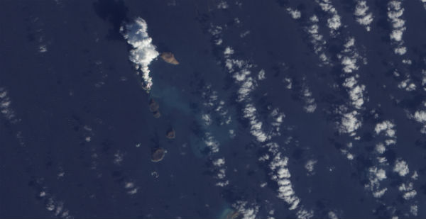
Image credit: TW
A small submarine eruption took place off the western coast of Yemen creating new island in the Red Sea. Just like during the Eritrea Nabro eruption, satellite images are the only source in this part of the world considering other problems that the region experiencing. It seems like there is a lot of confusion about exactly where the eruption is taking place. A number of sources put the eruption at Jebel Zubair, an island volcano that is part of an archipelago that last erupted in 1824. Jebel Zubair is just to the south of Jebel at Tair.
Imagery acquired on 23 December from the Advanced Land Imager (ALI) on NASA’s EO-1 satellite showed a new island at the location with a plume rising from it, roughly 500 m N of Rugged Island and more than 500 m in diameter.
The Monitoring Center for the Study of Earthquakes and Volcanoes has reported the presence of light volcanic activity on one of the unpopulated islands of ‘Jabal Al-Zubair’ archipelago, 120 km northwest of Hodeida Governorate. The centre has commissioned technical experts to travel to the site of the volcano to conduct studies. The team has installed a seismic monitoring station there to alert them to seismic activity that may be the precursor to volcanic activity. Region has seen less seismic activity in 2011 than in 2010, when more than 6500 instances of seismic activity were recorded. (YemenTimes)

The 5-km-long Jebel Zubair Island is the largest of a group of 10 small islands and submerged shoals that rise from a shallow platform in the Red Sea rift. The platform and eruptive vents forming the islands and shoals are oriented NNW-SSE, parallel to the rift. An early explosive phase was followed by a brief period of marine erosion, and then by renewed explosive activity accompanied by the extrusion of basaltic pahoehoe lava flows. This latest phase of activity occurred on the morphologically youngest islands of Zubair, Centre Peak, Saba, and Haycock. Historical explosive activity was reported from Saddle Island in the 19th century. Spatter cones and pyroclastic cones were erupted along fissures that form the low spine of Zubair Island. (GVP)
The results of a survey of the area’s volcanic history showed that Jabal Al-Zubair is an active volcanic site, and that it witnessed volcanic activity 187 years ago. In September 2007, a volcano on Jabal Al-Tair Island – 20 km southwest of Al-Zubair and 140 kilometers off Yemen’s western coastline – caused the death of eight Yemeni soldiers in addition to injuring others stationed at a military base.

On December 19 the NASA Aura/OMI SO² satellite captured a picture that revealed a strong SO² cloud column. This satellite is of great importance to detect remote located volcanoes.

MODIS imagery from 20 December shows a plume rising from a submarine eruption about 1.5 km SW of Haycock and N of Rugged (near the N end of the Az-Zubair island group), and about 12 km NE of Jebel Zubair island. A bathymetric sketch map made in 1973 indicates a water depth of about 100 m in that area.
MODIS imagery from NASA’s satellites on 22 December showed a plume, possibly containing ash, rising from what was thought to be a submarine eruption. Imagery acquired on 23 December from the Advanced Land Imager (ALI) on NASA’s EO-1 satellite showed a new island at the location with a plume rising from it, roughly 500 m N of Rugged Island and more than 500 m in diameter. The island was not present in a similar image acquired on 24 October 2007.

The Picture combination (above) from NASA Earth Observatory shows the birth of the new island. The cloud picture was acquired by the Advanced Land Imager (ALI) on NASA’s Earth Observing-1 (EO-1) satellite. A thick plume rises from the island, dark near the bottom and light near the top, perhaps a mixture of volcanic ash and water vapor.
The 5-km-long Jebel Zubair Island is the largest of a group of 10 small islands and submerged shoals that rise from a shallow platform in the Red Sea rift. The platform and eruptive vents forming the islands and shoals are oriented NNW-SSE, parallel to the rift. An early explosive phase was followed by a brief period of marine erosion, and then by renewed explosive activity accompanied by the extrusion of basaltic pahoehoe lava flows. This latest phase of activity occurred on the morphologically youngest islands of Zubair, Centre Peak, Saba, and Haycock. Historical explosive activity was reported from Saddle Island in the 19th century. Spatter cones and pyroclastic cones were erupted along fissures that form the low spine of Zubair Island.
Commenting rules and guidelines
We value the thoughts and opinions of our readers and welcome healthy discussions on our website. In order to maintain a respectful and positive community, we ask that all commenters follow these rules.