
Fires near Yakutsk, Russia
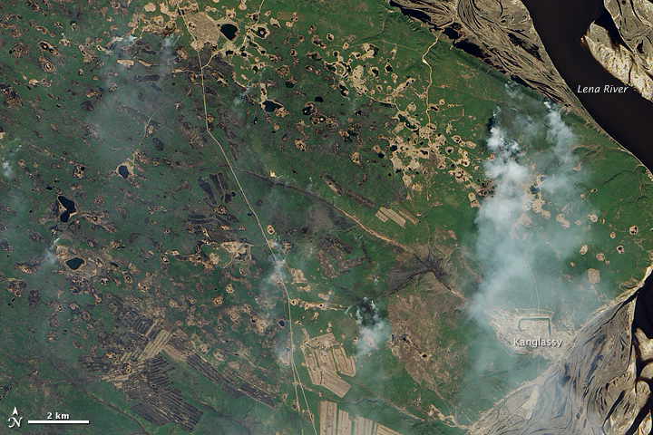
Image credit: TW
Deep green needle-leaf forests stretch away from the Lena River in Russia’s remote eastern reaches. Siberian larch trees mingle with patches of fragrant pine, while brush and moss cling to the ground. Unlike most coniferous trees, the larch sheds its needles at the end of the year, coating the forest floor with a flammable layer of dry, yellow kindling.
When winter’s snow melts away and the ground dries out, the larch forest is very prone to fire, particularly in May and June. The Advanced Land Imager (ALI) on NASA’s Earth Observing-1 (EO-1) satellite captured these images on May 24, 2011, just after fire swept through the forest. The top image shows the burning landscape in natural color. The land is faintly charred, and smoke pours from the edge of the burned area where the fire was still active.
The lower image, made from a combination of visible and infrared light, provides a clearer view of the severity of the burn. Places that burned completely are brick red. Much of the burned area is spotted with green, revealing trees that survived the fire. Hot spots along the edges glow orange.

The fire in this image is one of many that swept through the boreal forests of far eastern Russia in late May and early June. Though it’s not possible to tell what started this particular fire from an image alone, 90 percent of fires within 90 kilometers of a settlement are set by people, says Slava Kharuk of the Sukachev Institute of Forests in Krasnoyarsk. Outside that area, 40 percent of the fires are set by people and 60 percent are caused by lightning.
Regardless of how the fire started, the image includes signs of people in the area. Thin tan lines—roads—cross the image, and some of the burned areas are perfect rectangles where no plants survived the fire. It is possible that the fire that burned the wider area escaped from one or more of these human-controlled areas. The wider wild fire appears to have been less intense, sparing pockets of forest.
Thousands of kilometers away, scientists on the EO-1 team breathed a sigh of relief when they learned that the forest survived. The site hosts two observation towers with instruments that monitor the health of the forest. Scientists at NASA compare these measurements to data from the Hyperion instrument, which shares the EO-1 satellite with the Advanced Land Imager. The comparison with ground-based data helps scientists understand what Hyperion measurements say about the forest. The Hyperion measurements in turn help monitor forests around the world.
NASA Earth Observatory image created by Jesse Allen and Robert Simmon, using EO-1 ALI data provided courtesy of the NASA EO-1 team. Caption by Holli Riebeek with information from Petya Campell, Hyperion Science team, and Slava Kharuk, Sukachev Institute of Forests. (EarthObservatory)
NASA Earth Observatory image created by Jesse Allen and Robert Simmon, using EO-1 ALI data provided courtesy of the NASA EO-1 team. Caption by Holli Riebeek with information from Petya Campell, Hyperion Science team, and Slava Kharuk, Sukachev Institute of Forests.
Commenting rules and guidelines
We value the thoughts and opinions of our readers and welcome healthy discussions on our website. In order to maintain a respectful and positive community, we ask that all commenters follow these rules.