
Army blast Bird Point-New Madrid Leeve, Historic flooding ongoing
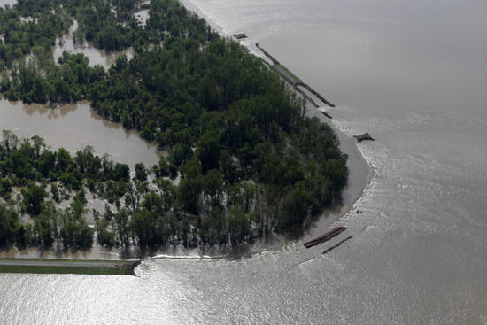
Image credit: TW
As record flooding continues along the Mississippi River, the operation to breach a levee to save an Illinois town was carried out Monday night. The Army Corps of Engineers exploded the levee in the agricultural community of Birds Point, Montana, Monday night to relieve pressure on the levee at nearby Cairo, Illinois. The blast allowed water from the swollen Mississippi River to flood 130,000 acres of prime agricultural lands in southeastern Missouri. The Associated Press states about 100 homes of farmers are located on that land.

Officials deemed the explosion necessary to prevent severe flooding in Cairo, which sits where the Ohio River runs into the Mississippi River. The Ohio River at Cairo had surged past its previous record stage of 59.5 feet Saturday night. That record was set in early February 1937.
The river peaked at 61.72 feet Monday night, but dropped a foot in seven hours following the blast. The flooding along the lower Mississippi River will continue to get worse, and could become yet another natural disaster for the U.S. this year. The region is about to turn into a vast lake that will linger not only days, but weeks due to the very slow-to-respond, massive rivers in a relatively flat part of the nation.


Impacts will range from large agricultural areas and small farmsteads being swallowed by deep waters to unprotected small towns and portions of large cities being flooded by muddy inundations. Part of the area where the Mississippi and Ohio rivers meet has received over 2 feet of rain in a little over three weeks.
The latest round of rain that arrived this past weekend is finally pushing eastward and will fully depart the Ohio and Mississippi valleys by tonight. Before the rain leaves, an additional 1 to 2 inches will come down in the Ohio Valley.


In some cases, prior to this past weekend’s rainfall, the rivers were cresting or had crested. However, the additional recent deluge of rain will bring a second crest that could be higher than the first in some cases, and prolong flooding in almost all areas.
At Tiptonville, Tenn., the Mississippi River is forecast to reach at least 51 feet, topping the record set on February 7, 1937 of 47.8 feet. Farther south, in areas such as those near Memphis, river levels next week and beyond may challenge flooding that occurred during April of 1927.
A breach in the levee has occurred along the Mississippi River near Thebes, Ill. during Monday midday and will contribute to flooding in Olive Branch and Cairo.
Due to the very slow progression of flood waters in the region, levees in many areas will feel the strain of high water for weeks.


Along the Ohio, most problems are occurring from where the Wabash River joins in, onward to the Mississippi and the vicinity around Cairo, Illinois. The Wabash and other rivers that feed into the Ohio and Mississippi are also at moderate to record levels. In some cases, the rivers are backing up as they encounter the high water of the larger waterways.
The surge of water will work its way southward in the weeks ahead. The amount and location of additional rain that falls will determine the severity of the rise and potential flooding along the lowest portion of the Mississippi Valley and the Delta. A break in the rain is coming tonight into Thursday. However, additional downpours are forecast by AccuWeather.com meteorologists late in the week through the weekend over much of the Ohio and middle and lower Mississippi valleys.

In addition to river flooding in the region, potential for flash and urban flooding will extend well beyond the flood zone of the Ohio and Mississippi rivers and their tributaries for the next couple of days to the next couple of weeks.
Rivers and streams are also running high in the Northeast and the northern Plains. Communities along flood-prone waterways in these regions will need to keep an eye on the weather for at least the next couple of weeks. (AccuWeather)

Late on May 2, 2011, in an effort to spare Cairo, Illinois, the U.S. Army Corps of Engineers used explosives to breach a protective levee near the confluence of the Ohio and Mississippi Rivers. As predicted, the two-mile hole in the levee flooded 130,000 acres of nearby farmland in what is known as the Birds Point-New Madrid Floodway.
The Moderate Resolution Imaging Spectroradiometer (MODIS) on NASA’s Aqua satellite captured these images of the area on May 3, 2011 (top), and April 29, 2011 (bottom). Both images use a combination of visible and infrared light to increase constrast between water and land. Water ranges in color from electric blue to navy. Vegetation is green. Clouds are pale blue-green and cast shadows onto the land surface below.
Tiny squares of green in the April 29 image show that the floodway consists of farmland. The image from April 29 also shows flooded conditions along the Ohio and Mississippi Rivers. (See an image from 2010 for a comparison.) In the image acquired on May 3, the floodway downstream of Cairo is submerged. The same day that MODIS acquired the image, the Advanced Hydrological Prediction Service of the U.S. National Weather Service reported that the water level for the Ohio River at Cairo had dropped, although it still remained at major flood stage. (EO)


Commenting rules and guidelines
We value the thoughts and opinions of our readers and welcome healthy discussions on our website. In order to maintain a respectful and positive community, we ask that all commenters follow these rules.