
Record rains and flash floods prompt water rescues in Kansas City, U.S.
Record rainfall caused flash flooding in Kansas City, Missouri, on Thursday, July 24, 2025, submerging streets and prompting multiple water rescues.
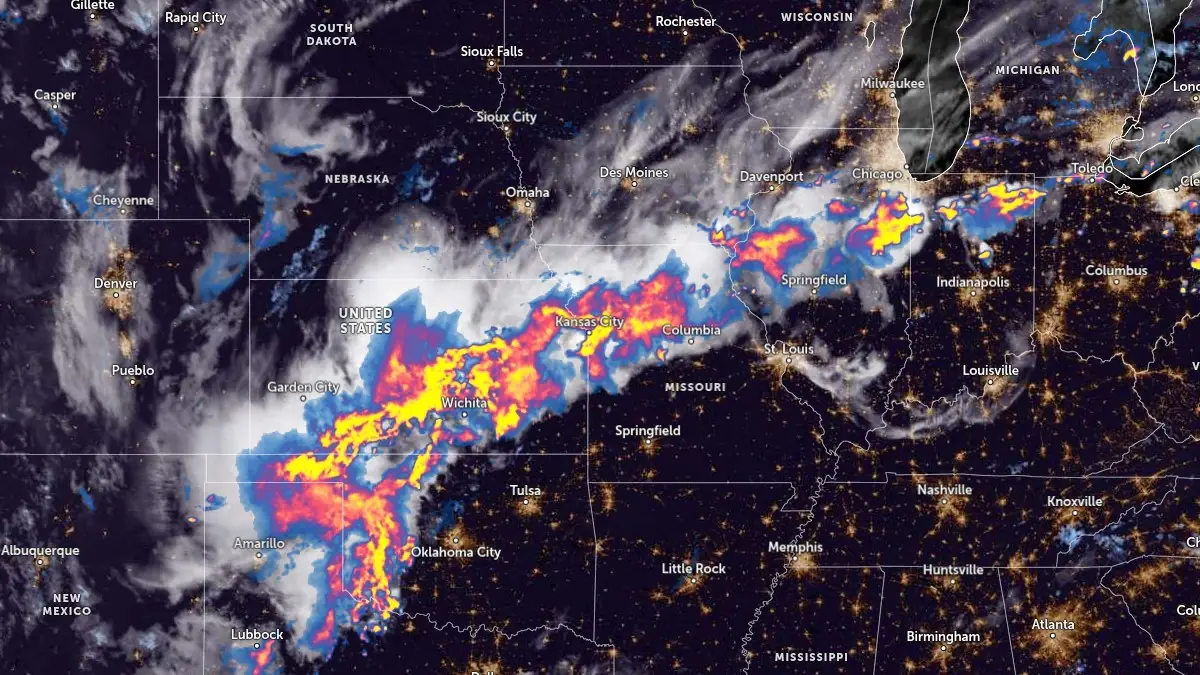
Image credit: NOAA/GOES-East, Zoom Earth, The Watchers. Acquired at 07:50 UTC on July 25, 2025
Record rainfall struck Kansas City, Missouri on Thursday, July 24, causing flash floods across the metropolitan area.
Kansas City received 2.35 inches (59.7 mm) of rainfall, tying the previous daily record set in 1900. Additionally, Fox Weather reported the city recorded 8.66 inches (220 mm) of rainfall as of early Thursday, tying July 2024 with July 1896 for the 14th wettest on record.
Between 75 and 100 mm (3 to 4 inches) of rain fell over parts of Missouri and Kansas through Thursday, leading to widespread flooding. Numerous streets were inundated, prompting multiple water rescues in affected areas.


The Kansas City Fire Department responded to 10 water rescues since 02:46 LT on July 25, according to Battalion Chief Riley Nolan. Each incident involved vehicles stranded in high water across multiple locations.
Two of the calls were initially reported as motor vehicle accidents but were reclassified as water rescues. No injuries have been reported so far.
The flooding has led to the closure of MO-78 east of I-435 in Jackson County, Missouri, causing significant traffic disruptions. Nolan urged residents to avoid driving during heavy rain and warned against walking through floodwaters, noting that displaced sewer covers pose life-threatening risks.
Heavy rainfall is forecast to continue, with up to 125 mm (5 inches) expected over parts of Kansas and Missouri through Friday, July 26.


Rishav Kothari is Editor-in-Chief of The Watchers, where he runs the newsroom and covers earthquakes, volcanoes, severe weather and space weather.
Published in the last 24 hours
- Strong El Niño reinforces above-normal winter precipitation outlook across southern and eastern U.S.
- Scientists directly observe how submarine landslides unfold in western Canada Epicenter
- Odisha evacuated 983,642 people before Phailin crossed near Gopalpur on 12 October 2013 with winds of 200-210 km/h gusting to 220, and 44 died, against 9,885 in the 1999 super cyclone. Cyclone Akvan crossed the same coast on 20 November 2026. Epicenter
- Lava fountains reached 1,900 feet (580 m) at Kīlauea Iki in 1959, the highest ever recorded at Kīlauea, as USGS forecasts episode 57 fountaining at Halemaʻumaʻu for November 22-26. Epicenter
