
Typhoon Dujuan brings record rainfall to eastern Japan, JMA issues Level 5 landslide warning for Oshima
Rainfall on Oshima reached 600 mm (23.6 inches) in the 24 hours ending at 14:00 LT (05:00 UTC) on September 21, 2026, as Typhoon Dujuan passed the Izu Islands and approached eastern Japan. The record rainfall prompted a Level 5 landslide special warning, while flooding, landslides and transport disruption affected parts of the Kanto region.

Satellite image of Typhoon Dujuang at 1050 UTC on September 21, 2026. Credit: JMA/Himawari-9, RAMMB/CIRA, The Watchers
Typhoon Dujuan brought 600 mm (23.6 inches) of rain to Oshima in the Izu Islands during the 24 hours ending at 14:00 LT (05:00 UTC) on September 21, 2026, prompting the Japan Meteorological Agency (JMA) to issue a Level 5 landslide special warning.
Flooding and landslides affected Chiba Prefecture as the cyclone moved northeast past the islands, while Level 5 emergency safety notices were issued in several municipalities and nearly 45 000 customer accounts across the Tokyo Electric Power Company service area were without electricity by early evening.
At 15:00 LT (06:00 UTC), the Joint Typhoon Warning Center (JTWC) placed the center of Dujuan approximately 335 km (208 miles) south-southwest of Yosuka, Japan, moving northeastward at approximately 30 km/h (19 mph). Maximum one-minute sustained winds were estimated at 130 km/h (81 mph), with a minimum central pressure of 971 hPa.
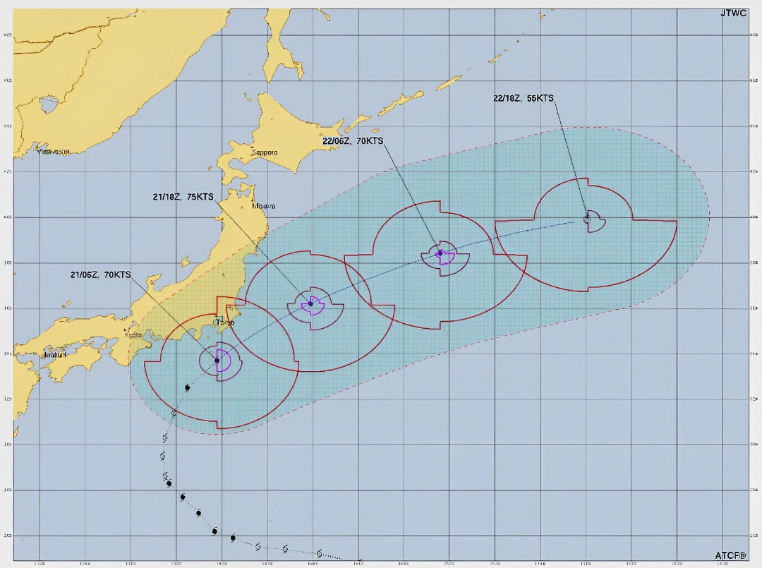
JMA refers to the cyclone as Typhoon No. 25, while JTWC designates it as 24W. Japan’s Ministry of Land, Infrastructure, Transport and Tourism (MLIT) described it as a large and strong typhoon at 12:00 LT (03:00 UTC).
The agency recorded 600 mm (23.6 inches) of rain on Oshima during the 24 hours ending at 14:00 LT, a September record for the observation site. MLIT reported that rainfall since September 19 had already exceeded 500 mm (19.7 inches) in the Izu Islands and 300 mm (11.8 inches) in Chiba Prefecture by early afternoon.
JMA issued the Level 5 landslide special warning for Oshima Town at 12:40 LT (03:40 UTC). The agency said a disaster might already have occurred within designated landslide-hazard areas and urged residents to take immediate action to protect their lives.
Oshima Town issued Level 5 emergency safety information for the entire municipality at 12:46 LT (03:46 UTC), covering 1 901 households and 3 020 residents. The town had opened 10 shelters, where 72 people were staying as of approximately 13:30 LT (04:30 UTC).
In Chiba Prefecture, MLIT confirmed three landslides by 14:00 LT (05:00 UTC). One home was destroyed, and another was partially damaged, according to the ministry’s fourth situation report.
Conditions deteriorated later in the day. Level 5 emergency safety notices were issued in parts of Kimitsu, Sodegaura, Ichihara, Otaki and Sanmu as authorities warned of flooding, rising rivers and landslide danger.

The Koito River had flooded in Kimitsu, and a road had collapsed in Chiba City’s Midori Ward while flooding, overflowing manholes, or inundated roads had been observed in at least 28 municipalities across the prefecture.
Transport disruption increased as the storm approached. 384 flights were canceled on September 21 as of 11:00 LT (02:00 UTC), including 135 Japan Airlines flights and 139 All Nippon Airways flights.
The ministry said 16 conventional railway lines operated by eight companies were suspended as of 13:45 LT (04:45 UTC). Six expressway routes were closed across 32 sections because of rainfall thresholds or wave overtopping, while nine prefectural road sections in Chiba were closed by surface flooding as of 12:00 LT (03:00 UTC).
Power outages also expanded during the afternoon and evening. Tokyo Electric Power Company Power Grid data showed nearly 45 000 customer accounts without electricity at 19:19 LT (10:19 UTC), including approximately 33 950 in Chiba Prefecture, 5 650 in Kanagawa Prefecture, 1 660 in Yamanashi Prefecture and 1 000 in Saitama Prefecture. The cause of the outages was under investigation.

JMA forecast additional rainfall during the 24 hours ending at 12:00 LT (03:00 UTC) on September 22, with up to 250 mm (9.8 inches) expected in the Izu Islands and Kanto region and 150 mm (5.9 inches) in Tohoku.
At a news conference at 13:40 LT (04:40 UTC), JMA warned that landslide danger could remain elevated after the rain ended and called for continued vigilance into the early hours of September 22.
JTWC estimated a maximum significant wave height of 9.8 m (32 feet) near the cyclone at 06:00 UTC on September 21. Significant wave height is the average height of the highest one-third of waves and does not represent conditions at every harbor or coastal location.
JTWC Warning No. 024, issued at 09:00 UTC, forecast a brief increase in maximum sustained winds to 140 km/h (87 mph) by 18:00 UTC on September 21. The agency expected Dujuan to accelerate northeastward and begin extratropical transition on September 22, with weakening forecast as vertical wind shear increased and the system encountered drier air and cooler water.
JTWC attributed the storm’s northeastward motion to its movement around the northwestern edge of a subtropical ridge east-southeast of Japan. Strong poleward outflow and warm water near the Kuroshio Current supported short-term intensification before the cyclone entered the mid-latitude westerlies.
References:
1 Level 5 landslide special warning issued for the northern Izu Islands, Tokyo – JMA – September 21, 2026
2 TYPHOON 24W (DUJUAN) WARNING NR 024 Typhoon 24W (Dujuan) Warning NR 024 – JTWC – September 21, 2026
3 Damage and response status following Typhoon No. 25 — Report No. 4 – MLIT – September 21, 2026, 15:00 LT

Rishav Kothari is Editor-in-Chief of The Watchers, where he runs the newsroom and covers earthquakes, volcanoes, severe weather and space weather.
