
Edouard weakens to tropical depression over Texas, WPC warns of significant flash flooding
Tropical Storm Edouard made landfall near Johnson Bayou, Louisiana, at 14:20 CDT (19:20 UTC) on September 1, 2026, with winds of 95 km/h (60 mph), then weakened to a tropical depression over southeastern Texas. The Weather Prediction Center forecast storm-total rainfall of 102–203 mm (4–8 inches), with localized totals near 305 mm (12 inches), while Flood Watches remained in effect and approximately 70 000 Entergy Texas customers were without power late September 1.

Satellite image of Tropical Storm Edouard at 19:20 UTC on September 1, 2026. Credit: NOAA/GOES-19, RAMMB/CIRA, The Watchers
- Tropical Storm Edouard made landfall near Johnson Bayou, Louisiana, at 14:20 CDT (19:20 UTC) on September 1 with maximum sustained winds of 95 km/h (60 mph) and a minimum central pressure of 996 hPa.
- The storm brought strong winds, heavy rainfall, and power outages to parts of southeastern Texas and southwestern Louisiana, with approximately 70 000 Entergy Texas customers without electricity late September 1.
- Heavy rain bands associated with Edouard are forecast to move north of the Upper Texas Coast and southwestern Louisiana during the morning of September 2, then track slowly across east-central Texas through the morning of September 3. Flash flooding is likely, particularly in urban and low-lying areas, with significant flash flooding possible. River flooding is also possible.
Edouard crossed the coast approximately 25 km (15 miles) south-southeast of Port Arthur, Texas, according to the National Hurricane Center (NHC). Its minimum central pressure at landfall was estimated at 996 hPa.
A National Ocean Service station near Texas Point, Texas, measured sustained winds of 93 km/h (57 mph) and a gust of 114 km/h (71 mph) around the time of landfall.
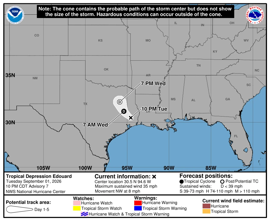
At 04:00 CDT (09:00 UTC) on September 2, the center of Tropical Depression Edouard was near 30.8°N, 95.0°W, approximately 115 km (70 miles) northwest of Beaumont and 50 km (30 miles) south-southwest of Lufkin, Texas.
Maximum sustained winds were 55 km/h (35 mph), and the minimum central pressure was 1 004 hPa. The depression was moving north-northwest at 7 km/h (5 mph).
NHC issued its final advisory at 03:00 UTC on September 2, transferring responsibility for subsequent advisories to WPC beginning at 09:00 UTC. WPC forecast Edouard to weaken into a post-tropical remnant low early September 3 and dissipate later that day.
Flood Watches remained in effect from the Upper Texas Coast into portions of eastern Texas. WPC said gusts reaching tropical-storm force could continue near Edouard’s center for several hours.

Entergy Texas reported approximately 70 000 customers without electricity across its service area at 19:15 CDT on September 1 (00:15 UTC on September 2). More than 1 500 personnel and supporting resources were deployed to assess damage, complete repairs and restore power.
The utility said high winds, flooding and debris could delay restoration by preventing crews from safely reaching damaged equipment. Entergy does not operate bucket trucks when sustained winds reach 56 km/h (35 mph) or higher.

Helicopters, drones, rear-alley machines and high-water vehicles were available to assist with damage assessments and restoration. Crews could also restore service in some areas by rerouting electricity when field repairs could not be completed safely.
The City of Beaumont extended the closure of City Hall, Municipal Court, public libraries, event facilities and recreation facilities through the morning of September 2. The facilities were scheduled to reopen at noon, while Beaumont Transit planned to resume service at 09:30 CDT.
City crews and first responders continued assessing conditions, clearing roads and addressing storm-related hazards. Residents and business owners were asked to report damage through the Texas iSTAT Damage Survey once conditions were safe.
The city warned residents against entering structures affected by significant structural damage, flooding, downed power lines, natural gas odors or other hazards. No aggregate damage estimate was included in the municipal notices.

WPC placed portions of southeastern Texas under a Moderate Risk of excessive rainfall through September 2 into the morning of September 3.
Thunderstorms were forecast near and south of Edouard’s weakening circulation. Training and backbuilding storms could produce high rainfall rates before the circulation dissipated.
Atmospheric moisture around the system was forecast to remain high, with precipitable-water values near 51–57 mm (2–2.25 inches). Low-level inflow could support rainfall rates of approximately 51–76 mm/h (2–3 inches/h) in stronger bands across eastern Texas and southwestern Louisiana.
WPC forecast storm-total rainfall of 102–203 mm (4–8 inches) along Edouard’s path from the Upper Texas Coast into east-central Texas, with localized totals near 305 mm (12 inches). Southwestern Louisiana was expected to receive 51–102 mm (2–4 inches).
The agency said the rainfall was likely to produce flash flooding, particularly in urban and low-lying areas. Significant flash flooding was possible, while river flooding could also occur.
A brief tornado or two was possible through early September 2 across parts of southwestern Louisiana and southeastern Texas, according to WPC.
A Hurricane Watch had been in effect from High Island, Texas, to Cameron, Louisiana, while a Storm Surge Warning covered part of the Texas-Louisiana coast before landfall. NHC discontinued both at 13:00 CDT (18:00 UTC) on September 1, approximately 80 minutes before landfall.
A Tropical Storm Warning remained in effect for portions of the coast before being reduced after landfall. NHC discontinued the remaining warning at 22:00 CDT on September 1, leaving no coastal watches or warnings in effect.
References:
1 Tropical Storm Edouard Tropical Cyclone Update – NOAA/NHC – September 1, 2026
2 Tropical Depression Edouard Advisory Number 8 – NOAA/NHC – September 2, 2026
3 Day 1 Excessive Rainfall Outlook – NWS/WPC – September 2, 2026

Rishav Kothari is Editor-in-Chief of The Watchers, where he runs the newsroom and covers earthquakes, volcanoes, severe weather and space weather.
Published in the last 24 hours
- 2 atmospheric rivers to bring heavy Sierra snow and California flood risk
- Bay of Bengal system to become Cyclone Akvan, landfall forecast between Nellore and Tuni on November 20, India
- Tropical Cyclone Xavier reaches Category 2 over Northern Cook Islands, gale warning for Manihiki and Rakahanga
- El Niño floods kill 2 in Guayaquil as 172.8 mm of rain swamps Milagro, Ecuador's toll rises to 14
