
State of Emergency declared in Perry and Muskingum counties after flooding leaves one dead, Ohio
Ohio Governor Mike DeWine declared a state of emergency in Perry and Muskingum counties on August 11, 2026, after severe flooding left one person dead and affected communities including Roseville, Crooksville and New Lexington. Radar and rain gauges indicated 127–203 mm (5–8 inches) of rain in parts of southeastern Ohio, where numerous structures, vehicles, and roads were flooded. Forty Ohio Army National Guard members were deployed to assist local responders.
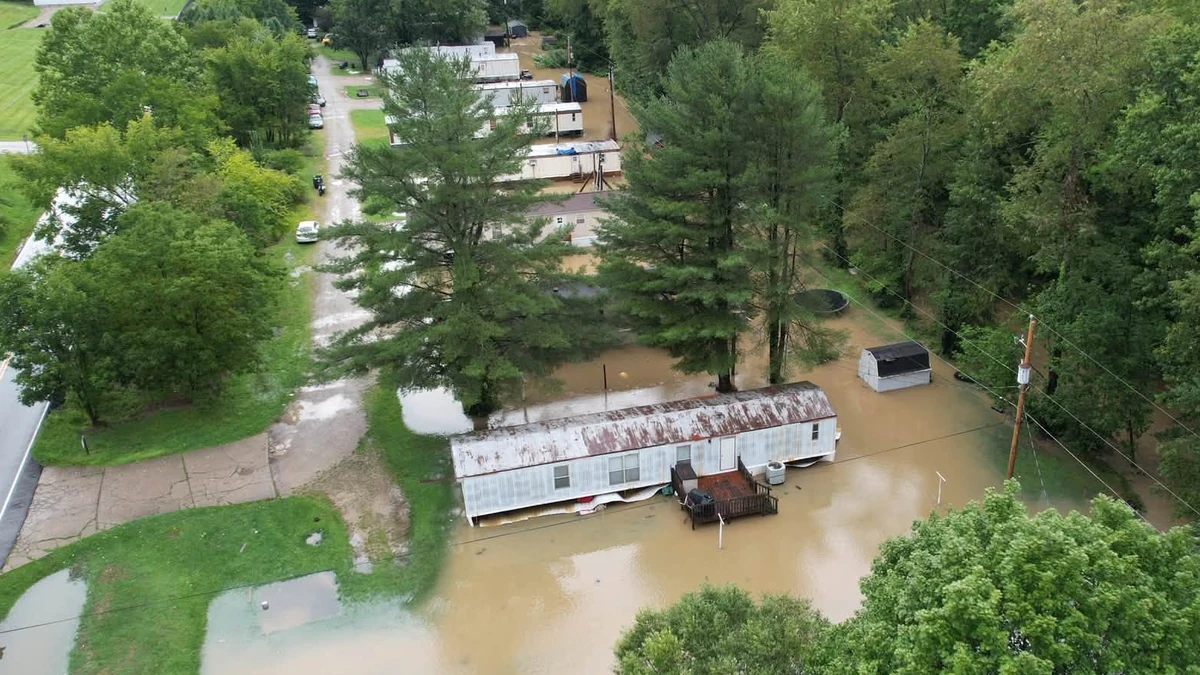
Flooding in New Lexington, Perry County, Ohio on August 11, 2026. Credit: Perry County Ohio
A person died in Roseville village during a medical emergency after flooded roads prevented first responders from reaching the individual on August 11, Governor DeWine confirmed.
The village of approximately 1 500 residents was nearly isolated by flooding, with only one road reported to be usable. State officials urged residents who remained in Roseville to leave while an evacuation route was available.
A State of Emergency has been declared for Perry and Muskingum counties, with the Ohio National Guard High Water Rescue Unit for Roseville and Crooksville being activated.

The deployment included 40 Ohio Army National Guard members assigned to assist response operations in the two counties.
Ohio Department of Natural Resources swift-water rescue personnel also conducted rescues in the affected area beginning during the morning of August 11.
At 17:16 EDT on August 11 (21:16 UTC on August 11), NWS Charleston said radar and automated rain gauges indicated that 127–203 mm (5–8 inches) of rain had fallen since midnight across central Perry County and northwestern Morgan County.
Numerous structures, vehicles and roads were flooded around New Lexington, Somerset, Crooksville, Junction City and nearby areas.
At 06:04 EDT on August 12 (10:04 UTC on August 12), flooding of creeks and streams continued across central Perry and northwestern Morgan counties. NWS said no additional rainfall was expected in that specific warning area, with the warning remaining in effect until 10:15 EDT (14:15 UTC).

A flood watch remained in effect across southeastern Ohio through the morning of August 14 as saturated soils and further thunderstorms could produce significant runoff and renewed flooding.
A separate NWS warning for parts of Athens, Morgan, Perry and Washington counties said 102-152 mm (4-6 inches) of rain had fallen.
At 17:50 EDT on August 11 (21:50 UTC on August 11), the automated gauge on Sunday Creek at Glouster stood at 4.94 m (16.2 feet), corresponding to moderate flooding.
Ohio Route 13 and several streets were flooded in Glouster, Trimble and Jacksonville. NWS reported 76–127 mm (3–5 inches) of rain in other warned parts of southeastern Ohio. Several roads remained closed in parts of Athens, Morgan, Perry and Washington counties early on August 12.

Flooding also continued across central Athens County, southwestern Morgan County and west-central Washington County, where numerous roads remained closed. The warning for those areas remained in effect until 18:00 EDT on August 12 (22:00 UTC on August 12).
At 03:45 EDT on August 12 (07:45 UTC on August 12), the Muskingum River at Beverly stood at 9.02 m (29.6 feet), above its 8.84 m (29 feet) flood stage.
NWS forecast the river to crest near 9.08 m (29.8 feet) during the morning before falling below flood stage late in the afternoon. The flood warning remained in effect through the evening of August 12.
At 03:15 EDT on August 12 (07:15 UTC on August 12), the Hocking River at Athens stood at 5.49 m (18 feet). NWS forecast the river to rise above its 6.10 m (20 feet) flood stage during the early afternoon and crest near 6.31 m (20.7 feet) that evening. The river was forecast to fall below flood stage on Thursday morning, with the warning remaining in effect through Thursday afternoon.
The Hocking River at Enterprise stood at 3.81 m (12.5 feet) at 05:00 EDT on August 12 (09:00 UTC on August 12), above its 3.66 m (12 feet) flood stage. NWS forecast the river to crest near 3.90 m (12.8 feet) during the morning before falling below flood stage late in the afternoon. The warning remained in effect through Wednesday evening.
The broader flood watch included Athens, Gallia, Jackson, Lawrence, Meigs, Morgan, Perry, Vinton and Washington counties in southeastern Ohio.
NWS said soils remained saturated, while creeks and streams were already running high. Additional rounds of thunderstorms through early on August 14 could produce heavy rainfall and renewed flash flooding.
References:
1 Governor DeWine Updates Ohioans on Severe Weather – Office of Ohio Gov. Mike DeWine – August 11, 2026.
2 Severe weather knocks out power in Illinois, Indiana and Ohio as ‘ring of fire’ strikes Midwest – AP – August 12, 2026
3 Flood Warning – NWS – August 12, 2026

I am an Assistant Editor and Severe Weather & Science Journalist at The Watchers, specializing in real-time severe weather coverage, geophysical event reporting, and research-driven scientific analysis. You can reach me at rishav(at)watchers(.)news.

Commenting rules and guidelines
We value the thoughts and opinions of our readers and welcome healthy discussions on our website. In order to maintain a respectful and positive community, we ask that all commenters follow these rules.