
NOAA confirms strengthening El Niño, with 81% chance of very strong conditions in October–December 2026
El Niño is present and strengthening across the central and eastern equatorial Pacific, the National Oceanic and Atmospheric Administration (NOAA) confirmed on August 3, 2027. Meanwhile, its July strength outlook gives an 81% chance of very strong conditions during October–December 2026. WMO’s August–October 2026 outlook also shows associated shifts in seasonal temperature and rainfall probabilities across multiple regions. NOAA maintains an El Niño Advisory.
El Niño is present and strengthening across the central and eastern equatorial Pacific, NOAA Climate Prediction Center (CPC) confirmed on August 3. An El Niño Advisory remains in effect, with NOAA assigning an 81% chance of very strong conditions during October–December 2026.
Currently, El Niño has a 97% chance of continuing through early Northern Hemisphere spring 2027. NOAA defines a very strong event as a Relative Oceanic Niño Index, or RONI, of at least 2°C (3.6°F).
RONI starts with the Niño 3.4 sea-surface temperature departure, subtracts the average tropical departure, adjusts the variance and applies a three-month running mean. NOAA listed the April–June 2026 RONI at 0.5°C (0.9°F), its operational El Niño threshold.
The agency warns that a stronger El Niño does not automatically produce larger weather and climate impacts. Greater strength raises the probability of some impacts but does not determine their magnitude.
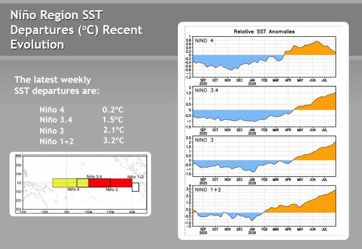
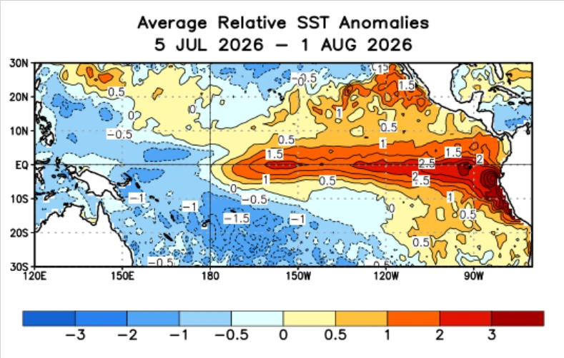
The latest weekly sea-surface temperature departures reached 3.2°C (5.8°F) in the Niño 1+2 region, 2.1°C (3.8°F) in Niño 3, 1.5°C (2.7°F) in Niño 3.4 and 0.2°C (0.4°F) in Niño 4. The strongest warming remained in the eastern equatorial Pacific, while the Niño 4 region farther west recorded a much smaller departure.
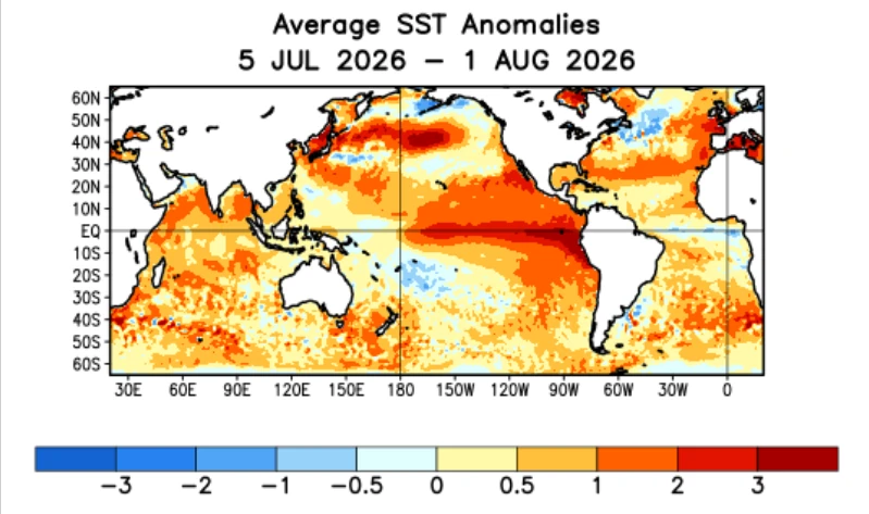
Above-average temperatures extended from the Date Line to the eastern Pacific during the four weeks ending August 1. Warming increased across parts of the east-central and eastern Pacific, while temperatures weakened relative to average in the west-central Pacific and near Indonesia.
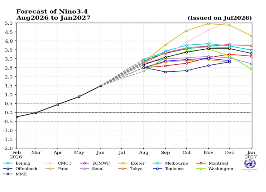
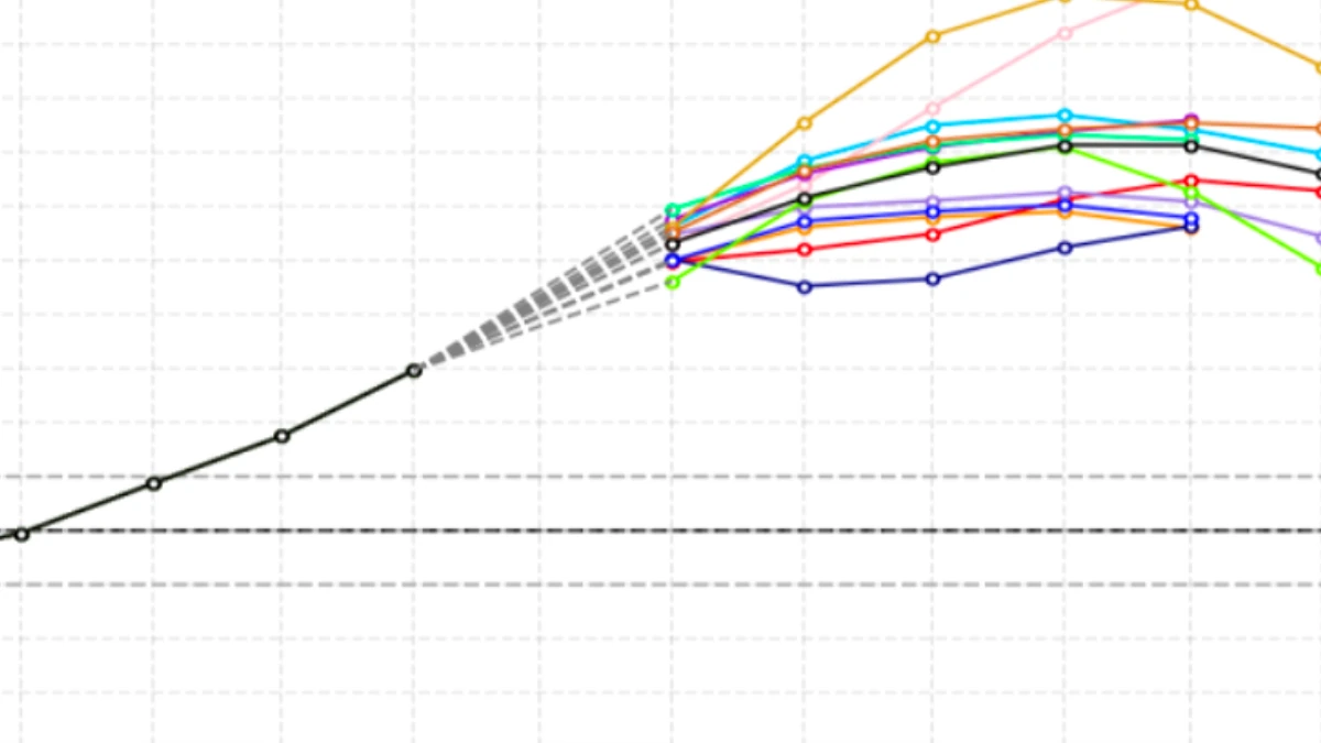
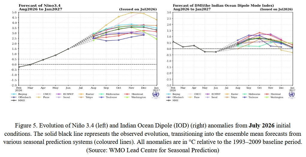
The World Meteorological Organization (WMO) reported a rapid rise in the Niño 3.4 anomaly during the Northern Hemisphere spring and early summer. The anomaly increased from 0.5°C (0.9°F) in April to 0.9°C (1.6°F) in May and 1.6°C (2.9°F) in June, based on the 1991–2020 average. The April–June mean was 1°C (1.8°F).
WMO’s multimodel forecast shows further strengthening during August–October 2026. The forecast Niño 3.4 mean rises from 2.7 ± 0.2°C (4.9 ± 0.4°F) in August to 3.1 ± 0.4°C (5.6 ± 0.7°F) in September and 3.4 ± 0.6°C (6.1 ± 1.1°F) in October. The three-month mean is forecast at 2.9 ± 0.4°C (5.2 ± 0.7°F), with the development trajectory reaching its highest point in November.
Above-normal temperatures are favored across most land areas north of 60°S during August–October. The main warm signals cover much of Africa, southern Europe, the Arabian Peninsula, the Indian subcontinent, eastern Asia, western North America below 60°N, Central America and the Caribbean.
Warm conditions are also favored across southern Africa, tropical and subtropical South America, New Zealand, and southern and central Australia.
The forecast signal is weaker over parts of northern Asia and northwestern and eastern North America. Below- to near-normal temperatures are favored over part of the North Atlantic, while below-normal conditions are forecast over the subtropical South Pacific between approximately 10°S and 30°S.
WMO favors above-normal rainfall across the central and eastern equatorial Pacific, the Greater Horn of Africa, parts of Central Asia and the northern Arabian Peninsula. Wetter-than-normal conditions are also favored over western North America south of approximately 45°N, southeastern South America and southern Europe.
Below-normal rainfall is favored across the Indian subcontinent, southern and eastern Australia, southern Central America, parts of the Caribbean, northwestern and northern coastal South America and northern Europe. The tropical Indian Ocean and equatorial Atlantic also carry a broad dry signal around the wetter central and eastern Pacific.
Model agreement is high or strong over the Indian subcontinent, Australia and parts of Central America. Agreement over Europe is lower, with wetter conditions favored in the south and drier conditions in the north.
NOAA reported above-average heat content in the upper 300 m (984 feet) of the equatorial Pacific. Positive subsurface temperature anomalies persisted across most of the basin and increased again from late May through July after declining from late April to late May.
A downwelling equatorial Kelvin wave was initiated during June 2026, one of four identified since December 2025. NOAA said downwelling and warming occur in the leading part of these waves and reported increasing positive subsurface temperature anomalies across the central and east-central Pacific.
Atmospheric circulation anomalies were consistent with El Niño by late July. Enhanced convection and precipitation extended from near the Date Line into the east-central equatorial Pacific, while suppressed convection was observed over Indonesia, the Philippines and Papua New Guinea.
Low-level westerly wind anomalies covered the western to east-central equatorial Pacific, with upper-level circulation anomalies also present.
It is worth mentioning that NOAA scheduled a change in the RONI dataset from ERSSTv5 to ERSSTv6 on August 3 because the National Centers for Environmental Information was discontinuing ERSSTv5. RONI values were expected to change slightly, while the OISSTv2.1 data used for weekly monitoring would remain unchanged. Any historical comparison or ranking must identify the index and dataset version used.
References:
1 ENSO: Recent Evolution, Current Status and Predictions – NOAA/CPC – August 3, 2026
2 Strong El Niño expected to intensify – WMO – July 31, 2026

Rishav Kothari is Editor-in-Chief of The Watchers, where he runs the newsroom and covers earthquakes, volcanoes, severe weather and space weather.
Earlier reporting
Nothing on Watchers was published in the last 24 hours. These are older articles.
- Winds high above the Arctic broke a 68-year record by collapsing in early November, and while the eastern US has already had a taste of the cold it shook loose, forecasters say a second wave could arrive around Thanksgiving weekend
- CPC posts a slight risk of heavy rain from the Gulf Coast to the Northeast urban corridor November 25-29, and a moderate risk of West Coast wind and Sierra snow on November 25
- Florida's east coast faces a moderate flash flood risk Wednesday through Friday, with 4 to 8 inches of rain forecast and the St. Johns River near Cocoa already in major flood at 17.13 feet
- Cyclone Akvan to make landfall between Nellore and Visakhapatnam around noon on November 20, IMD forecasts 120-130 km/h winds gusting to 145
