
Moderate risk of severe thunderstorms, EF3+ tornado threat forecast across Missouri and Illinois
Severe thunderstorms are forecast across the Mid-Mississippi Valley and Mid-South on April 27, 2026, with the Storm Prediction Center placing parts of Missouri and Illinois under a Moderate Risk (Level 4 of 5). Multiple strong tornadoes, including EF3+ intensity, are possible alongside damaging winds and large hail.

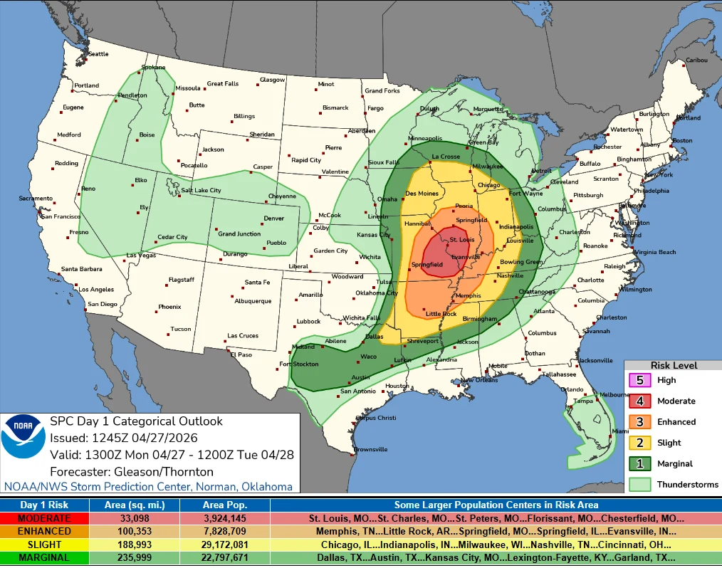
Convective Outlook valid 14:00 EDT on April 27 to 14:00 EDT on April 28, 2026. Credit: NWS/SPC
The Storm Prediction Center (SPC) has issued a Moderate Risk for severe thunderstorms across parts of central Missouri into southern Illinois, forecasting multiple intense supercells capable of producing EF3 or stronger tornadoes on April 27.
The most dangerous conditions are forecast to develop during the afternoon and evening, when a strongly unstable air mass combines with intense deep-layer wind shear.
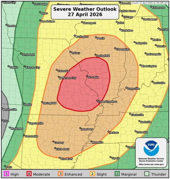
A broader Enhanced Risk extends across parts of Tennessee, Arkansas, Missouri, Indiana, and Illinois. Severe thunderstorms within this zone are expected to produce tornadoes, damaging winds, and hail, increasing the geographic footprint of the event across the Mid-South and Lower Mississippi Valley.
The severe weather setup is driven by a developing low-pressure system over southern Kansas lifting northeastward into the Upper Midwest, while a cold front advances eastward across the central United States. Ahead of the front, a surge of warm, moist air continues to feed into the region, maintaining the instability required for sustained thunderstorm development.
Ongoing morning thunderstorms across Missouri and nearby areas are shaping the position of surface boundaries that will influence where the highest tornado risk develops later in the day. Forecasters expect the most favorable conditions for discrete supercells to emerge south of early-day convection, where the atmosphere can destabilize more efficiently.
In addition to severe convective hazards, repeated rounds of thunderstorms may produce scattered flash flooding across parts of the Mid-Mississippi Valley and Mid-South. The Weather Prediction Center indicates that this pattern may continue over the next several days as the frontal boundary progresses southward.
References:
1 Day 1 Convective Outlook – NWS/SPC – April 27, 2026
2 Short Range Forecast Discussion – NWS/WPC – April 27, 2026

I am an Assistant Editor and Severe Weather & Science Journalist at The Watchers, specializing in real-time severe weather coverage, geophysical event reporting, and research-driven scientific analysis. You can reach me at rishav(at)watchers(.)news.
Commenting rules and guidelines
We value the thoughts and opinions of our readers and welcome healthy discussions on our website. In order to maintain a respectful and positive community, we ask that all commenters follow these rules.