
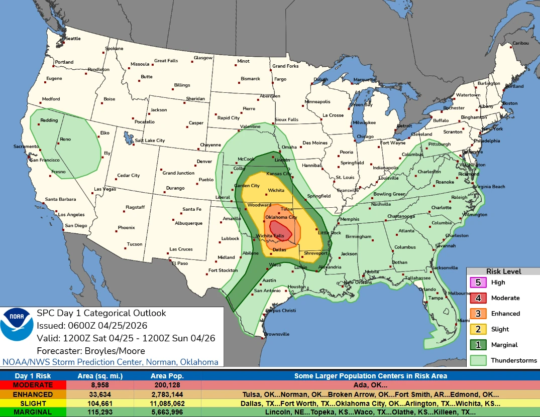
Moderate Risk issued for central and southeast Oklahoma as strong tornadoes and very large hail threaten southern Plains
NOAA’s Storm Prediction Center placed parts of central and southeast Oklahoma under a Moderate Risk for severe thunderstorms on April 25, 2026, with large to very large hail, tornadoes, and damaging winds forecast across parts of the southern Plains and Ark-La-Tex. Hailstones over 7.6 cm (3 inches) and strong tornadoes are possible during the afternoon and evening, where discrete supercells develop.

Moderate Risk of severe thunderstorms in central and southeastern Oklahoma on April 25, 2026. Credit: NOAA/NWS
A very active stretch of spring severe weather will continue this weekend across the Plains states and Midwest as a dryline and meandering frontal boundary interact with a very unstable airmass beneath a strong subtropical jet-stream, NWS forecaster Asherman noted early Saturday, April 25.
“Today, large to very large hail, tornadoes, and severe wind are likely as intense thunderstorms form,” Asherman said.
Storm Prediction Center (SPC) placed parts of central and southeast Oklahoma under a Moderate Risk for severe thunderstorms on Saturday, with large to very large hail, tornadoes, and damaging winds forecast across parts of the southern Plains and Ark-La-Tex.
The Day 1 outlook, issued at 06:00 UTC, is valid from 12:00 UTC on April 25 to 12:00 UTC on April 26. SPC said hailstones over 7.6 cm (3 inches) and strong tornadoes are possible where discrete supercells develop during the afternoon and evening.
Storms are forecast to form along two boundaries — an outflow boundary moving north from north Texas into southern Oklahoma, and a front moving into central Oklahoma.
The severe threat is then anticipated to shift into the Central Plains tomorrow as a lee-side cyclone takes shape in Colorado, leading to another round of storms capable of all modes of severe weather.
Severe weather will continue Monday, April 27, over the Midwest as the dynamic lee-side cyclone leaves the Plains, leading to a swath of severe thunderstorms along a cold front roughly along a Quad-Cities to Memphis line.
Although severe weather will be the main headline with these thunderstorms over the next few days, they will also be capable of producing high rainfall rates and isolated flash flooding.
References:
1 Day 1 Convective Outlook – NWS/SPC – April 25, 2026
2 Short Range Forecast Discussion – NWS/WPC – April 25, 2026

I am an Assistant Editor and Severe Weather & Science Journalist at The Watchers, specializing in real-time severe weather coverage, geophysical event reporting, and research-driven scientific analysis. You can reach me at rishav(at)watchers(.)news.
Commenting rules and guidelines
We value the thoughts and opinions of our readers and welcome healthy discussions on our website. In order to maintain a respectful and positive community, we ask that all commenters follow these rules.