
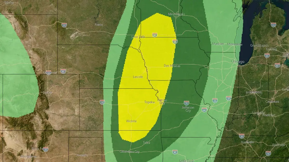
Severe thunderstorms forecast from northern Oklahoma to southern Minnesota on April 23
Severe storms are expected to develop from northern Oklahoma into southern Minnesota on April 23, 2026, bringing a risk of large to very large hail and damaging winds. A few tornadoes are possible, primarily during the early stages of storm development, according to the NOAA Storm Prediction Center.
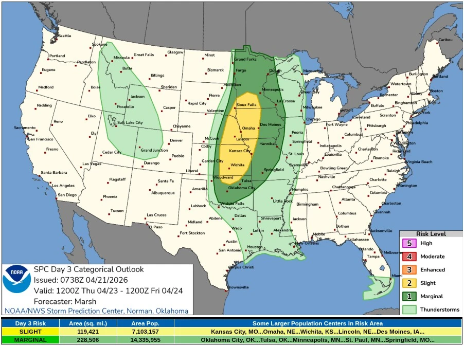
Convective outlook valid 14:00 EDT on April 23 to 14:00 EDT on April 24, 2026. Credit: NWS/SPC
Severe thunderstorms are forecast to develop across a broad corridor from northern Oklahoma into southern Minnesota on Thursday, April 23, as a complex synoptic pattern supports convective development across the central United States.
The NOAA Storm Prediction Center (SPC) has outlined a Slight Risk (Level 2/5) for this region, indicating the potential for organized severe storms capable of producing large hail, damaging winds, and a few tornadoes.
A broad long-wave trough will remain anchored across the western United States, maintaining large-scale support for ascent over the Plains. While the primary shortwave trough is forecast to lift northward into Canada, a secondary, lower-amplitude disturbance is expected to approach the southern Plains later in the period, extending convective potential into the overnight hours.
At the surface, a Pacific cold front and dryline are forecast to move eastward into the central Plains. A secondary surface low is expected to develop near the triple point region of northwest Oklahoma and southwest Kansas. This feature is expected to act as a focal point for storm initiation and may define the southern extent of the more organized severe weather threat.
Thunderstorm development is expected along the advancing cold front and dryline from eastern Nebraska into western Iowa before expanding both northward and southward. Forecast soundings indicate mixed-layer convective available potential energy (MUCAPE) values of 1 500–2 500 J/kg, combined with deep-layer shear, supporting the development of supercell structures during the initial stages of convection.
Early in the convective cycle, a few tornadoes may be possible, particularly with discrete storms. As storm interactions increase and environmental wind profiles remain largely unidirectional, storms are expected to evolve into clusters or linear segments. This transition will favor damaging winds and large hail as the dominant hazards through the latter part of the day.
Farther south, convective initiation along the dryline remains uncertain due to stronger capping. However, if storms are able to develop in this environment, they will encounter higher instability, with MUCAPE values between 2 000 and 3 000 J/kg and sufficient vertical shear to support supercells. Any discrete storms that form in this region may produce very large hail.
During the overnight period into early April 24, a secondary disturbance is expected to move into the region, steepening mid-level lapse rates and increasing instability. Additional thunderstorm development is possible during this time, although the severe potential remains uncertain due to increasing convective inhibition and the timing of the forcing. Strong vertical shear may still support a hail and wind threat with any storms that develop overnight.
Across northern Minnesota and adjacent areas, lower moisture and instability are expected to limit the overall severity of storms. However, proximity to the upper-level wave may support a localized wind threat with any thunderstorms that form.
The forecast follows a severe weather episode across parts of the central United States on April 17 that generated 90 tornado reports across multiple states, including Minnesota, Wisconsin, Illinois, Iowa, Missouri, Kansas, and Oklahoma. Several tornadoes have been rated up to EF-3 based on initial damage surveys.
References:
1 Forecast Discussion Day 3 Convective Outlook – NWS/SPC – April 21, 2026
I'm a dedicated researcher, journalist, and editor at The Watchers. With over 20 years of experience in the media industry, I specialize in hard science news, focusing on extreme weather, seismic and volcanic activity, space weather, and astronomy, including near-Earth objects and planetary defense strategies. You can reach me at teo /at/ watchers.news.
Commenting rules and guidelines
We value the thoughts and opinions of our readers and welcome healthy discussions on our website. In order to maintain a respectful and positive community, we ask that all commenters follow these rules.