
Late-season winter storm forecast to bring ice, snow, and severe weather to Upper Midwest and Great Lakes
A late-season winter storm combined with severe convective activity will affect the Upper Midwest and Great Lakes from April 1–3, 2026, producing heavy snow, sleet, freezing rain, and thunderstorms. The system is expected to generate hazardous ice accumulation and support severe storms capable of damaging winds, hail, and tornadoes.
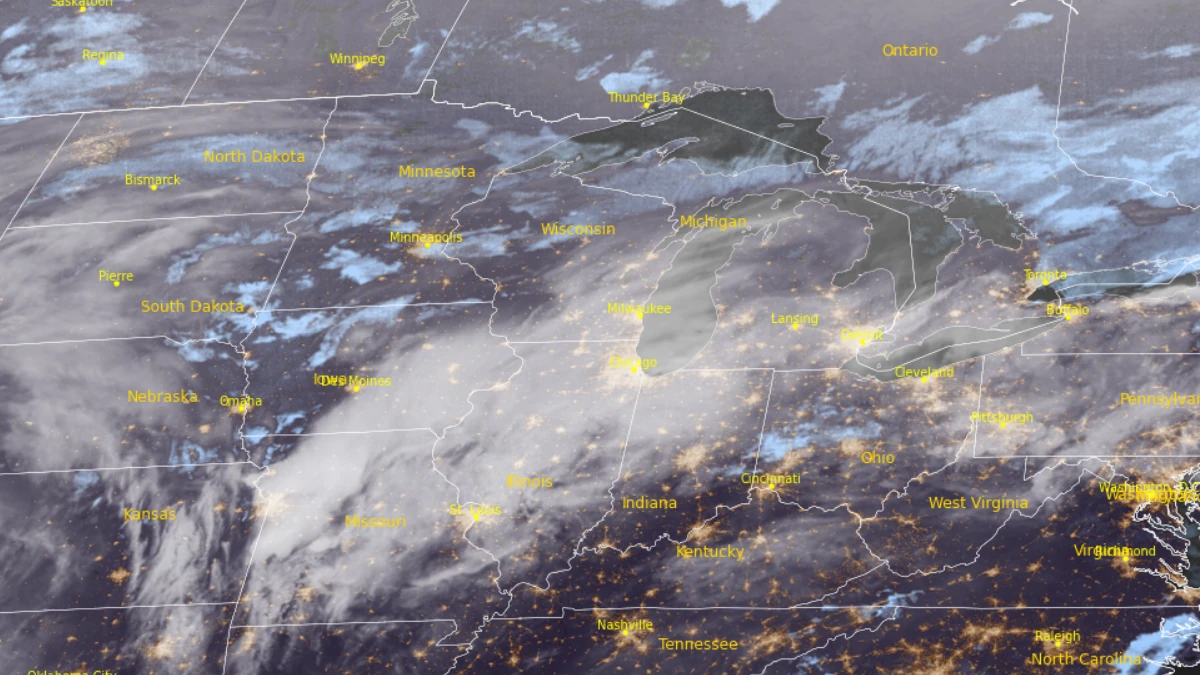
Satellite image of the Northern Plains and the Great Lakes region at 09:40 UTC on April 1, 2026. Credit: NOAA/GOES-19, RAMMB/CIRA, The Watchers
A developing low-pressure system over the Southern Plains is forecast to move northeastward into the Upper Great Lakes between April 1 and 3, producing a multi-hazard event across Minnesota, Wisconsin, and Michigan.
The system will strengthen as it tracks northeast, generating a combination of heavy snow, freezing rain, and severe thunderstorms across distinct but overlapping regions.
Freezing rain is expected to be the most significant hazard within a corridor extending from southern Minnesota through central Wisconsin into northern Michigan, with the most hazardous conditions developing overnight April 1 into April 2 and continuing into April 3.
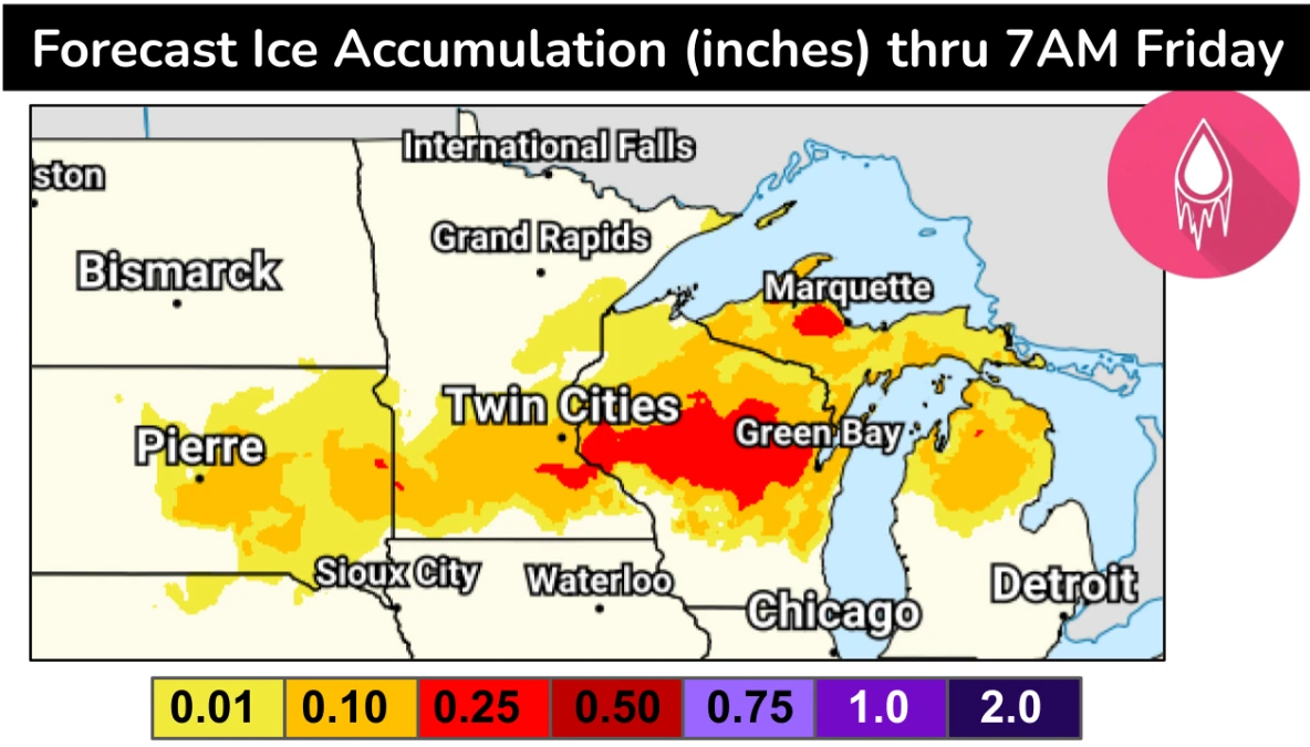
Forecast ice accretions range between 2.5 and 6.4 mm (0.1 and 0.25 inches), with localized amounts approaching 12.7 mm (0.5 inches). These levels are sufficient to produce hazardous travel conditions and may lead to localized infrastructure impacts, particularly where ice accumulation approaches higher thresholds.
Heavy snow will develop across the Northern Plains late April 1 and intensify on April 2 as the system deepens, spreading into northern portions of Minnesota. Snowfall totals of 75–150 mm (3–6 inches) are likely, with higher localized totals being possible.
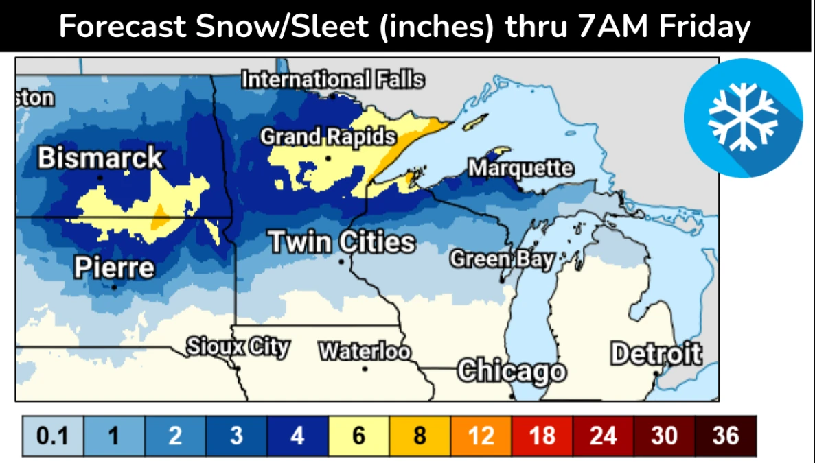
Snow will remain the dominant precipitation type across the Dakotas and northern Minnesota, while a transition zone of mixed precipitation, including sleet, is expected further south and east into central Minnesota and northern Wisconsin.
South of the winter weather zone, the system will support severe convective development within a strongly sheared and moisture-rich environment.
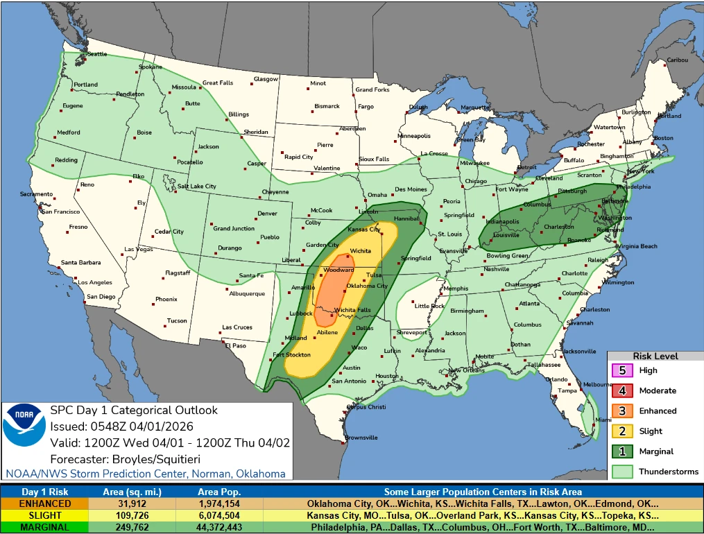
On April 1, severe thunderstorms are expected across the Central and Southern Plains, where an Enhanced Risk (level 3/5) is in place.
Moderate to strong instability and strengthening wind fields will support supercells capable of producing damaging wind gusts, large hail exceeding 5 cm (2 inches), and tornadoes, including the potential for strong tornadoes.
A strengthening low-level jet of approximately 85–100 km/h (55–60 mph) will transport moisture northward into the Midwest and Great Lakes, supporting further convective development on April 2.
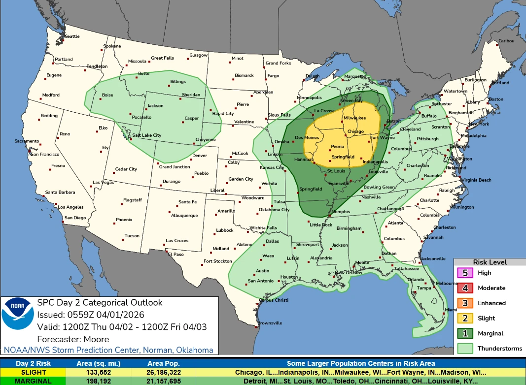
As the system advances northeastward, a Slight Risk (level 2/5) of severe thunderstorms extends into parts of Wisconsin, Illinois, and Michigan. Organized convective lines and semi-discrete cells are expected to develop, with damaging winds, hail, and a few tornadoes possible. Multiple rounds of convection, including redevelopment along the advancing cold front, may enhance the regional severe weather threat.
In addition to winter and severe weather hazards, the system will bring moderate to heavy rainfall across parts of the mid-Mississippi Valley and Central and Southern Plains. A Slight Risk (level 2/4) of excessive rainfall is in place, with localized flash flooding possible, particularly in urban areas, road networks, and low-lying terrain.
References:
1 Short Range Forecast Discussion – NWS/WPC – April 1, 2026
2 Day 1 Convective Outlook – NOAA/SPC – April 1, 2026
3 Day 2 Convective Outlook – NOAA/SPC – April 1, 2026

I am an Assistant Editor and Severe Weather & Science Journalist at The Watchers, specializing in real-time severe weather coverage, geophysical event reporting, and research-driven scientific analysis. You can reach me at rishav(at)watchers(.)news.
Commenting rules and guidelines
We value the thoughts and opinions of our readers and welcome healthy discussions on our website. In order to maintain a respectful and positive community, we ask that all commenters follow these rules.