
Red Flag Warnings issued from the Plains to the Southeast under critical fire weather conditions
Red Flag Warnings are in effect across parts of the Plains, Upper Midwest, and Southeast United States on March 28, 2026, as the National Weather Service (NWS) warns of critical fire weather conditions driven by strong winds, low relative humidity, and dry fuels. Wind gusts up to 80 km/h (50 mph) and humidity levels as low as 10–20% are expected to promote rapid fire ignition and spread. Outdoor burning is strongly discouraged across all warned regions.
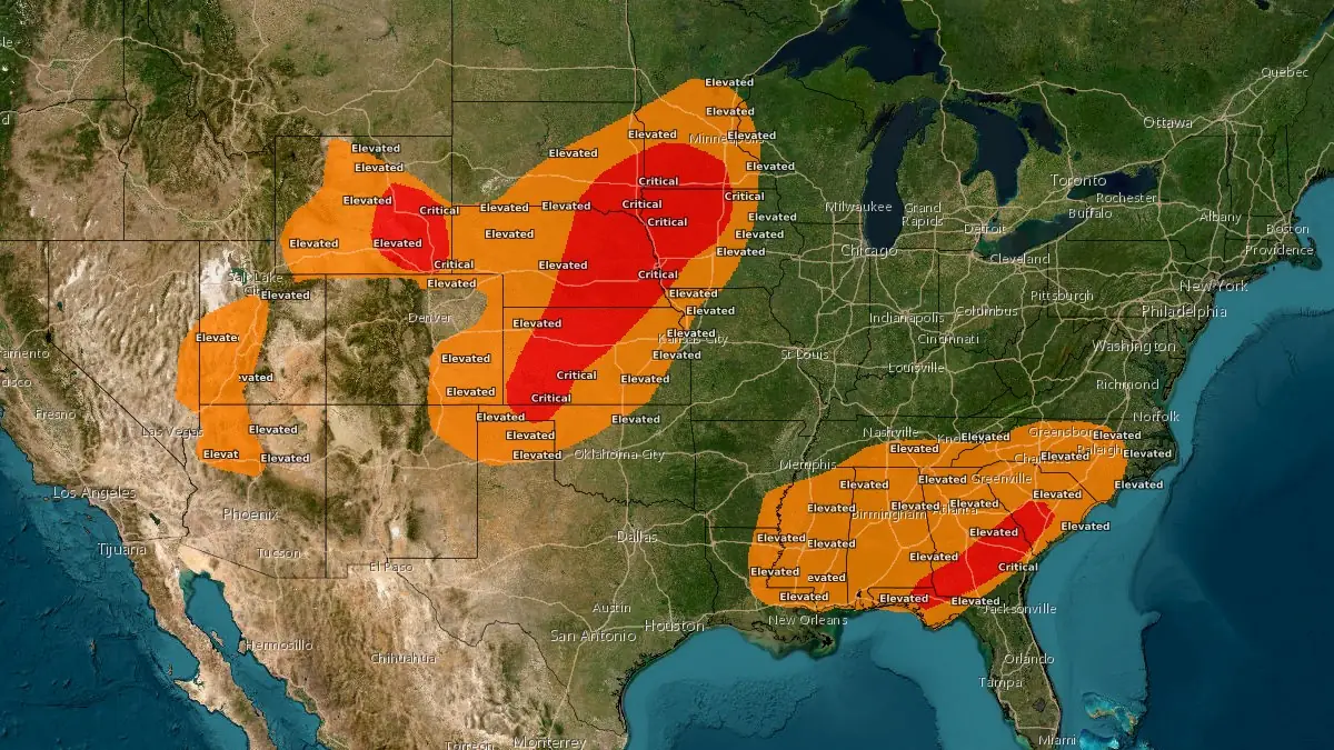
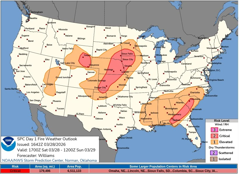
Critical Fire Weather map for March 28, 2026. Credit: NWS/SPC
A post-frontal air mass moving across the central and eastern United States is generating a combination of strong winds and critically low humidity, creating favorable conditions for wildfire ignition and rapid spread.
Wind gusts of 40–80 km/h (25–50 mph) are forecast, with relative humidity dropping below 20% at times, particularly across the Plains and parts of the Southeast.
Strong winds and critically low humidity, along with dormant vegetation and dry surface fuels, increase fire susceptibility. Any fires that develop under these conditions are likely to spread rapidly and become difficult to control, prompting the issuance of Red Flag Warnings across multiple forecast offices.
The Storm Prediction Center’s Day 1 Fire Weather Outlook identified three separate Critical fire weather areas on March 28, covering southeastern Wyoming, parts of the central and northern Great Plains, and a Southeast corridor from southern South Carolina through southern Georgia into the Florida Panhandle.
The broadest Plains corridor extended from the Oklahoma Panhandle northeastward into parts of Kansas, Nebraska, southeastern South Dakota, southwestern Minnesota, and western Iowa.
In total, the SPC placed about 465 000 km2 (179 500 mi2) under Critical fire weather conditions, covering an estimated 6.5 million people.
In Minnesota, Red Flag Warnings have been issued across central, southern, and western portions of the state, with warnings in effect until 19:00–21:00 CDT on March 28. Southwest winds of 30–50 km/h (20–30 mph), gusting up to 65–72 km/h (40–45 mph), combined with relative humidity as low as 16–19%, are expected to support rapid fire spread.
Kansas is under widespread Red Flag Warnings from 11:00 to 22:00 CDT, with south winds of 25–50 km/h (15–30 mph) and gusts up to 72 km/h (45 mph). Relative humidity values between 10% and 20%, combined with dry, dormant fuels, are expected to enhance fire spread potential across large parts of the state.
Across eastern Nebraska, southeast South Dakota, northwest Iowa, and adjacent areas, Red Flag Warnings remain in effect until 21:00–22:00 CDT. Winds are forecast at 40–55 km/h (25–35 mph) with gusts up to 80 km/h (50 mph), while relative humidity may drop as low as 10–13%.
This may also generate blowing dust, reducing visibility in exposed areas.
Kansas is under widespread Red Flag Warnings from 11:00 to 22:00 CDT, with south winds of 25–50 km/h (15–30 mph) and gusts up to 72 km/h (45 mph). Relative humidity values between 10–20% and dry, dormant fuels are expected to enhance fire spread potential across the state.
In Oklahoma, warnings are in effect from 11:00 to 19:00 CDT across northern and western areas, where relative humidity may fall to around 12% alongside gusts up to 50 km/h (30 mph). Dry vegetation and elevated fuel readiness further increase the likelihood of rapid fire growth.
Central and northern Alabama are under Red Flag Warnings until 19:00 CDT, with northeasterly winds of 15–25 km/h (10–15 mph) and gusts up to 40–50 km/h (25–30 mph). Relative humidity values as low as 17–21% are expected to support critical fire weather conditions across the region.
Warnings extend across portions of Mississippi, northeast Louisiana, and southeast Arkansas until 19:00 CDT, where northeast winds of 15–30 km/h (10–20 mph) and relative humidity near 20% are forecast. In Louisiana, a Fire Weather Watch has also been issued for March 29.
Large portions of Georgia, South Carolina, and North Carolina are under Red Flag Warnings until 23:00 EDT, including the western Carolinas and northeast Georgia. Winds of 15–25 km/h (10–15 mph), gusting up to 50 km/h (30 mph), combined with relative humidity as low as 15%, are expected to sustain critical fire conditions across the region.
In the western United States, Red Flag Warnings remain in effect across southeast Wyoming through 21:00 MDT on March 31, with additional warnings extending into the Nebraska Panhandle from March 29 to March 31.
Winds of 25–40 km/h (15–25 mph), gusting up to 70 km/h (45 mph), combined with relative humidity between 8% and 15%, are expected to maintain prolonged fire weather concerns. Isolated dry lightning associated with virga showers may further increase ignition risk.
References:
1 Short Range Forecast Discussion – NWS/WPC – March 28, 2026
2 Day 1 Fire Weather Outlook – NWS/SPC – March 28, 2026

I am an Assistant Editor and Severe Weather & Science Journalist at The Watchers, specializing in real-time severe weather coverage, geophysical event reporting, and research-driven scientific analysis. You can reach me at rishav(at)watchers(.)news.
Commenting rules and guidelines
We value the thoughts and opinions of our readers and welcome healthy discussions on our website. In order to maintain a respectful and positive community, we ask that all commenters follow these rules.