
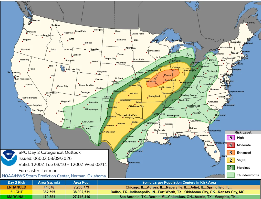
Enhanced Risk of severe thunderstorms for parts of Missouri, Iowa, Illinois and Indiana on March 10
An Enhanced Risk of severe thunderstorms is in effect for parts of the Midwest on March 10, 2026, including northeast Missouri, southeast Iowa, northern and central Illinois, and northwest Indiana. The forecast environment supports the development of supercells and organized thunderstorm clusters capable of producing tornadoes, damaging wind gusts, and large hail during the afternoon and evening hours.
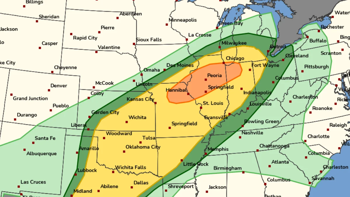
Image credit: NOAA/SPC
The Storm Prediction Center (SPC) has issued an Enhanced Risk (level 3/5) for severe thunderstorms across portions of the Midwest for March 10.
Forecast hazards include damaging winds, large hail, and tornadoes, with storms expected to develop during the afternoon and evening hours.
The areas under the highest risk include northeast Missouri, far southeast Iowa, northern and central Illinois, and northwest Indiana.
The risk is due to a large-scale storm system moving eastward across the central United States. A split-flow upper-level pattern is expected to establish favorable conditions for severe convection from the southern Plains into the Midwest, according to SPC.
One upper-level trough is forecast to move from the southwestern United States toward the southern High Plains, while a second trough deepens across the northern Plains and Upper Midwest. The interaction of these features will produce strong southwesterly winds aloft and large-scale atmospheric lift across the Mid-Mississippi Valley.
These upper-level dynamics could interact with increasing low-level moisture transported northward from the Gulf of Mexico. The combination of moisture, atmospheric instability, and strong vertical wind shear creates an environment supportive of organized thunderstorms.
Initial storm development may occur as discrete supercells capable of producing tornadoes and large hail. As storms evolve and merge during the evening hours, they may organize into clusters or lines capable of producing widespread damaging wind gusts.
Additional severe thunderstorm potential is also forecast across parts of the southern Plains, including Texas and Oklahoma, as the storm system moves eastward across the central United States.
The corridor from northern Missouri into central Illinois and northwest Indiana remains the primary focus of the Enhanced Risk area due to an overlap of instability, moisture, and wind shear being forecast over the region. This region also lies near a frontal boundary that would support storm development.
Damaging wind gusts exceeding 90–110 km/h (55–70 mph) are possible with the strongest storms. Large hail measuring 2.5 cm (1 inch) in diameter or greater may also occur, particularly with supercell thunderstorms. Isolated tornadoes cannot be ruled out if storms remain discrete during the early stages of development.
Heavy rainfall may accompany some storms, especially where thunderstorms occur over the same areas, causing localized flash floods in urban areas or locations with poor drainage.
Forecast uncertainty remains regarding the precise placement of the warm front and the timing of storm initiation. Small shifts in these features can significantly alter the location and intensity of severe storms. Meteorologists will continue to monitor mesoscale developments as the event approaches.

I am an Assistant Editor and Severe Weather & Science Journalist at The Watchers, specializing in real-time severe weather coverage, geophysical event reporting, and research-driven scientific analysis. You can reach me at rishav(at)watchers(.)news.
Commenting rules and guidelines
We value the thoughts and opinions of our readers and welcome healthy discussions on our website. In order to maintain a respectful and positive community, we ask that all commenters follow these rules.