
Record-breaking February temperatures spread across France
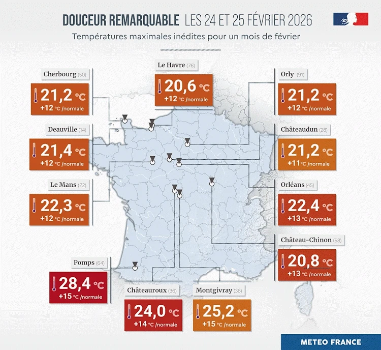
Temperatures in France reached levels typical of May on February 25–26, 2026, breaking multiple February records, according to Météo-France. The highest readings occurred in the southwest, where Pomps (Pyrénées-Atlantiques) reached 28.4°C (83.1°F) and Orthez (Pyrénées-Atlantiques) 28.3°C (82.9°F), about 14°C (25°F) above normal. Several other stations also registered new monthly records.

Image credit: Météo France
After weeks of rainy weather and the highest soil moisture since 1959, France entered a remarkable warm phase on February 25, when temperatures climbed to levels usually seen in late spring.
The national meteorological agency Météo-France confirmed multiple monthly records for February in the southwest, describing the event as “temperatures worthy of May.”
In the Pyrénées-Atlantiques department, Pomps recorded 28.4°C (83.1°F), surpassing the previous record of 28.2°C (82.8°F) set on February 27, 2019. Orthez recorded 28.3°C (82.9°F), beating its 2020 record of 27.1°C (80.8°F), about 14°C (25°F) above the seasonal norm. Farther east, Cérizols (Ariège) reported 24.6°C (76.3°F) and Lavaur (Tarn) 24.1°C (75.4°F), both setting new local records for the month.
Early on February 26, unusually mild overnight conditions were also recorded, including 13.1°C (55.6°F) in Montredon-Labessonnie (Tarn), exceeding the previous February night-time record of 11.5°C (52.7°F) set in 2024.
The warmth extended northward during the day, with forecast highs of 21°C (70°F) in Bourges (Cher), 20°C (68°F) in Paris, 19°C (66°F) in Rennes, and 18°C (64°F) in Lille, 8–11°C (14–20°F) above normal values for late winter.
Météo-France noted that temperatures, already high for the season, were climbing further between February 25–26 as the air mass responsible for the anomaly expanded toward central and northern France.
According to Agence France-Presse, Biarritz reached 27°C (80.6°F) and Pau 26°C (78.8°F), continuing the anomaly across the southwest. Values above 25°C (77°F) were measured at several stations.
The warm spell followed unprecedented 40 consecutive days of rain across the country, and one of France’s wettest February periods on record.

I’m a science journalist and researcher at The Watchers, contributing to the Epicenter edition, where I cover peer-reviewed scientific research and emerging discoveries across Earth and space sciences. With a background in astronomy and a passion for environmental science, I’ve worked in shark and coral conservation in Fiji, conducting reef and shark-behavior research, contributing to mangrove restoration, and earning PADI Open Water and Coral Reef Certifications. I bring a blend of scientific rigor and storytelling to illuminate the discoveries shaping our planet and beyond.
HA! They got us! All the reds and ambers and HOTTEST EVER!
Look at the numbers and where these stations are. Critically think. No! This is not anomalous at all.
Sheltered spots in London on warm days seeing equivalent figures end of February… 35 years ago.
Yes, the rain has been interesting, did you notice the connection globally after the January aurora event? It was the same pattern from the Southern Ocean with NZ too. Deepening, persisted low-pressure systems.
That 28c in Pomps a Foehn-effect contribution btw? The entire country was under an African long-fetch southerly flow, much of UK influenced by same regime, perhaps similarly biased coverage from there.
Might we review anomalous precipitation flooding (tragedy acknowledgement) and humidity globally trends, can we find an article pulling this together? From where are the provoking energies flowing, something looking and questioning deeply probably multi-disciplinary, rigorously bias-checked. Did the Atlantic have another warm pulse like mid-2023?
Are we not seeing a trend of increasing meridional flow over the past decades? Warm to hot; equatorial to polar. Entropy.