
Valentine’s Day weekend storm to bring widespread heavy rain to the southern United States
A developing storm system is forecast to bring widespread rain and thunderstorms to the south-central and southeastern United States from Friday, February 13, 2026, through Valentine’s Day weekend, with localized flooding possible where heavier rainfall occurs. The system is expected to track eastward from the Plains into the lower Mississippi Valley and Southeast between February 13 and February 15, affecting travel and outdoor activities across a large portion of the region.
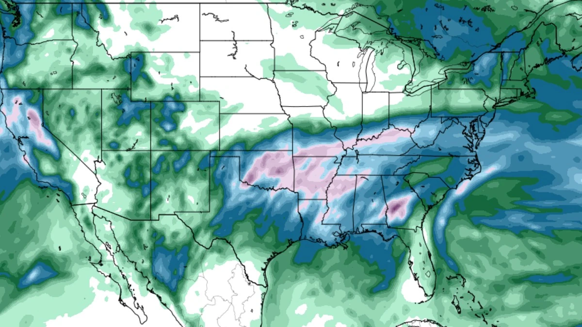
GFS Total Accumulated Precipitation model from 00:00 UTC on February 10 to 06:00 UTC on February 16, 2026. Credit: GFS, TropicalTidbits
A large storm system is forecast to develop over the South Central states late this week and move eastward across the lower Mississippi Valley and southeastern United States during Valentine’s Day weekend, bringing widespread rainfall and thunderstorms to much of the region.
Forecast guidance indicates precipitation will fall mainly as rain across the southern tier, with winter weather limited to the storm’s northern edge.
Rainfall totals of 25–100 mm (1–4 inches) are expected from parts of Texas and Oklahoma eastward through Louisiana, Mississippi, Alabama, Georgia, and the Carolinas from Friday through Sunday. Localized rainfall totals may approach 150 mm (6 inches) where thunderstorms repeatedly move over the same areas, particularly across portions of the Gulf Coast and interior Southeast.
Rainfall of this magnitude over a 24–48-hour period is not expected to cause widespread river flooding but may result in minor flooding in urban areas, low-lying locations, and neighborhoods with poor drainage. Small streams could respond quickly where rainfall rates increase during periods of heavier thunderstorms.
Soil moisture conditions across the region vary considerably, ranging from adequate to exceptional drought, according to recent drought assessments cited by AccuWeather. As a result, runoff efficiency is expected to vary by location, with localized flooding more likely when heavy rain occurs over a short period.
The most active period for thunderstorms is forecast to occur on Saturday, February 14, with the highest coverage expected from Louisiana and Arkansas eastward through Mississippi and Alabama, with activity potentially extending into Tennessee.
While severe weather is less common during winter, forecasters indicate that sufficient Gulf moisture and storm dynamics could support a few stronger thunderstorms in the southern states.
Above-average temperatures across much of the eastern United States are expected to support a rain-dominant outcome across the South as the storm moves through. Forecast highs across the southern Plains and Southeast are expected to range from the 16–21°C (60s to low 70s°F), limiting the potential for snow or ice outside of the system’s northern fringe.
Some uncertainty remains regarding the storm’s eventual track and rate of intensification. A quicker reorganization or a more northerly path toward the Great Lakes could shift heavier rainfall northward while reducing totals across parts of the Southeast, while increasing the risk of wintry weather farther north.
The developing system follows a clipper moving through the Interior Northeast earlier in the week and coincides with an active pattern in the western United States, where a Pacific system is bringing rain to lower elevations and mountain snow to higher terrain, according to the National Weather Service Weather Prediction Center.
References:
1 Short Range Public Discussion – NWS/WPC – February 10, 2026
2 Upcoming Valentine’s Day storm to bring drenching rain to southern US – AccuWeather – February 10, 2026
I'm a dedicated researcher, journalist, and editor at The Watchers. With over 20 years of experience in the media industry, I specialize in hard science news, focusing on extreme weather, seismic and volcanic activity, space weather, and astronomy, including near-Earth objects and planetary defense strategies. You can reach me at teo /at/ watchers.news.
Commenting rules and guidelines
We value the thoughts and opinions of our readers and welcome healthy discussions on our website. In order to maintain a respectful and positive community, we ask that all commenters follow these rules.