
Beneficial Sierra Nevada snowfall expected as weak atmospheric river moves through California
A short-duration atmospheric river is forecast to impact California from Tuesday, February 10, through Thursday, February 12, 2026, bringing low-elevation rainfall and significant snowfall at higher elevations, particularly across the Sierra Nevada. Forecast guidance indicates the event will be short-lived, with impacts expected to be largely beneficial for regional snowpack rather than flood-producing.
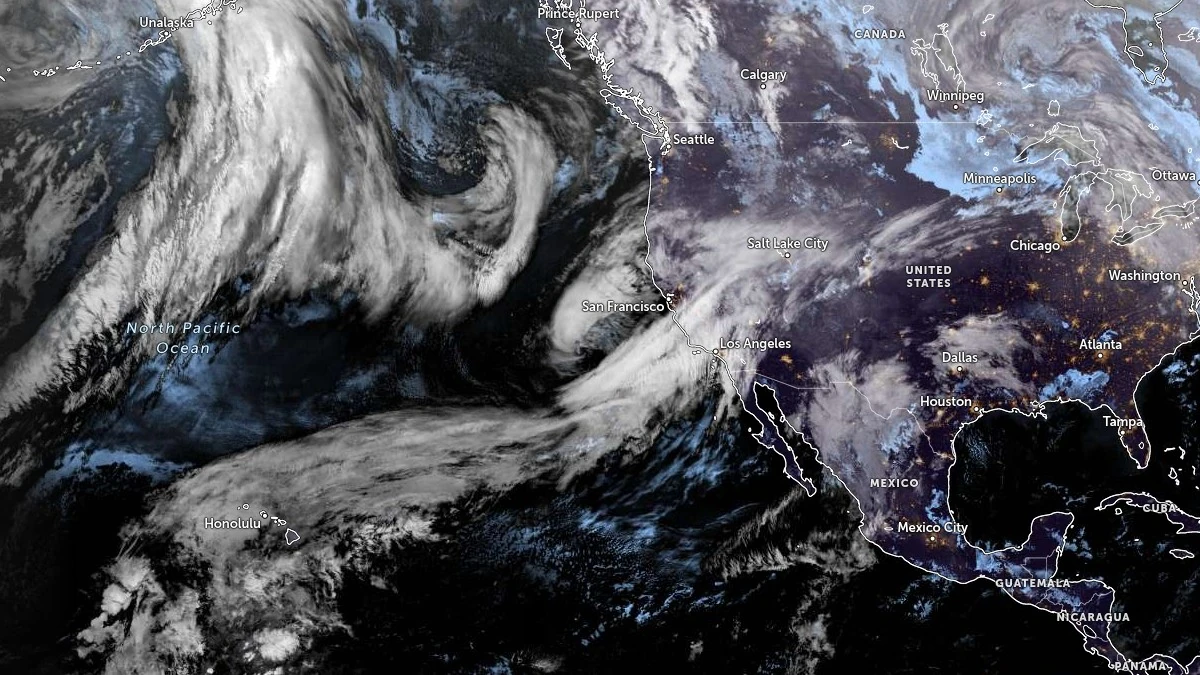
Atmospheric river developing in the Pacific Ocean. Satellite image acquired at 08:40 UTC on February 10, 2026. Credit: NOAA/GOES-West, Zoom Earth, The Watchers
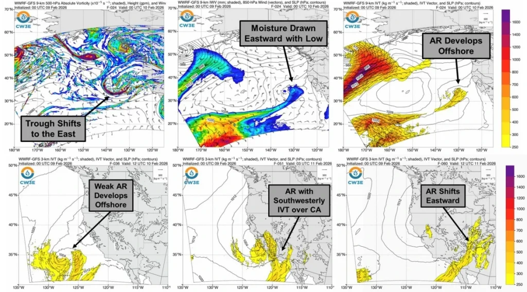
A weak atmospheric river is forecast to impact California from Tuesday, February 10, through Thursday, February 12, 2026, as a short-lived plume of subtropical moisture moves inland ahead of a mid-level low and associated trough.
Forecast guidance indicates the system will first make landfall in Northern California before shifting southward along the coast into Southern California.
Integrated vapor transport values are forecast to reach approximately 250–500 kg m⁻¹ s⁻¹ at times along portions of central and southern coastal California. Ensemble diagnostics classify the event primarily as AR0, due to the limited duration of less than 24 hours rather than sustained moisture transport.
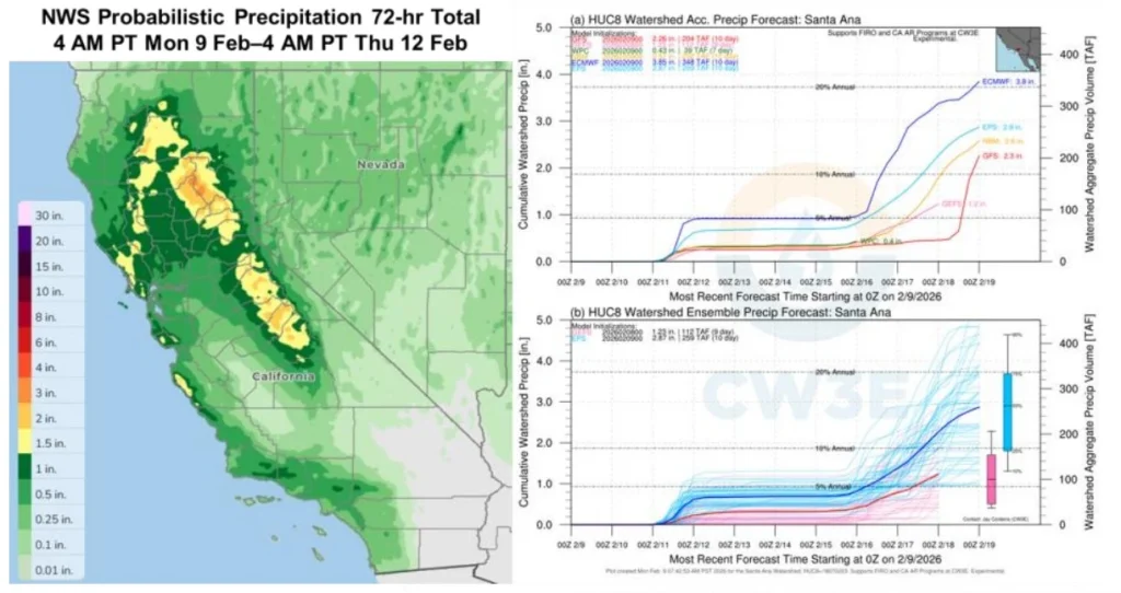
Precipitation associated with the system is expected to remain moderate at lower elevations, with the National Weather Service Weather Prediction Center (WPC) forecasting 72-hour totals of about 38–89 mm (1.5–3.5 inches) across the Sierra Nevada, 25–51 mm (1–2 inches) over the central California Coast Ranges, and 13–38 mm (0.5–1.5 inches) across the Transverse Ranges for the period ending early Thursday.
Freezing levels over the Sierra Nevada are forecast to lower to approximately 1 500–2 100 m (5 000–7 000 feet) as the system moves through the region, favoring snow rather than rain at higher elevations. Probabilistic guidance indicates 72-hour snowfall totals of roughly 30–91 cm (12–36 inches) along portions of the Sierra Nevada.
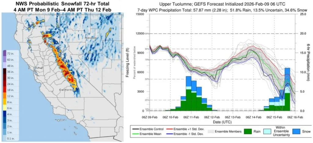
The snowfall will contribute to regional snowpack, which remains below normal for early February. State water data indicate the Sierra Nevada snowpack is currently near 50% of normal, making additional accumulation from this event beneficial for seasonal water resources.
Hydrologic impacts are expected to be limited due to the short duration of the atmospheric river and relatively modest rainfall totals.
Forecasters do not indicate widespread flooding concerns, with impacts instead focused on high-elevation snowfall and potential travel difficulties over mountain passes during periods of heavier snow.
Forecast guidance also suggests the potential for additional atmospheric river activity along the US West Coast later in the week. Considerable uncertainty remains regarding the timing and magnitude of any subsequent systems, and forecasters note that future impacts will depend on the persistence and duration of moisture transport toward the region.
References:
1 Quick Look at the AR Forecast to Impact California Early this Week – CW3E – February 9, 2026

Teo Blašković founded The Watchers in 2011 and edited it until 2026, covering seismic and volcanic activity, extreme weather, space weather and near-Earth objects. Articles on this page are his archive.
Published in the last 24 hours
- High Risk of excessive rainfall covers Florida’s Space Coast as St. Johns River near Cocoa reaches 5.67 m
- Male toads abandoned a pond in Italy five days before a deadly 2009 earthquake, while a scientist was counting them Epicenter
- An asteroid was spotted 19 hours before it exploded over Sudan in 2008, and students picked its pieces off the desert Epicenter
- A wave up to 3 m (10 feet) high rose out of Lake Michigan on a sunny June morning in 1954 and swept fishermen off Chicago’s piers, and when a second came 10 days later, warnings had cleared the shore Epicenter
