
NWS increases confidence in heavy snow across the Carolinas and southern Virginia as Arctic air deepens
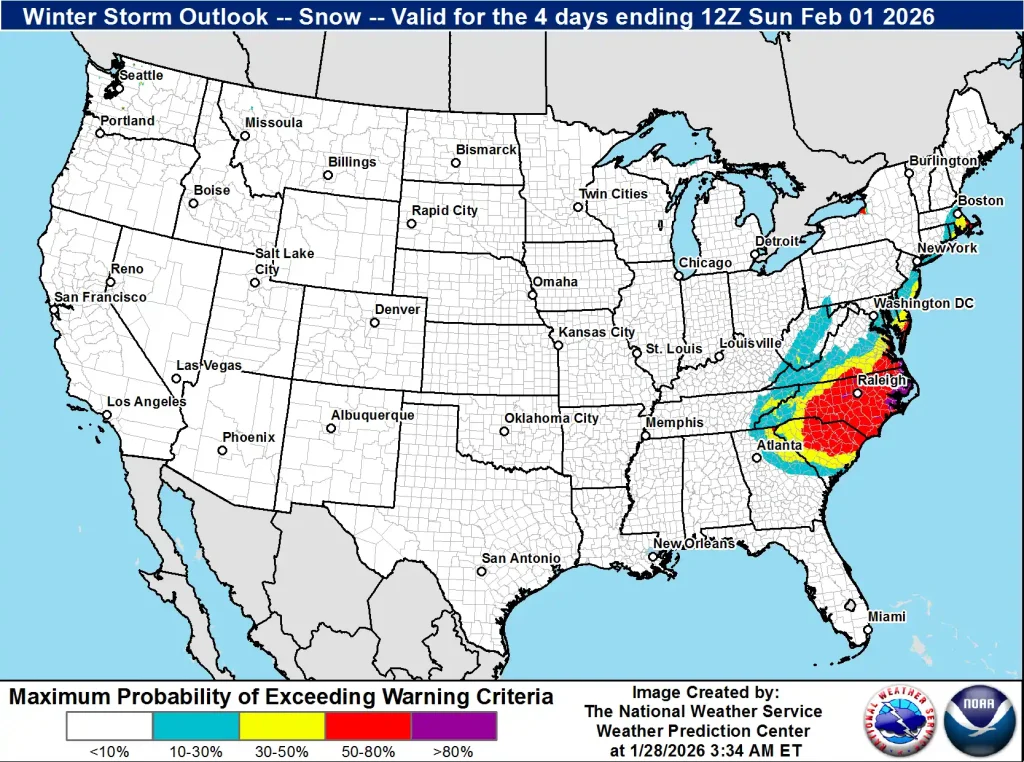
A surge of Arctic air will spread across the central and eastern United States from Friday, January 30, 2026, bringing the longest duration of cold in several decades to parts of the region. Forecast confidence has increased for a winter storm to develop along the East Coast over the weekend, with the highest likelihood of heavy snowfall across the Carolinas and southern Virginia, and gusty coastal winds extending into the Mid-Atlantic.

Snowfall on the Virginia Eastern Shore in February 2020. Credit: Miaya Dennis
A major Arctic air mass is forecast to descend southward through the Plains, Great Lakes, and into the Southeast and East beginning late Friday, January 30.
According to the National Weather Service (NWS), this surge could produce the longest sustained period of below-freezing temperatures in several decades across portions of the Midwest, Appalachians, and Southeast.
The Weather Prediction Center (WPC) reports growing confidence in a significant winter storm forming along the East Coast late Friday into Saturday. Probability maps issued early Wednesday, January 28 show a high chance, locally exceeding 60 percent, of at least moderate snowfall impacts across the Carolinas and southern Virginia. This includes hazardous travel conditions and possible localized power interruptions.
A Cold Weather Advisory has been issued for southeast West Virginia, far southwest Virginia, and northwest North Carolina for tonight.

Snow is forecast to begin Friday night and intensify on Saturday as the coastal low develops offshore. Areas along the Mid-Atlantic coast may experience gusty northeast winds coinciding with astronomical high tides.
NWS warns that these conditions could produce minor to moderate coastal flooding and dangerous surf, especially from the Outer Banks to the Delmarva Peninsula.
Uncertainty remains regarding the northern extent of the storm’s snowfall shield. Model differences persist for the system’s track beyond Virginia, leaving forecast details for the Mid-Atlantic, Northeast, and New England less certain at this stage.
“Significant disagreements still exist with the exact track of a developing coastal system during late Friday into Saturday,” meteorologists at the National Weather Service in Blacksburg, VA, noted on Wednesday, January 28.
A shortwave trough diving southward should deepen and become a closed low over the southern Appalachian Mountains. The natural baroclinic zone between the Arctic air from Canadian high pressure to the west and the warmer waters of the Gulf Stream to the east will help to rapidly deepen the surface low.
“At the moment, snow chances appear highest across the southern Blue Ridge and into the Piedmont. The snow should taper to upslope snow showers in southeast West Virginia by Sunday as a gusty northwest flow arrives behind the departing system.”
“It is still too early to predict any snowfall amounts due to the aforementioned disagreements, but the bottom line is that accumulating snow is becoming increasingly likely to occur for Friday and Saturday.”
Arctic air amidst a gusty northwest flow should arrive for the upcoming weekend behind the coastal system. Wind gusts may surpass advisory criteria along the southern Blue Ridge by Saturday night into Sunday, which will cause a sharp drop in temperatures and wind chill values and may even present an opportunity for blowing snow.
Based on the strong winds and low temperatures falling into the single digits and possibly below zero along the higher elevations by Sunday morning, wind chill values could reach −18 to −23°C (0 to −10°F) in the Piedmont and −23 to −29°C (−10 to −20°F) along and west of the Blue Ridge.
Even wind chill values down to −32°C (−25°F) may be possible for the higher peaks of western Greenbrier County and also for Mount Rogers. The frigid air mass should begin to moderate towards the middle of the upcoming week, according to NWS Blacksburg, VA.
I'm a dedicated researcher, journalist, and editor at The Watchers. With over 20 years of experience in the media industry, I specialize in hard science news, focusing on extreme weather, seismic and volcanic activity, space weather, and astronomy, including near-Earth objects and planetary defense strategies. You can reach me at teo /at/ watchers.news.
Commenting rules and guidelines
We value the thoughts and opinions of our readers and welcome healthy discussions on our website. In order to maintain a respectful and positive community, we ask that all commenters follow these rules.