
Remnant Alaska atmospheric river to merge with second plume, bringing prolonged AR conditions to western Washington
An atmospheric river that impacted Alaska on January 9, 2026, is forecast to propagate down the coast and merge with a second plume, delivering a 48–72-hour period of AR conditions over western Washington from January 10 to 12. Forecast guidance indicates 100–150 mm (4–6 inches) of rain over the Olympic Peninsula, 50–100 mm (2–4 inches) over the northern Washington Cascades, and 25–50 mm (1–2 inches) over the Cascade foothills, with freezing levels rising above 1 830 m (6 000 feet).
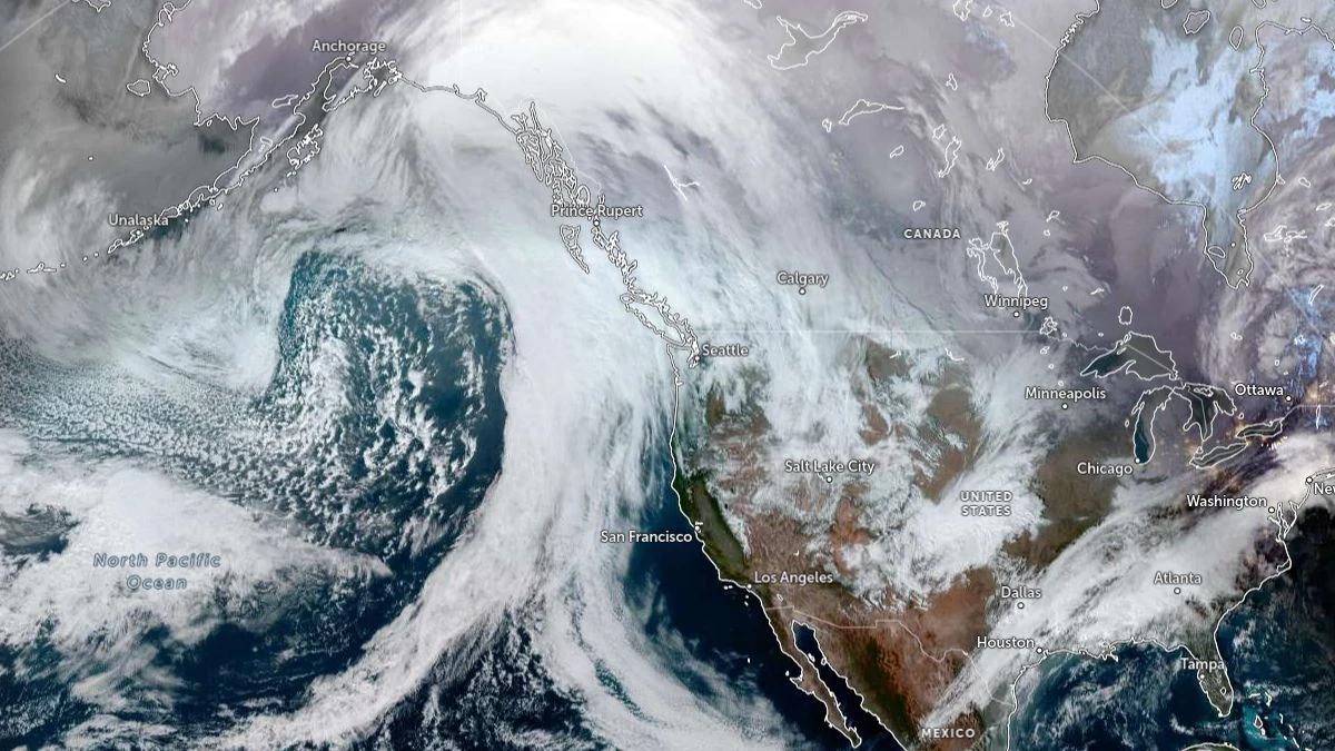
Satellite image of atmospheric river making landfall in Alaska and British Columbia acquired at 21:10 UTC on January 9, 2026. Credit: NOAA/GOES-West, Zoom Earth, The Watchers
CW3E’s latest Quick Look issued on January 9, 2026, reports increasing confidence in a prolonged period of atmospheric river (AR) conditions over western Washington.
Ensemble guidance from the GEFS-based landfall tool shows confidence in AR landfall increasing from about 60% to 99% in recent days. The moisture feeding this event originates from the AR that made landfall in southern Alaska and British Columbia on January 9, now forecast to move south and merge with a second AR on Sunday, January 11, keeping moisture transport into the region through Monday.
The same moisture plume produced heavy rain, strong winds, and rapid snowmelt across the Alaska Panhandle, prompting the National Weather Service (NWS) in Juneau to issue Flood Watches. Multiple waves of precipitation, low visibility, and wind gusts were observed as the warm front advanced across the Panhandle, marking the start of the broader sequence now extending into the Pacific Northwest.
For western Washington, NWS Seattle forecasts moderate to heavy rain from Saturday night through Monday night, January 10 to 12.
Snow levels are expected to rise to around 1 800 m (6 000 feet) on Sunday and reach 2 300–2 440 m (7 500–8 000 feet) by Monday, creating rain-on-snow conditions across Cascade watersheds. Southerly winds are projected to gust 50–65 km/h (30–40 mph) along the coast and north of Everett.
The Skokomish River in Mason County is forecast to exceed flood stage, with other rivers across western Washington expected to approach action stage depending on rainfall intensity and duration.

The Weather Prediction Center (WPC) forecasts approximately 100–150 mm (4–6 inches) of precipitation over the Olympic Peninsula, 50–100 mm (2–4 inches) over the northern Washington Cascades, and 25–50 mm (1–2 inches) over the Cascade foothills during the 72-hour period ending around 16:00 PST, January 13.
The ECMWF ensemble (EPS) mean is about 38 mm (1.5 inches) higher than the GEFS over the Hoh–Quillayute watershed, with roughly 70% of EPS members and 20% of GEFS members exceeding 125 mm (5 inches).
Freezing levels are forecast to rise above 1 830 m (6 000 feet) as the second AR moves onshore, ensuring most precipitation falls as rain. The NWS Northwest River Forecast Center expects six gauges to reach action stage by Tuesday, consistent with ongoing rain-on-snow melt in the Cascades.
CW3E notes that in coordination with the U.S. Air Force, Atmospheric River Reconnaissance (AR Recon) aircraft will be deployed to sample the moisture plumes and adjacent synoptic structures to improve forecast accuracy.
The synoptic setup, a ridge along the U.S. West Coast and a trough over the Northeast Pacific, will steer moisture into the region, sustaining high integrated vapor transport through Monday. Both CW3E and NWS Seattle anticipate a drying trend beginning mid-week as the ridge strengthens, allowing rivers to crest and gradually recede.
References:
1 AR Forecast to Bring Precipitation to the Washington – CW3E – January 9, 2026
I'm a dedicated researcher, journalist, and editor at The Watchers. With over 20 years of experience in the media industry, I specialize in hard science news, focusing on extreme weather, seismic and volcanic activity, space weather, and astronomy, including near-Earth objects and planetary defense strategies. You can reach me at teo /at/ watchers.news.
Commenting rules and guidelines
We value the thoughts and opinions of our readers and welcome healthy discussions on our website. In order to maintain a respectful and positive community, we ask that all commenters follow these rules.