
Japan braces for another heavy snow event following early-January traffic paralysis
Japan Meteorological Agency (JMA) forecasts heavy snowfall around January 11–12, 2026, as a strong cold surge moves over Honshu, with warning-level accumulations expected along the Sea of Japan side including Hokuriku and Tohoku. Regional observatories report the potential for five-day snowfall totals exceeding 160 percent of seasonal averages, a rare magnitude for this time of year. This follows the early-January snowstorm that immobilized about 3 000 vehicles over a 23 km (14 miles) stretch of the Sanyō Expressway in western Japan.
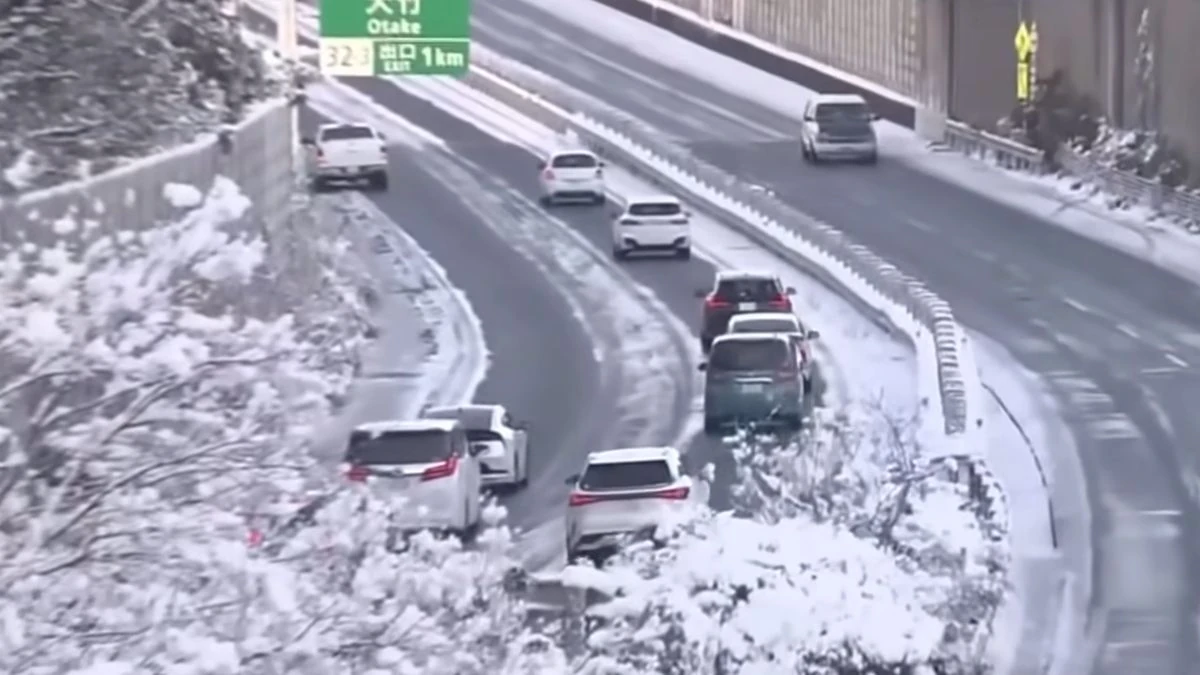
Traffic on the Sanyō Expressway came to a standstill between Hiroshima and Yamaguchi Prefectures on January 2–3, 2026, as heavy snow caused a 23 km (14 mile) jam involving roughly 3 000 vehicles. Credit: ANNnewsCH
A pronounced winter pressure pattern is forecast to intensify from Sunday, January 11, through Monday, January 12, as Arctic air moves southward across Japan.
The JMA’s early attention information indicates elevated probabilities for heavy, warning-level snowfall on the Sea of Japan side, particularly Hokuriku, northern Nagano and Gunma, and the mountain areas of Gifu.
At 14:30 LT on January 5, the Sendai Regional Meteorological Observatory announced that a winter-type pressure pattern will strengthen around January 12 and may produce significant snowfall across Tohoku.
Under JMA criteria, heavy snow corresponds to a five-day accumulation reaching 164 percent or more of the climatological mean. In Tohoku, average five-day totals for this period are 30 to 35 cm (12–14 inches) in Goshogawara and Hirosaki, 32 cm (13 inches) in Aomori, 75 cm (30 inches) in Sukayu, and 15 to 40 cm (6–16 inches) across much of Akita and Yamagata Prefectures, implying potential event totals of 50 to 120 cm (20–47 inches) in affected areas.
JMA issues early weather information when the probability exceeds 30% for anomalies that occur roughly once in ten years for that calendar window. The current issuance, therefore, represents a climatologically rare setup for early January.
Forecast models indicate the cold surge will persist through about January 14, bringing further snowfall on the Sea of Japan side and possible low-elevation accumulation in parts of western Honshu.
Before the main surge, intermittent snow and gusty winds are expected on January 8 and 10. Transport operators have been advised to prepare for temporary closures or restrictions on expressways, while agricultural sectors are urged to secure greenhouses and monitor snow load.
This renewed warning follows the early-January snowstorm that caused large-scale disruption across western Japan.
Between the night of January 2 and January 3, wet heavy snow blanketed sections of the Sanyō Expressway, trapping about 3 000 vehicles over roughly 23 km (14 miles) between Hiroshima and Yamaguchi prefectures. The jam persisted for 10–15 hours during the New Year travel peak, with one driver hospitalized for dizziness and nausea. No fatalities were reported.
The congestion was triggered by vehicles losing traction on gradients and blocking lanes, combined with rapid snow accumulation.
West Nippon Expressway Company (NEXCO West) and Hiroshima Prefectural Police conducted continuous snow-clearing and towing operations through the night; by midday January 3, traffic flow was gradually restored as road closures were lifted.
JMA issued heavy-snow advisories for the Sanyō region before the event, and post-storm analyses identified moist air inflow and near-freezing surface layers as key factors in rapid accumulation.
With another cold surge expected, authorities urge early logistical planning and close monitoring of updated JMA bulletins, noting that warning-level snowfall could again impact transport and power infrastructure along the Sea of Japan side next week.
I'm a dedicated researcher, journalist, and editor at The Watchers. With over 20 years of experience in the media industry, I specialize in hard science news, focusing on extreme weather, seismic and volcanic activity, space weather, and astronomy, including near-Earth objects and planetary defense strategies. You can reach me at teo /at/ watchers.news.
Commenting rules and guidelines
We value the thoughts and opinions of our readers and welcome healthy discussions on our website. In order to maintain a respectful and positive community, we ask that all commenters follow these rules.