
Freeze warnings extend from Florida to Maryland as early-season cold blast grips the East
The National Weather Service has issued widespread Freeze Warnings from northern Florida to Maryland as sub-freezing temperatures spread across the eastern United States on November 11–12, 2025. Overnight lows between -6 and -1 °C (22 and 30 °F) are forecast across much of the region, marking the coldest air of the season so far.

Image credit: Harris County
Millions are under freeze warnings from inland northern Florida through Georgia, the Carolinas, Virginia, and into southern Maryland as of November 11.
The alerts cover multiple National Weather Service (NWS) forecast offices, including Jacksonville, Raleigh, and Baltimore/Washington, with sub-freezing temperatures expected through early Wednesday morning in several inland and coastal areas.
In North Carolina, the NWS Raleigh office reported forecast lows of -6 to -1°C (22–30°F), while the Baltimore/Washington office anticipates -3 to -1°C (27–30°F) in parts of Maryland and northern Virginia. Inland portions of Florida and southern Georgia are also under warnings, with local lows near freezing.
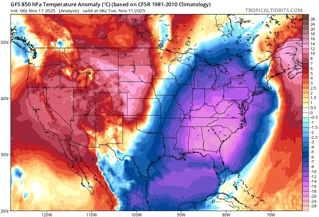
The event is linked to an early-season outbreak of Arctic air that moved southward from central Canada behind a strong cold front.
A high-pressure ridge centered over the southeastern states is causing radiational cooling, allowing temperatures to fall rapidly under clear skies. This marks one of the first widespread freezes of the season across the region.
NWS advisories caution that frost and freeze conditions could damage or destroy crops and sensitive plants, particularly across agricultural areas of northern Florida and southern Georgia.
Residents are urged to protect exposed pipes and bring pets indoors. Several municipalities have opened temporary cold-weather shelters to mitigate risks for unhoused populations.
Forecast discussions indicate that the cold air mass will linger into midweek before a gradual warming trend begins as the high pressure shifts eastward.
Counties under freeze warnings
| State | Counties / Parishes | Expiration Time |
|---|---|---|
| Florida (FL) | North Walton, Central Walton, Holmes, Washington, Inland Bay, Inland Gulf, Inland Franklin, South Walton, Coastal Bay, Coastal Gulf, Coastal Franklin, Coastal Jefferson, Coastal Wakulla, Coastal Taylor, Coastal Dixie, Coastal Citrus, Coastal Levy, Inland Citrus, Inland Hernando, Inland Levy (also November 12), Suwannee, Baker, Nassau, Union, Bradford, Gilchrist, Hamilton, Clay, Alachua, Putnam, Marion, Columbia, Duval, St. Johns, Flagler | 08:00 EST / 07:00 CST on Tuesday, November 11, 2025; extended to 08:00 on Wednesday, November 12, 2025, for parts of northern Florida |
| Georgia (GA) | Lincoln, McDuffie, Columbia, Richmond, Burke; portions of northeast and southwest Georgia (Stephens, Franklin, Hart, Elbert, Early, Miller, Baker, etc.); all of north and central Georgia including Atlanta metro and surrounding counties | 09:00 – 10:00 EST on Tuesday, November 11, 2025 |
| South Carolina (SC) | Chesterfield, McCormick, Newberry, Fairfield, Kershaw, Edgefield, Saluda, Lexington, Richland, Lee, Aiken, Sumter, Barnwell, Calhoun, Clarendon, Bamberg, Northern and Southern Lancaster, Northwestern, Central and Southeastern Orangeburg, Inland Berkeley | 09:00 EST on Tuesday, November 11, 2025 |
| North Carolina (NC) | Person, Granville, Vance, Warren, Halifax, Forsyth, Guilford, Alamance, Orange, Durham, Franklin, Nash, Edgecombe, Davidson, Randolph, Chatham, Wake, Johnston, Wilson, Stanly, Montgomery, Moore, Lee, Harnett, Wayne, Anson, Richmond, Scotland, Hoke, Cumberland, Sampson, Northampton, Hertford, Gates, Pasquotank, Camden, Western and Eastern Currituck, Bertie, Chowan, Perquimans | 09:00 EST on Tuesday, November 11, 2025 |
| Virginia (VA) | Mecklenburg, Brunswick, Dinwiddie, Prince George, Charles City, New Kent, Hanover, Chesterfield, Henrico, King William, King and Queen, Essex, York, James City, Greensville, Sussex, Surry, Southampton, Isle of Wight, Norfolk/Portsmouth, Suffolk, Chesapeake, Virginia Beach, Gloucester, Middlesex, Mathews, Westmoreland, Richmond, Northumberland, Lancaster, King George, Newport News, Hampton/Poquoson, Accomack, Northampton | 09:00 EST on Tuesday, November 11, 2025 |
| Maryland (MD) | Calvert, St. Mary’s | 09:00 EST on Tuesday, November 11, 2025 |
| Alabama (AL) | Choctaw, Washington, Clarke, Wilcox, Monroe, Conecuh, Butler, Crenshaw, Escambia, Covington, Mobile, Baldwin, Coffee, Geneva, Dale, Henry, Houston | 08:00 CST on Tuesday, November 11, 2025; extended to 08:00 on Wednesday, November 12, 2025, for Dale, Henry, and Houston |
| Mississippi (MS) | Wayne, Perry, Greene, Stone, George; portions of southeast and central Mississippi | 08:00 CST on Tuesday, November 11, 2025 |
| Louisiana (LA) | Vernon, Rapides, Avoyelles, Beauregard, Allen, Evangeline, St. Landry, Lafayette, St. Martin, St. Mary, Vermilion, Acadia, Iberia, Calcasieu, Jefferson Davis, Pointe Coupee, West and East Feliciana, St. Helena, Iberville, West and East Baton Rouge, Assumption, St. James, St. John the Baptist, Lafourche, St. Charles, Tangipahoa, Livingston, Ascension, Jefferson, Plaquemines | 09:00 CST on Tuesday, November 11, 2025 |
| Texas (TX) | Tyler, Hardin, Jasper, Newton, Orange | 09:00 CST on Tuesday, November 11, 2025 |
| Arizona (AZ) | Graham, Cochise | 09:00 MST on Tuesday, November 11, 2025 |
| New York (NY) | Manhattan, Bronx, Staten Island, Brooklyn, Queens (south and north), Southern Westchester, Northwest and Northeast Suffolk, Southwest and Southeast Suffolk, Northern and Southern Nassau | 09:00 EST on Tuesday, November 11, 2025 |
| Connecticut (CT) | Southern Fairfield, Southern New Haven, Southern Middlesex, Southern New London | 09:00 EST on Tuesday, November 11, 2025 |
| New Jersey (NJ) | Hudson, Eastern Bergen, Eastern Essex, Eastern Union | 09:00 EST on Tuesday, November 11, 2025 |

I am an Assistant Editor and Severe Weather & Science Journalist at The Watchers, specializing in real-time severe weather coverage, geophysical event reporting, and research-driven scientific analysis. You can reach me at rishav(at)watchers(.)news.
Commenting rules and guidelines
We value the thoughts and opinions of our readers and welcome healthy discussions on our website. In order to maintain a respectful and positive community, we ask that all commenters follow these rules.