
Major to extreme impacts expected across the central Sierra Nevada as Pacific storm moves into California
A Pacific storm will move into California from the northwest between October 13 and 15, 2025, bringing widespread valley rain and heavy snow to the Sierra Nevada. Snowfall totals along the Sierra crest may reach 30–90 cm (12–36 inches), with hazardous driving conditions expected across Interstate 80 and other major passes. The National Weather Service warns that chain controls and travel delays are likely during the peak of the event.
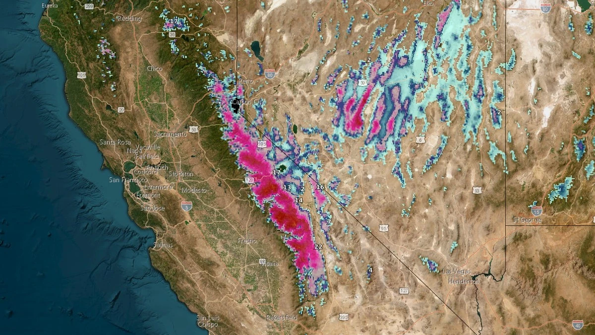
Winter Storm Severity Index indicates major to extreme impacts across the central Sierra Nevada through October 16, 2025. Credit: NWS
A Pacific storm system is moving into California from the northwest, bringing widespread valley rain and heavy mountain snow between Monday, October 13 and Wednesday, October 15.
The National Weather Service (NWS) forecasts precipitation developing across Northern California early Monday and spreading southward into Central and Southern California by Tuesday as upper-level energy drops into the state.
Rain is expected to increase in coverage and intensity through Monday evening, with the heaviest precipitation occurring along the coast and western slopes of the Sierra Nevada.
Snow levels will fall to around 2 100 m (6 900 feet) as colder air arrives, producing heavy, wet snow across higher elevations. Along the Sierra crest, snowfall totals of 30 to 90 cm (12 to 36 inches) are possible, with lower slopes likely receiving lighter accumulations. The heaviest snow is forecast between Yosemite and Lake Tahoe, where travel conditions will deteriorate rapidly as snow intensifies.
The NWS Weather Prediction Center (WPC) notes that the Winter Storm Severity Index (WSSI) indicates major to extreme impacts across the central Sierra Nevada, where travel could become dangerous or impossible at times. Interstate 80, Highway 50, and other trans-Sierra routes may experience long delays, chain controls, and temporary closures.
The wet, heavy nature of the snow could also weigh down trees and power lines, increasing the risk of localized outages.
The major impact zone, shown in red on the map below, covers much of the high Sierra between roughly Yosemite National Park and the Lake Tahoe region. Within this area, the WSSI describes conditions as producing dangerous or impossible travel with widespread road closures and disruptions to infrastructure, likely.
Prolonged snow and reduced visibility will make movement through mountain passes hazardous, and travel should be avoided when possible. Embedded within this zone, smaller pockets of extreme impacts, shown in purple, are forecast near the highest elevations along the Sierra crest. These areas are expected to experience extremely dangerous or impossible travel and extensive, widespread closures and disruptions to infrastructure.
Life-saving actions may be needed in these regions if travelers become stranded or emergency access is limited.

In addition to snow, the system will draw substantial Pacific moisture into Southern California and the Southwest on Tuesday and Wednesday.
The WPC has issued a Slight Risk, level 2 of 4, of excessive rainfall for parts of these regions. Periods of heavy rain could lead to localized flash flooding, particularly in urban areas, small streams, and in or near recent burn scars where debris flows may occur.
By late Wednesday, the storm is forecast to weaken and move east into the Great Basin, bringing a gradual decrease in precipitation across California.
I'm a dedicated researcher, journalist, and editor at The Watchers. With over 20 years of experience in the media industry, I specialize in hard science news, focusing on extreme weather, seismic and volcanic activity, space weather, and astronomy, including near-Earth objects and planetary defense strategies. You can reach me at teo /at/ watchers.news.
Commenting rules and guidelines
We value the thoughts and opinions of our readers and welcome healthy discussions on our website. In order to maintain a respectful and positive community, we ask that all commenters follow these rules.