
Flood Watches in effect as post-tropical Mario drives moisture into the U.S. Southwest
Moisture from post-tropical Mario is forecast to spread into southern California on September 18, 2025, bringing thunderstorms and rainfall totals of 25–75 mm (1–3 inches) through Friday. Rainfall rates may exceed 25 mm/h (1 inch/h), prompting Flood Watches and Flash Flood Watches across much of the region. Arizona and New Mexico are also expected to see widespread showers and thunderstorms with localized flooding into September 19.
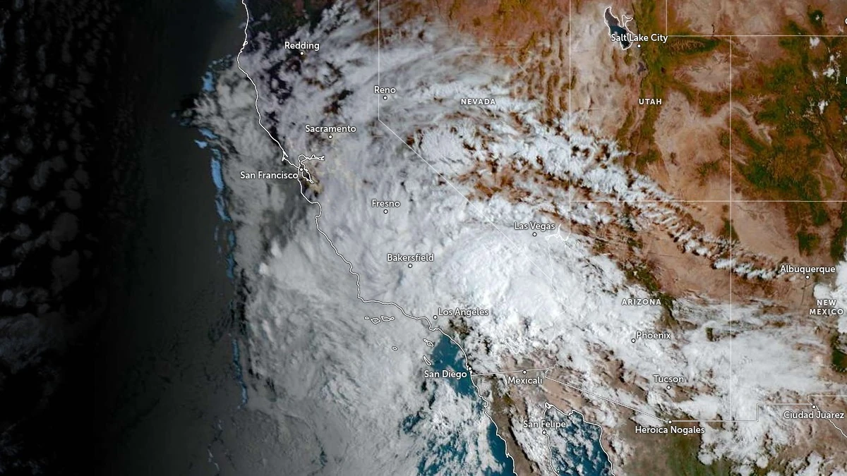
Satellite image of southwest U.S. at 14:50 UTC on September 18, 2025. Credit: NOAA/GOES-East, RAMMB/CIRA, The Watchers
Moisture associated with remnants of Tropical Strom Mario is expected to enhance rainfall across southern California from Thursday into Friday.
According to the National Weather Service (NWS), precipitable water values near 50 mm (2 inches) will move inland, reaching around 200–250% of normal for the region. Rainfall rates greater than 25 mm/h (1 inch/h) are expected in some areas, which could trigger flash flooding in sensitive terrain, burn scar areas, and urbanized flood-prone zones.
Rainfall totals of 25–75 mm (1–3 inches) are expected, with locally higher amounts possible under thunderstorms. Flood Watches are in effect across most southern California counties.
The greatest impacts are anticipated from Thursday afternoon into Friday morning, when the deepest plume of tropical moisture aligns with daytime instability. The NWS has cautioned that debris flows could occur near recent burn scars.
In addition to heavy rain, thunderstorms are expected to produce frequent lightning and localized strong winds.

Arizona is also forecast to receive widespread showers and thunderstorms, with the NWS Phoenix office issuing Flood Watches for southwestern parts of the state. Some areas there could record more than 25 mm (1 inch) of rainfall. As a result, localized flooding, outflow-driven gusts, and blowing dust are possible.
Further east, the NWS Albuquerque office has issued Flood Watches for parts of New Mexico, including the Sacramento Mountains and southwestern zones. Thunderstorms there may bring 12–25 mm (0.5–1 inch) of rainfall, with the potential for rapid rises in arroyos and flash flooding in burn scar terrain.
Although Mario has lost its tropical cyclone structure, its remnant circulation is forecast to continue channeling tropical moisture into the Southwest. The NWS advises residents in vulnerable areas to closely monitor local forecasts and prepare for flash flooding through September 19.
References:
1 Short Range Public Discussion – NWS/WPC – September 18, 2025
2 Area Forecast Discussion – NWS Los Angeles/Oxnard – September 18, 2025
I'm a dedicated researcher, journalist, and editor at The Watchers. With over 20 years of experience in the media industry, I specialize in hard science news, focusing on extreme weather, seismic and volcanic activity, space weather, and astronomy, including near-Earth objects and planetary defense strategies. You can reach me at teo /at/ watchers.news.
Commenting rules and guidelines
We value the thoughts and opinions of our readers and welcome healthy discussions on our website. In order to maintain a respectful and positive community, we ask that all commenters follow these rules.