
Giant hail and tornadoes hit Afton area, Texas as storms sweep through southern U.S.
Giant hail measuring up to 15 cm (6 inches) struck Afton, Texas, on Sunday, May 25, 2025, as storms swept across the southern U.S. during Memorial Day weekend. The storms were accompanied by multiple tornadoes, with at least five reported in Texas, including one near Afton.
A quasi-stationary storm system brought large hail to the Southeast and Mid-Atlantic on Sunday, May 25, with reports of hailstones exceeding 10 cm (4 inches) in diameter in parts of Texas.
The Storm Prediction Center received three of the largest hail reports from Afton, with measurements of 15 cm (6 inches), 13 cm (5 inches), and 11.5 cm (4.5 inches). Additional reports on social media indicated hailstones in the Afton area measuring between 14 and 15 cm (5.5 to 6 inches).
At least six tornadoes were reported on Sunday, including five in Texas and one in New Mexico. One tornado occurred near Afton.
A green-hued supercell was observed near Guthrie, producing large hail up to 13 cm (5 inches) in diameter and giving the sky a greenish-blue hue.
GREENAGE supercell with #tornado warning and bright blue clear slot dropping 5 inch diameter gorilla hail NW of Guthrie, Texas! pic.twitter.com/38WZc140BV
— Reed Timmer, PhD (@ReedTimmerUSA) May 25, 2025
The storms were part of a slow-moving system extending from the Southeast to the Central Rockies, bringing severe weather to parts of the southern United States, including Texas, Missouri, and Oklahoma, on May 25.
Storm damage was reported across Oklahoma on Saturday, May 24, as storms downed trees and power lines, damaged buildings, and left nearly 60 000 people without power.
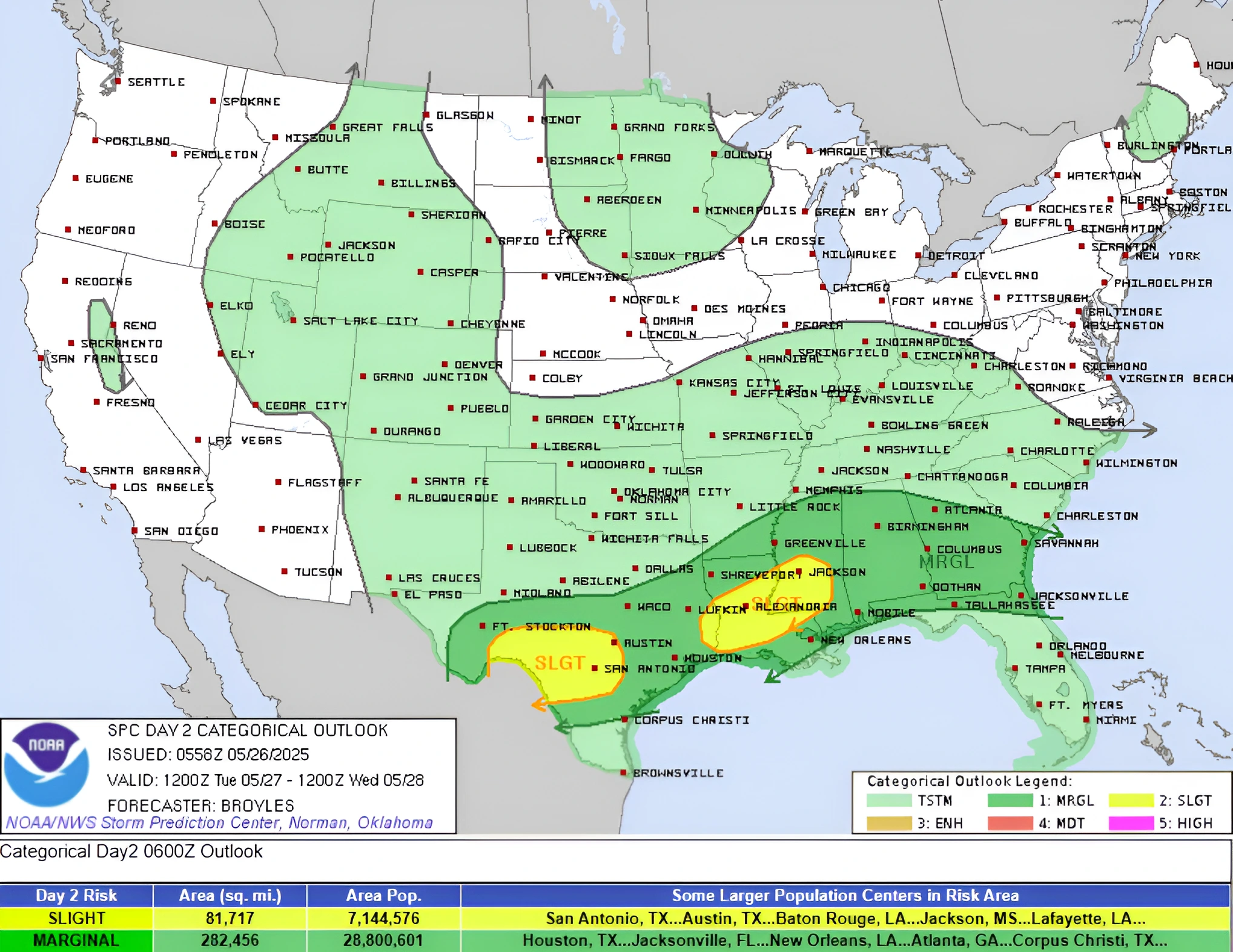
The quasi-stationary front will see a wave of low pressure move into the Ohio Valley by Wednesday, May 28. Moisture flowing northward from the Gulf of America will overrun the boundary, producing showers and thunderstorms with heavy rainfall over parts of the Southern Plains and Lower Mississippi and Tennessee Valleys.
The Weather Prediction Center (WPC) has issued a Slight Risk (level 2/4) of excessive rainfall over parts of these regions through Tuesday morning, May 27. The associated heavy rainfall may result in mainly localized flash flooding, with urban areas, roads, small streams, and low-lying areas being the most vulnerable.
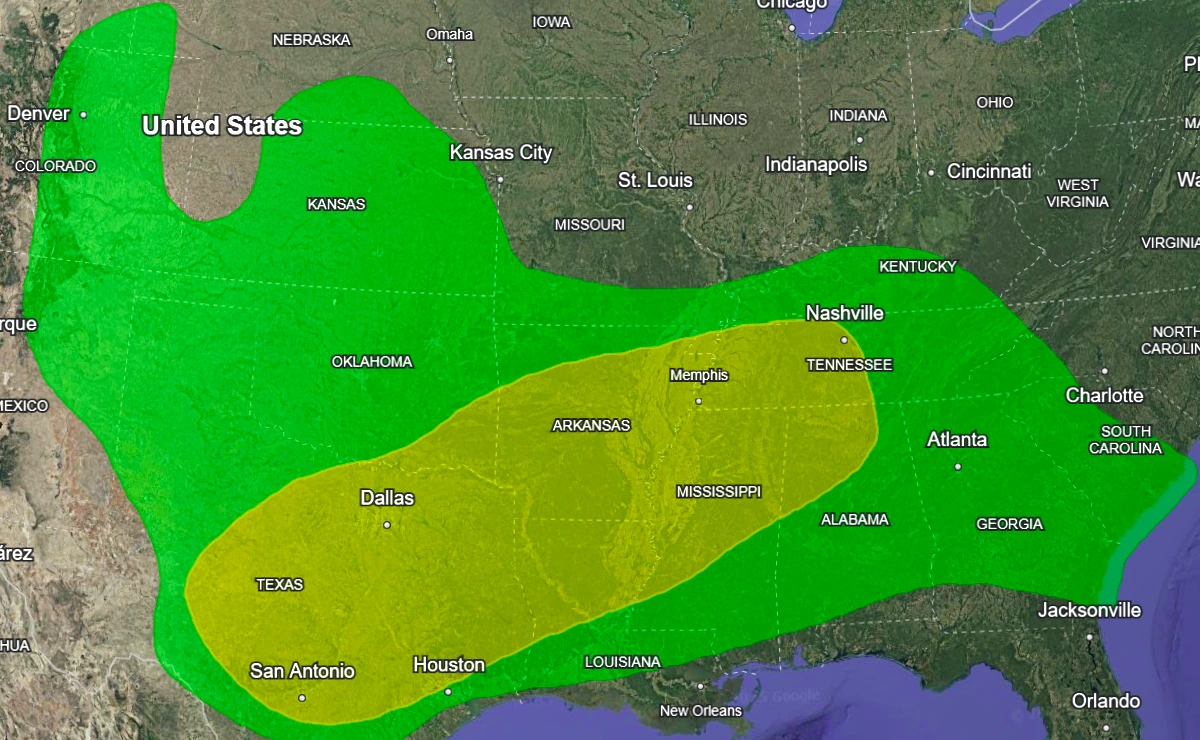
Severe thunderstorms are expected to develop over parts of the Southern Plains and Lower Mississippi Valley. The Storm Prediction Center (SPC) has issued a Slight Risk (level 2/5) of severe thunderstorms over parts of the Southern Plains and Lower Mississippi Valley through Tuesday morning.
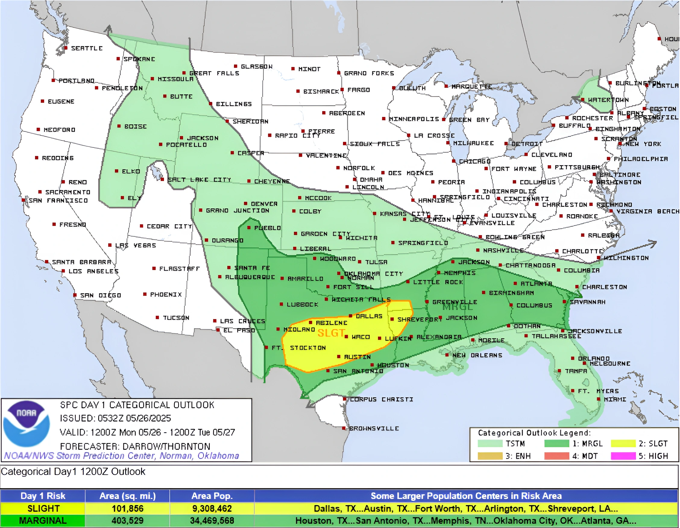
Associated hazards include frequent lightning, severe thunderstorm wind gusts, hail, and a few tornadoes. An increased risk of hailstones measuring 5 cm (2 inches) or greater exists over parts of the Southern Plains.
Additionally, showers and thunderstorms will develop over parts of the Central Plains and extend into the Northern Rockies on Monday, May 26.
On Tuesday, the stationary front will begin moving southeastward over the Southern Plains and into the Lower Mississippi Valley, producing severe thunderstorms.
The associated heavy rainfall may result in mainly localized flash flooding, particularly in urban areas, along roads, small streams, and low-lying regions.
As the wave of low pressure enters the Ohio Valley, showers and thunderstorms will bring heavy rain to parts of the Ohio Valley and Central Appalachians.
The WPC has issued a Slight Risk (level 2/4) of excessive rainfall over these regions from Tuesday through Wednesday morning. The heavy rainfall may lead to mainly localized flash flooding, especially in urban areas, roads, small streams, and low-lying areas.
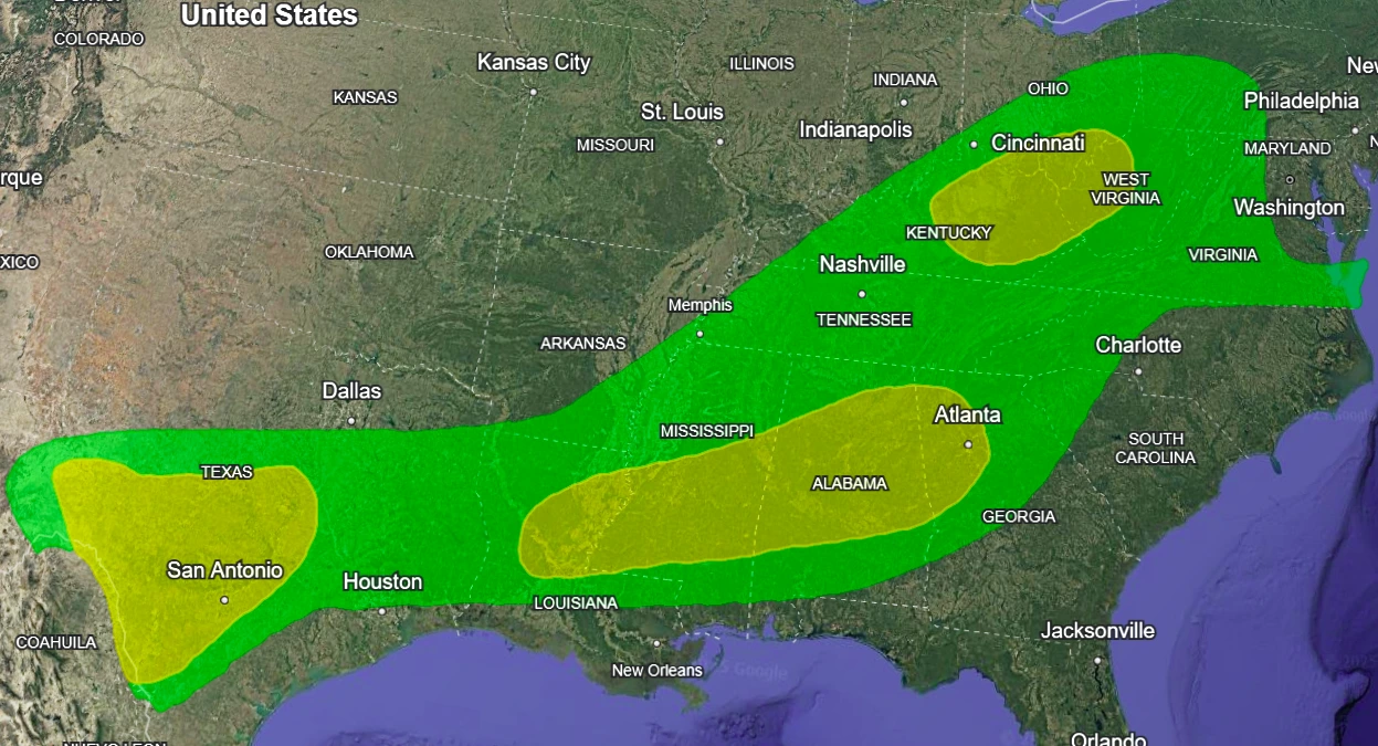
The SPC has issued a Slight Risk (level 2/5) of severe thunderstorms for two areas: the Southern Plains and the Lower Mississippi Valley, from Tuesday through Wednesday morning.
Hazards include frequent lightning, severe thunderstorm wind gusts, hail, and a few tornadoes. There remains an increased risk of hailstones measuring 5.1 cm (2 inches) or greater over parts of the Southern Plains.
The risk of excessive rainfall will also extend along the front from the Southern Plains to the Southeast. Accordingly, the WPC has issued a Slight Risk (level 2/4) of excessive rainfall for the Southern Plains and the Lower Mississippi Valley into the Southeast from Tuesday through Wednesday morning.
In addition, the wave of low pressure will bring rainfall to parts of the Upper Midwest, Lower Great Lakes, and Mid-Atlantic from Tuesday into Wednesday. Showers and thunderstorms are also expected to develop over the Southeast.
Read more:
Featured image: Tornado on the ground moving towards Stamford, Texas on May 25, 2025. Credit: Ranchin Boone

I am an Assistant Editor and Severe Weather & Science Journalist at The Watchers, specializing in real-time severe weather coverage, geophysical event reporting, and research-driven scientific analysis. You can reach me at rishav(at)watchers(.)news.
Commenting rules and guidelines
We value the thoughts and opinions of our readers and welcome healthy discussions on our website. In order to maintain a respectful and positive community, we ask that all commenters follow these rules.