
Widespread damage in Oklahoma as storms continue through Memorial Day weekend
Severe storms swept across Oklahoma on Saturday, May 24, 2025, causing widespread damage and producing a likely tornado near Asher. The system is forecast to continue affecting Oklahoma and much of the southern United States, bringing flash floods and thunderstorms through the Memorial Day weekend.

Storm Damage in Skiatook, Oklahoma on Saturday, May 24, 2025. Credit: Skiatook Electric
Severe storms moved across Oklahoma on Saturday, May 24, causing widespread damage due to strong winds, large hail, and at least one possible tornado.
Quarter-sized hail was reported in the Oklahoma City area early Saturday morning, with some hailstones reaching golf-ball-size amid wind gusts of up to 124 km/h (77 mph) near Ada.
Social media reports indicated a possible tornado near Asher on Saturday. A Tornado Warning was issued around 03:30 local time for Asher, Tribbey, and Wanette, placing approximately 2 500 people and six schools under alert.
A storm chaser from KOCO 5 News reported observing multiple power flashes and atmospheric rotation indicative of a tornado. However, officials have not yet confirmed the tornado or completed a damage survey.
Multiple other towns across northern and eastern Oklahoma reported gusts of 89– 113 km/h (55–70 mph), leaving nearly 60 000 customers without power across the state, according to FindEnergy.com.
More than half the outages were in the Tulsa area, where gusts hit 89 km/h (55 mph). Power outages dropped significantly by Sunday morning, with just over 16 000 outages reported as crews worked overnight to restore power lines.
Crews have restored power to more than 33,000 customers, and they'll keep working around the clock to get the lights back on. We appreciate your patience as they work safely and as quickly as possible.
— Public Service Co. (@PSOklahoma) May 25, 2025
https://t.co/lCLqjyrmVv
Storm Update #2: https://t.co/R1JENaQBX7 pic.twitter.com/k5oAD8LCY3
Power outages were reported in the city of Skiatook as well, where strong winds caused damage to the City Hall. Although power outage issues across the city were being resolved, the Skiatook Electric company couldn’t confirm whether power was restored for all customers or not.
“With our meter system down because of the damage to City Hall, we are unable to confirm that all power is restored. Based on the current call sheet, we believe we have everyone that can be connected to the system, back on,” said Skiatook Electric.
Heavy rainfall associated with the storm led to multiple instances of flash flooding. Social media images showed water damage to wooden homes in parts of the state, including the town of Inola.
The severe weather is the result of a quasi-stationary front extending from the Southeast to the Southern Plains and Central Rockies, which is expected to persist through Tuesday, May 27.
Moisture moving northward from the Gulf of America will overrun the boundary, producing showers and thunderstorms with heavy rainfall over parts of the Southern Plains and the Lower Mississippi and Tennessee Valleys through Sunday.
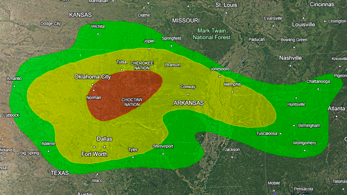
The Weather Prediction Center (WPC) has issued a Moderate Risk (level 3/4) of excessive rainfall over these areas through Monday morning. Numerous flash flooding events are possible, and stream flooding may occur, potentially impacting larger rivers.
The Storm Prediction Center (SPC) has issued an Enhanced Risk (level 3/5) of severe thunderstorms over the Southern Plains through Sunday morning.
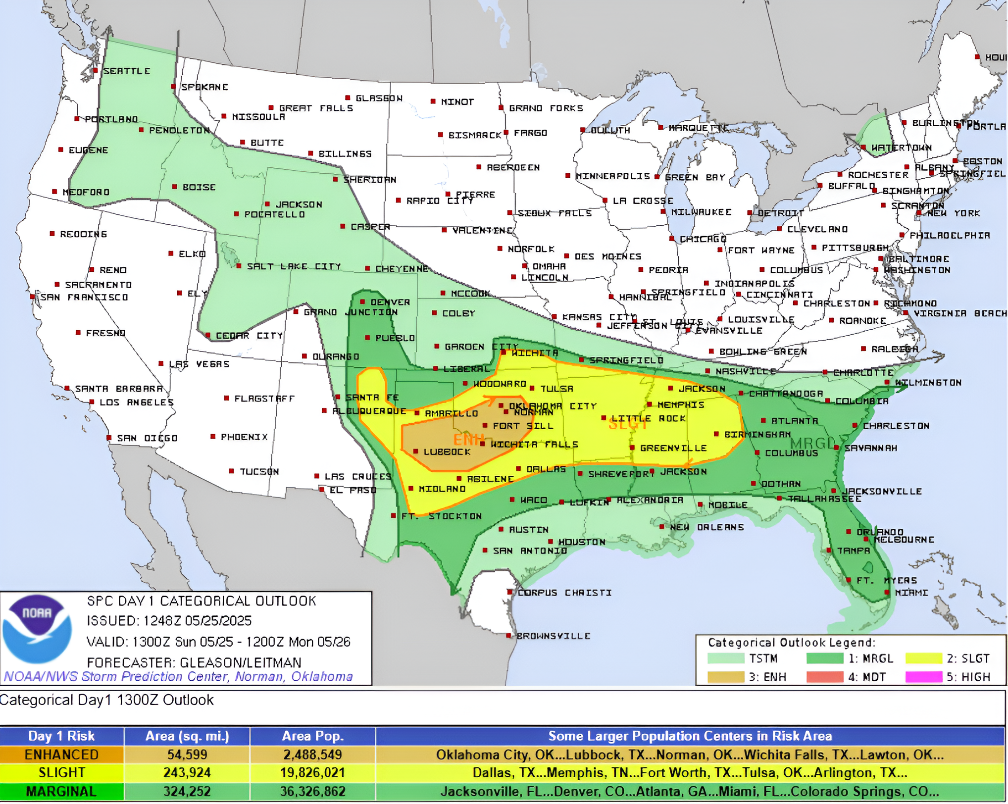
Associated hazards include frequent lightning, strong wind gusts from severe thunderstorms, hail, and isolated tornadoes. There is also an elevated risk of wind gusts reaching 120 km/h (75 mph) or higher and hail with diameters of 5 cm (2 inches) or more in the region.
Showers and thunderstorms are expected to develop over parts of the Southeast and the southern Mid-Atlantic region on Sunday.
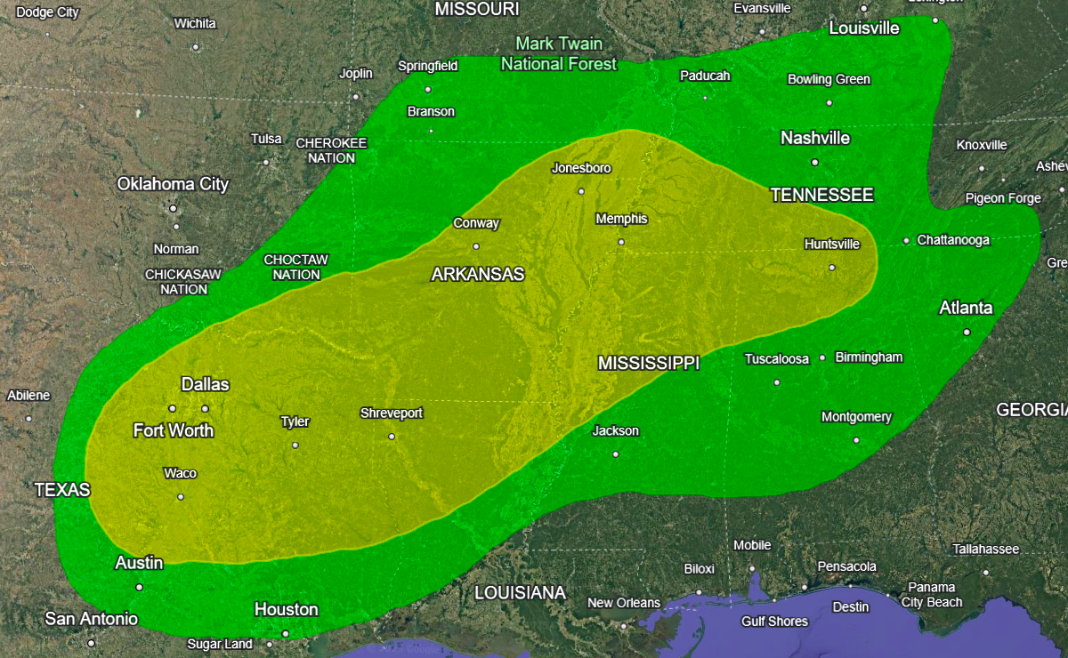
On Monday, the risk of showers and thunderstorms with heavy rainfall continues across parts of the Southern Plains, the Lower Mississippi Valley, and the Tennessee Valley.
The WPC has issued a Slight Risk (level 2/4) of excessive rainfall for these areas from Monday through Tuesday morning. The associated heavy rain will create mainly localized areas of flash flooding, with urban areas, roads, small streams, and low-lying areas the most vulnerable.
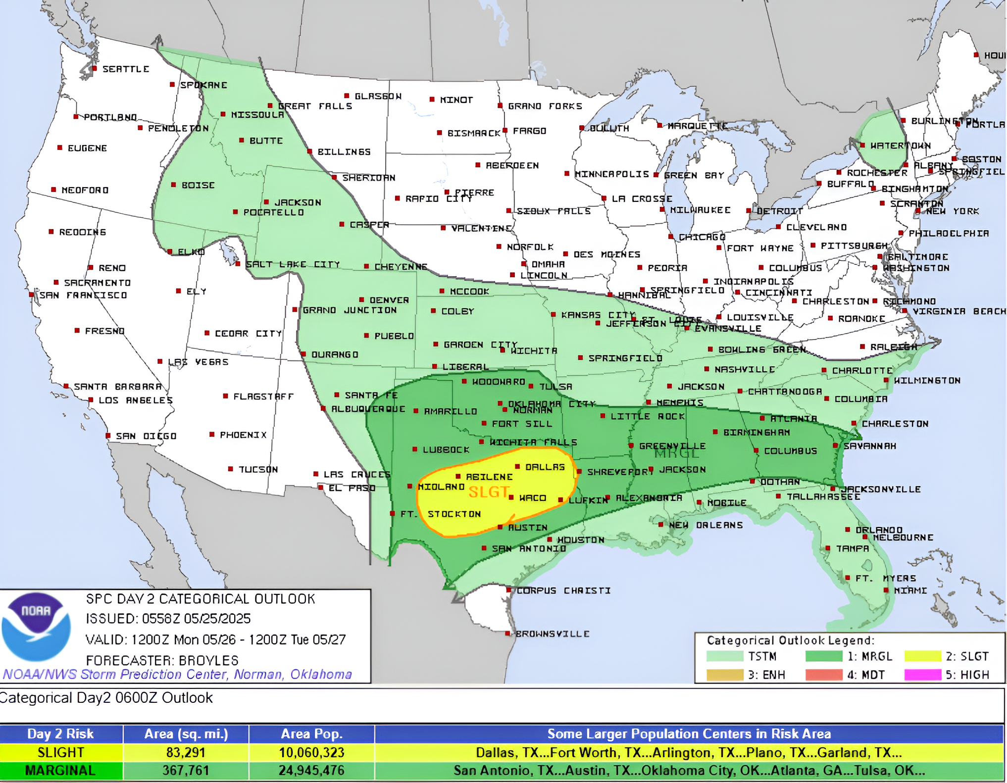
Severe thunderstorms are also expected to continue over parts of the Southern Plains from Monday through Tuesday morning.
The SPC has issued a Slight Risk (level 2/5) for severe thunderstorms. Hazards include frequent lightning, strong wind gusts, hail, and isolated tornadoes. There is also an increased risk of hail measuring 5 cm (2 inches) or more in diameter in parts of the region.

I am an Assistant Editor and Severe Weather & Science Journalist at The Watchers, specializing in real-time severe weather coverage, geophysical event reporting, and research-driven scientific analysis. You can reach me at rishav(at)watchers(.)news.
Commenting rules and guidelines
We value the thoughts and opinions of our readers and welcome healthy discussions on our website. In order to maintain a respectful and positive community, we ask that all commenters follow these rules.