
Severe storms with very large hail and strong tornadoes possible from Texas to Ohio this weekend
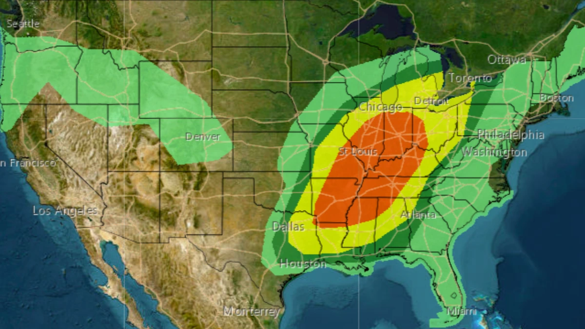
Large hail, heavy rainfall, and the potential for strong tornadoes are forecast across parts of the central and eastern United States this weekend. The Storm Prediction Center has issued an Enhanced Risk for severe thunderstorms stretching from Texas to Ohio, placing millions under threat.
Convective outlook for March 30, 2025. Credit: NWS/SPC
A strong upper-level trough accompanied by a low pressure system is forecast to bring severe weather conditions, heavy rains, and winter weather to much of the central and eastern U.S. through the weekend.
Severe thunderstorms are expected to develop from northern Texas to the mid/lower Mississippi Valley, along with lower Ohio and Tennessee Valleys, through Sunday afternoon into the night, March 30.
The greatest threat would be a large hail of over 6.3 cm (2.5 inches), along with the risk of strong tornadoes and damaging gusts. Most of the thunderstorm activity is forecast to be concentrated in the mid-Mississippi Valley, Lower Ohio Valley into the mid-south.

The strengthening low pressure system was located over the Central Plains in the lee of the Rockies on Saturday morning, March 29. It is forecast to move northeast towards the Midwest and Great Lakes region through the weekend.
Scattered showers and thunderstorms will be possible in the Midwest and the Great Lakes region along the frontal boundary of a quasi-stationary system extending east through the Midwest/Great Lakes into the Northeast on Saturday.
A separate area of more widespread showers and thunderstorms will also continue ahead of a leading upper wave over the Lower Mississippi/Tennessee Valleys and central Gulf Coast. Locally heavy rains and flash flooding could occur in parts of the Gulf Coast due to plentiful moisture in the region.
Increasing moist southerly flow will lead to the expansion of showers and thunderstorms along and ahead of a cold front moving east across the central/Southern Plains and into the Mississippi/Ohio Valleys later on Saturday.
Increasing shear and instability along the cold front as the upper-level trough progresses eastward may lead to a few more intense thunderstorms from the central/southern Plains into the Lower Missouri Valley.
A pair of upper-level shortwaves passing over the region paired with a return flow of moisture from the deep Gulf region, will bring a more significant severe weather conditions to the region through Sunday.
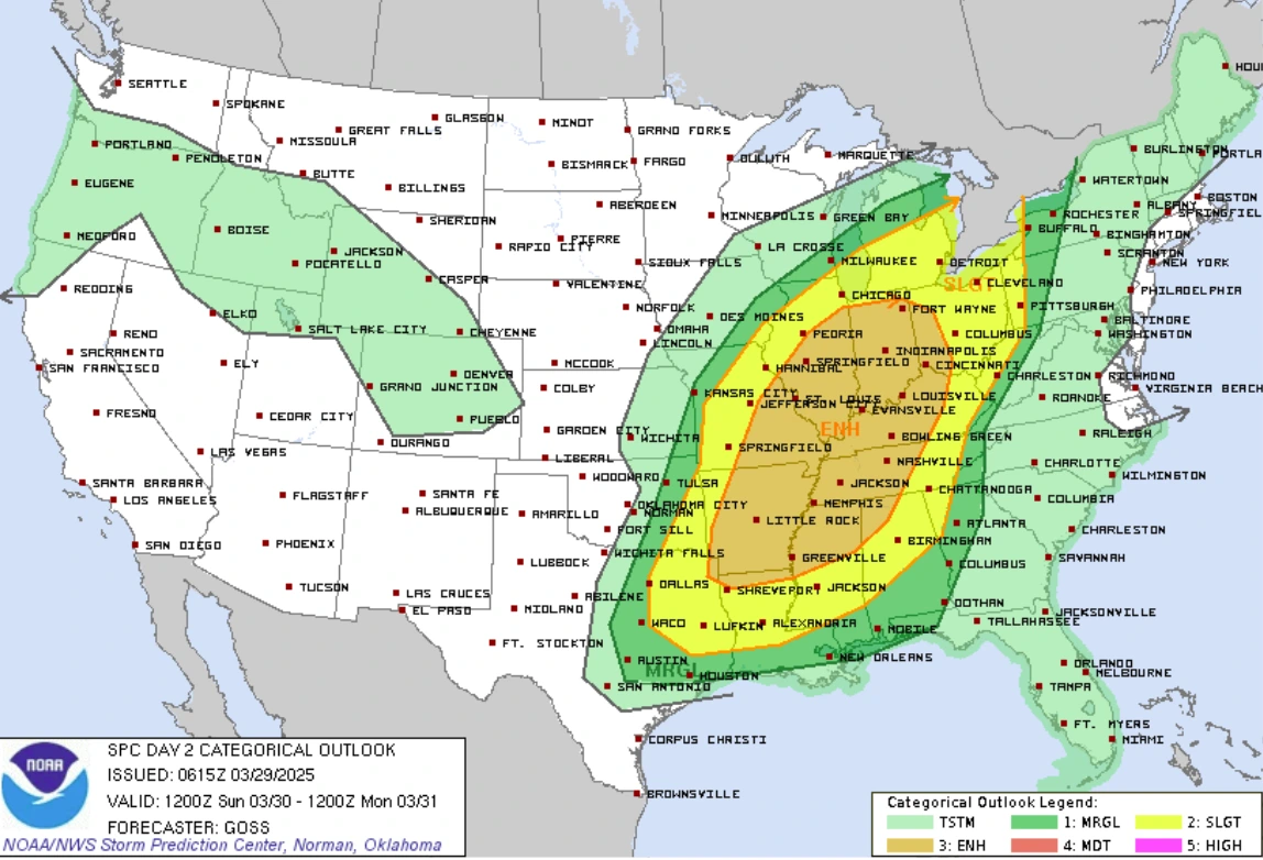
The Storm Prediction Center (SPC) issued a broad Enhanced Risk (level 3/5) for very large hail, destructive winds, and the possibility of strong tornadoes. The risk zone covers an area of nearly 608 650 km2 (235 000 miles2), affecting nearly 26 million people.
Some of the most populous regions under the Enhanced Risk are Indianapolis, Indiana; St. Louis, Missouri; Cincinnati, Ohio; as well as Memphis and Nashville, Tennessee.
The Storm Prediction Center (SPC) has also issued a Slight Risk of severe weather (level 2/5) mainly for the threat of some large hail and damaging winds. The risk zone covers an area of over 739 440 km2 (285 500 miles2), affecting nearly 46 million people.
Some of the most populated areas under Slight Risk are: Chicago, Illinois; Detroit, Michigan; Pittsburgh, Pennsylvania, along with Columbus and Cleveland, Ohio.
Widespread storms are expected ahead of the front during the day Sunday as it continues moving east into the Middle/Lower Mississippi, Tennessee, and Ohio Valleys.
References:
1 Short Range Forecast Discussion – NWS/WPC – March 29, 2025

I am an Assistant Editor and Severe Weather & Science Journalist at The Watchers, specializing in real-time severe weather coverage, geophysical event reporting, and research-driven scientific analysis. You can reach me at rishav(at)watchers(.)news.
Commenting rules and guidelines
We value the thoughts and opinions of our readers and welcome healthy discussions on our website. In order to maintain a respectful and positive community, we ask that all commenters follow these rules.