
Three successive atmospheric rivers to impact much of the Pacific Northwest
Three atmospheric rivers (ARs) are forecast to impact the Pacific Northwest (PNW) from Wednesday, March 19, 2025, into early next week, bringing significant precipitation and potential excessive rainfall to Oregon and Washington.
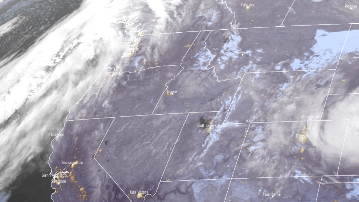
Satellite image of the AR off the US West Coast as of 10:00 UTC on March 19, 2025. Image credit: GOES-19, RAMMB/CIRA, The Watchers
A weakening atmospheric river (AR) with south-southwesterly Integrated Vapor Transport (IVT) is expected to make landfall and move across the Pacific Northwest (PNW) on March 19.
A short-duration, weak AR will follow on March 20, associated with westerly IVT exceeding 250 kg m⁻¹ s⁻¹, and is forecast to persist for approximately 30 hours.
Another AR is forecast to make landfall over the PNW on March 22 and continue into early next week. Forecast uncertainty remains in both the ECMWF and GFS models regarding its exact location, duration, and intensity.
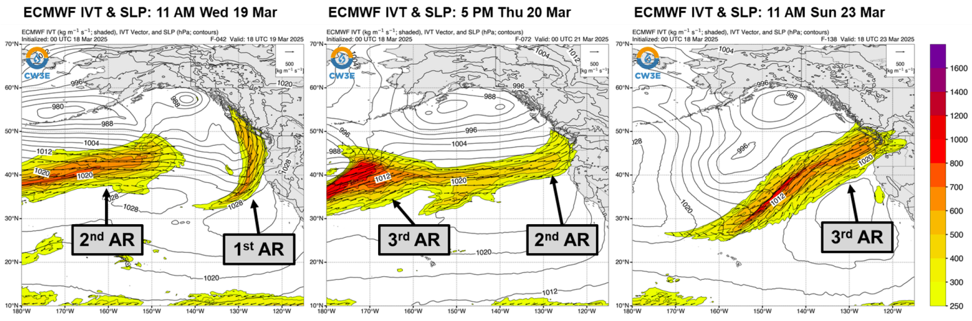
The effects of these ARs are expected to remain concentrated over the northern U.S. West Coast (USWC) due to an offshore ridge developing near California, which will keep the southern USWC drier.
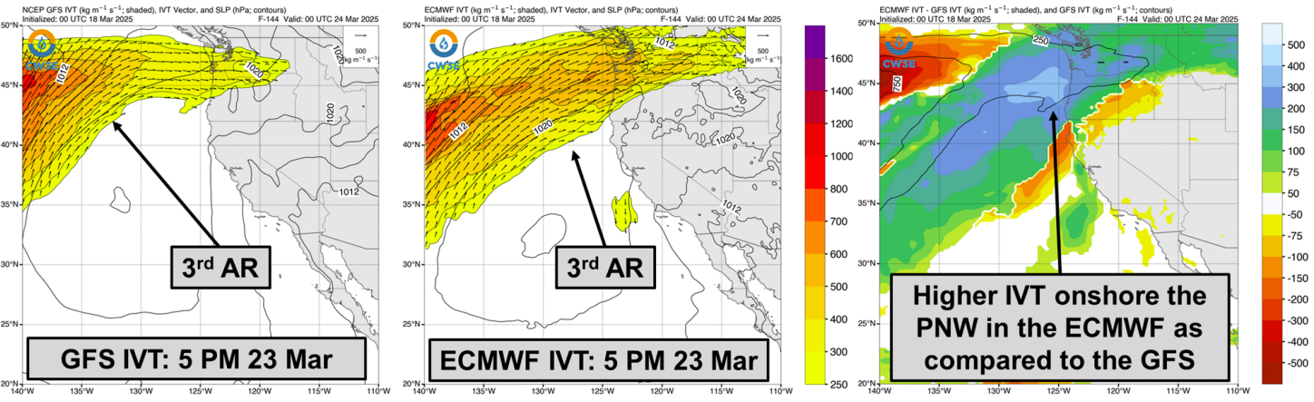
The Center for Western Weather and Water Extremes’ (CW3E) AR landfall tools indicate notable differences in the probability of IVT exceeding 250 kg m⁻¹ s⁻¹ over the USWC.
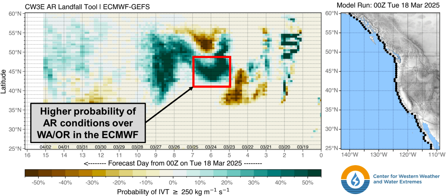
The EPS/ECMWF model suggests a higher likelihood of stronger AR conditions over Oregon and Washington compared to the GEFS/GFS model between March 22 and 24.
For the third AR, the 00Z GEFS model indicates a low probability (approximately 25%) of AR 1 conditions. In contrast, the 00Z EPS model projects a high probability (over 70%) of AR 2 conditions and about a 40% chance of AR 3 conditions.

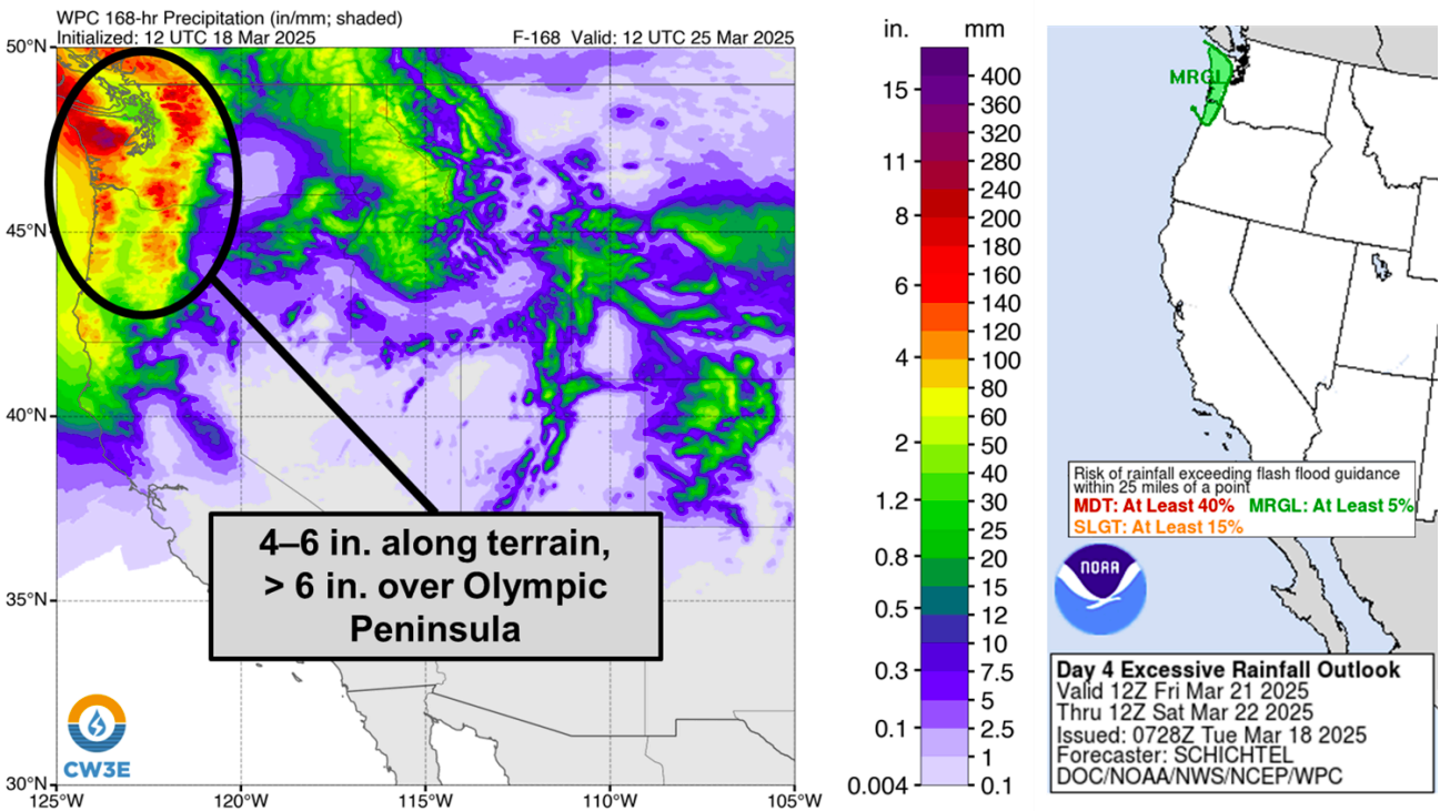
The National Weather Service (NWS) Weather Prediction Center (WPC) forecasts 7-day precipitation totals of 100–150 mm (4–6 inches) along the coastal mountains of Oregon and Washington, as well as the Cascades. Precipitation amounts exceeding 150 mm (6 inches) are expected over the Olympic Peninsula terrain by March 25.
The NWS WPC has issued a marginal risk excessive rainfall outlook (ERO) for coastal northwest Oregon and Washington following the second AR’s landfall.
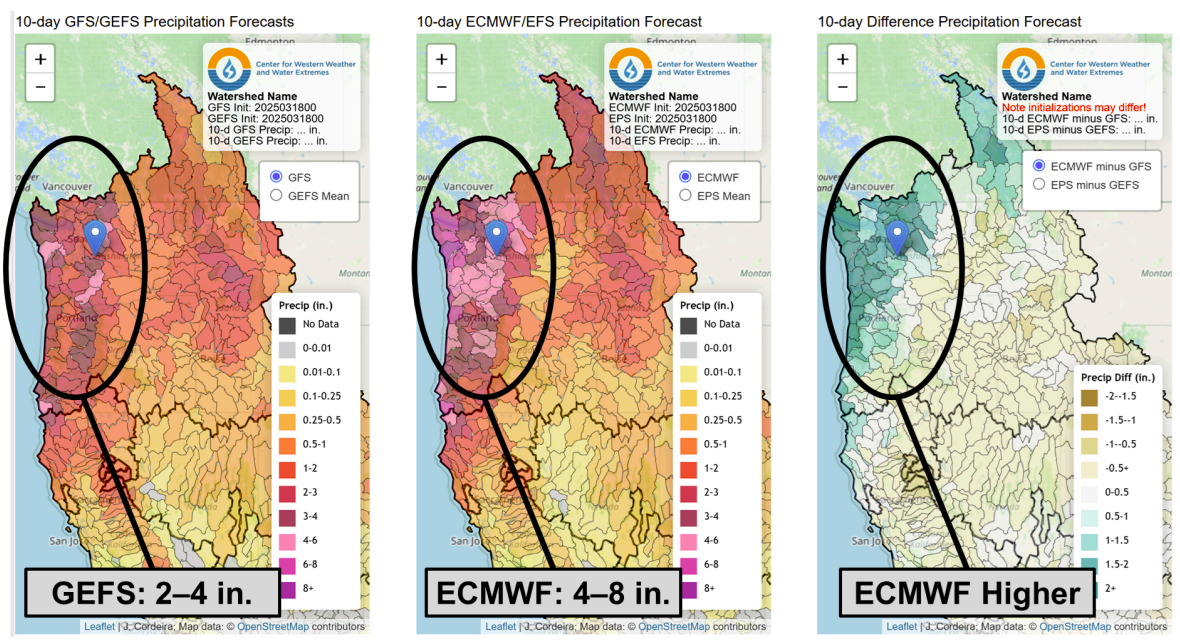
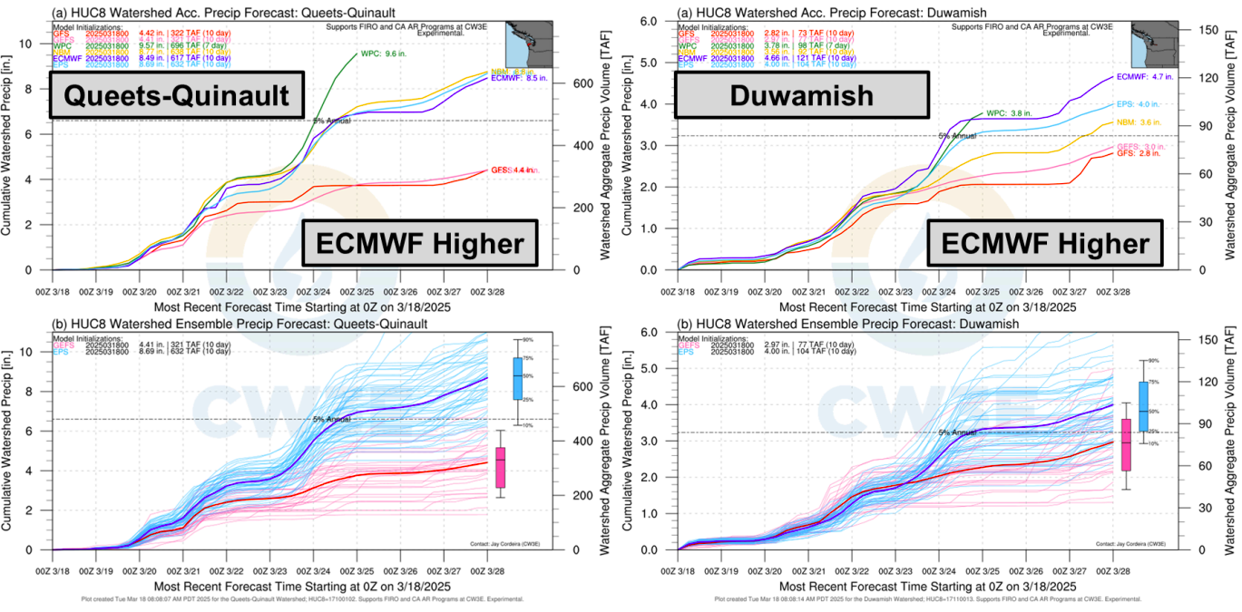
Model-based quantitative precipitation forecasts indicate uncertainty regarding the third AR. In coastal Washington, the ECMWF/EPS projects 216 mm (8.5 inches) of precipitation over the Queets-Quinault watershed, nearly double the 114 mm (4.5 inches) forecasted by the GFS/GEFS.
A similar discrepancy is observed inland over the Duwamish watershed, where the ECMWF/EPS forecasts approximately 114 mm (4.5 inches) of precipitation, compared to around 76 mm (3 inches) projected by the GFS/GEFS.
An atmospheric river is a long, narrow band of concentrated moisture in the atmosphere that transports large amounts of water vapor from tropical or subtropical regions toward higher latitudes. When these systems make landfall, they can produce heavy rainfall, strong winds, and potential flooding, especially in coastal and mountainous areas.
References:
1 Quick Look at the Upcoming AR Activity and Impacts over the US West Coast – CW3E – March 18, 2025

I am an Assistant Editor and Severe Weather & Science Journalist at The Watchers, specializing in real-time severe weather coverage, geophysical event reporting, and research-driven scientific analysis. You can reach me at rishav(at)watchers(.)news.
Commenting rules and guidelines
We value the thoughts and opinions of our readers and welcome healthy discussions on our website. In order to maintain a respectful and positive community, we ask that all commenters follow these rules.