
Blizzard conditions, tornadoes, and fire weather threats as powerful storm moves across U.S.
Millions are bracing for a major storm system forecast to bring severe weather across the U.S., including damaging winds, heavy snowfall, and the threat of tornadoes. The system is set to bring blizzard conditions to the West, severe thunderstorms to the Midwest, and critical fire weather to the Southern Plains, impacting millions through the weekend.
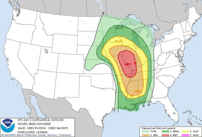
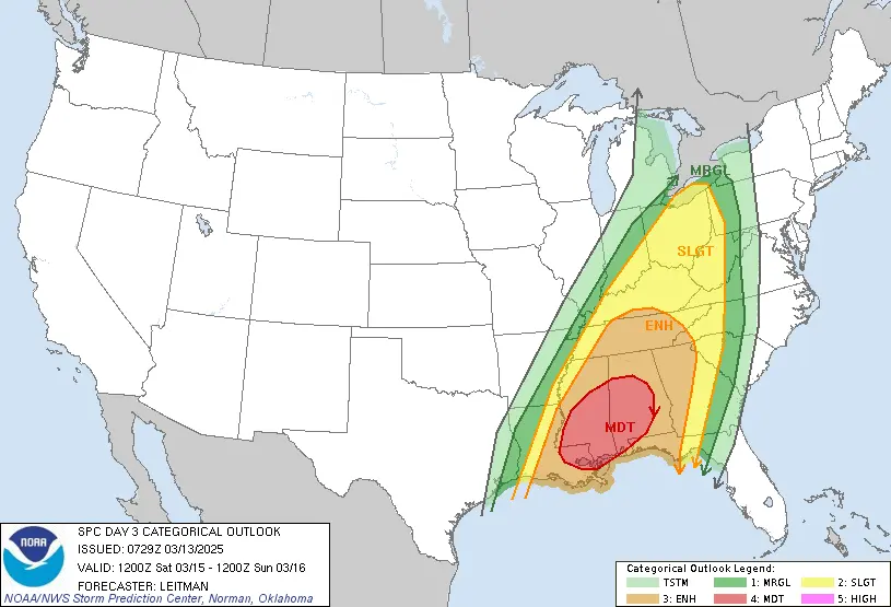
Convective outlook ending at 17:00 EST on March 15, 2025. Image credit: NWS/SPC
According to the National Weather Service (NWS), a severe weather outbreak is expected across the U.S. through the weekend.
A powerful upper-level trough will bring damaging winds, heavy mountain snowfall, rainfall, and cooler temperatures to much of the West through the end of the week.
Heavy snowfall and powerful wind gusts of 64–113 km/h (40–70 mph) below many major passes will create dangerous to potentially impossible travel conditions across the Sierra Nevada and northern California’s higher terrain on Thursday, March 13.
Snowfall exceeding 61 cm (2 feet), combined with high winds, could cause scattered power outages. Additionally, heavy rainfall may lead to flash flooding across portions of southern California through Thursday night.
Heavy snowfall above 1 500 m (5 000 feet) and strong winds will cause widespread hazardous travel conditions in the southern Intermountain West and Rockies on Thursday and Friday.
The system will rapidly strengthen as it moves northeast over the Great Plains from Friday to Saturday, March 14–15, resulting in widespread high winds and increasing snowfall coverage.
Dangerous travel conditions are likely in areas with blowing snow and potential blizzard conditions. A wintry mix is also possible for parts of the Dakotas and Minnesota.
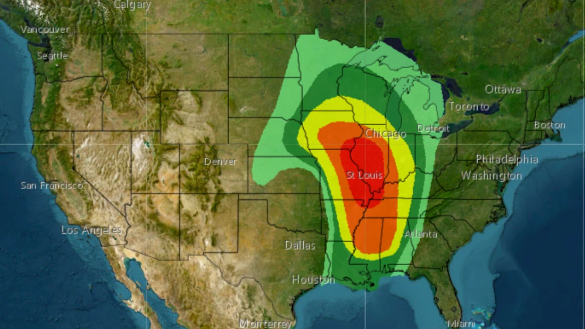
The system is expected to produce a severe weather outbreak across much of the Mississippi Valley and parts of the western Ohio and Tennessee Valleys.
The Storm Prediction Center (SPC) has issued a Moderate Risk (level 4/5) for severe thunderstorms across eastern Missouri, far southeastern Iowa, central and southern Illinois, far western Kentucky, far northwestern Tennessee, and extreme northeastern Arkansas. Widespread damaging winds, several tornadoes, and large hail will be possible late Friday afternoon and evening.
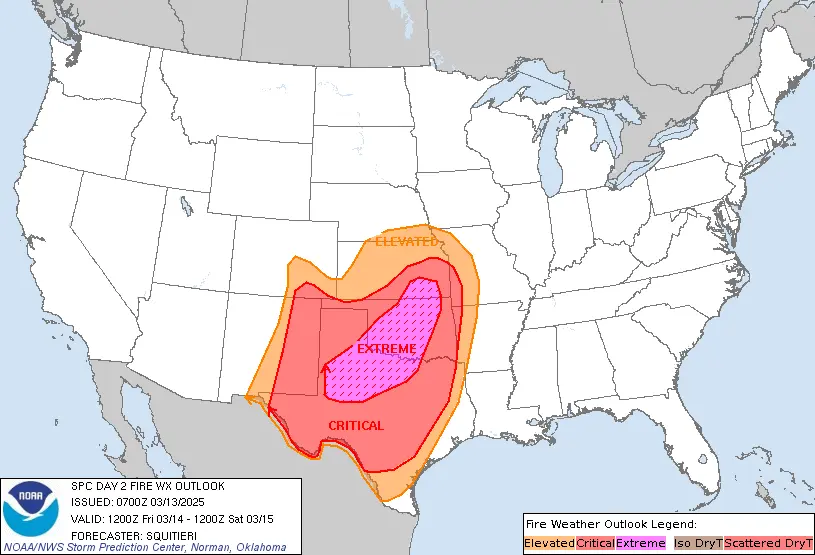
This system will also pull warm, dry air from the Desert Southwest into the Southern Plains, where a tightening pressure gradient will generate strong winds and an increased fire weather risk.
The SPC has issued a Critical Fire Weather Risk area across much of the Southern Plains through the weekend. Red Flag Warnings and High Wind Warnings are also in effect for much of the Southern High Plains.
A deep southerly flow into the Plains ahead of the developing system will lead to potentially record-breaking temperatures for parts of the Northern Plains, Upper Midwest, and southeastern Texas through Friday.
High temperatures ranging from 16–27°C (60s–70s°F) in the Upper Midwest and Northern Plains will be 11– 22°C (20–40°F) above average.
In Texas, highs of 27–37°C (80s– 90s°F) will be 11–17°C (20–30°F) above normal. This warm air will push into the East Coast during the weekend. Meanwhile, high temperatures in the West will remain well below average under the amplified upper trough late in the week.
References:
1 Short Range Forecast Discussion – NWS/SPC – March 13, 2025

I am an Assistant Editor and Severe Weather & Science Journalist at The Watchers, specializing in real-time severe weather coverage, geophysical event reporting, and research-driven scientific analysis. You can reach me at rishav(at)watchers(.)news.
Commenting rules and guidelines
We value the thoughts and opinions of our readers and welcome healthy discussions on our website. In order to maintain a respectful and positive community, we ask that all commenters follow these rules.