
Ice storm warnings and winter weather advisories issued across Oregon
An Ice Storm Warning has been issued for the Central and Southern Willamette Valley, the Central Oregon Coast Range Lowlands, and the Central Oregon Coast Range. The warning will be in effect from 01:00 local time (LT) on February 13 to 04:00 LT on February 14, 2025, with significant ice and snow accumulation expected.
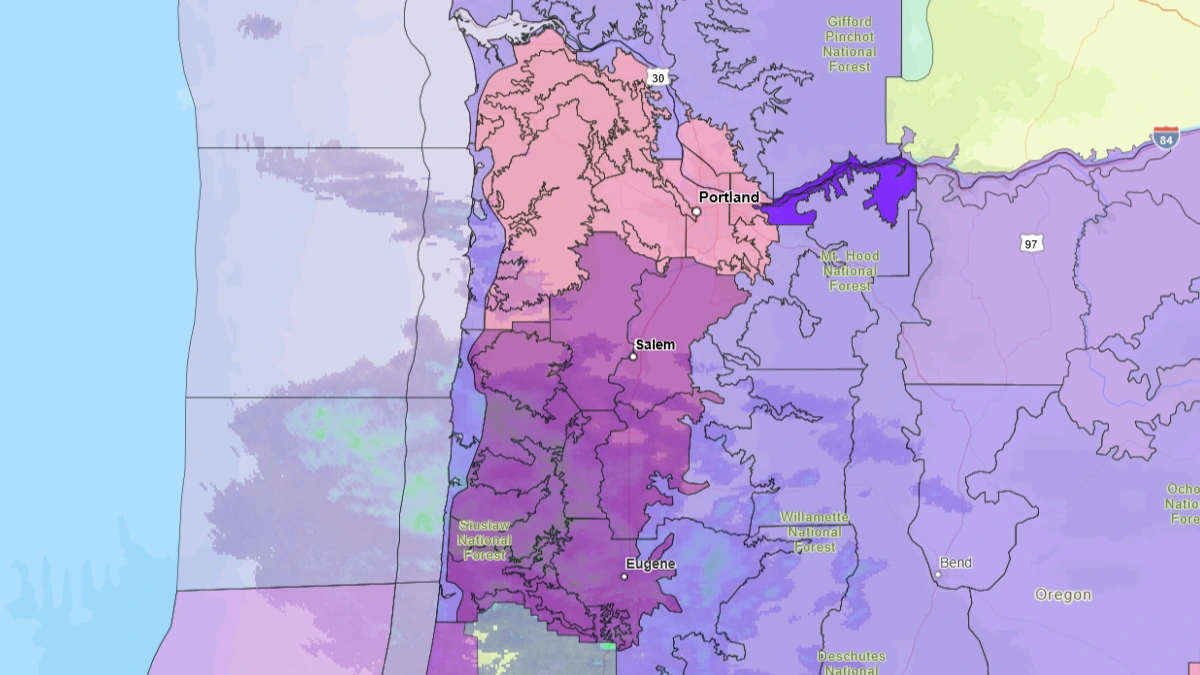
Warning area graphic for Oregon from Thursday into Friday, February 13 to 14, 2025. Image credit: NWS
An Ice Storm Warning has been issued for the Central and Southern Willamette Valley, the Central Oregon Coast Range Lowlands, and the Central Oregon Coast Range as winter storms affect large parts of the United States.
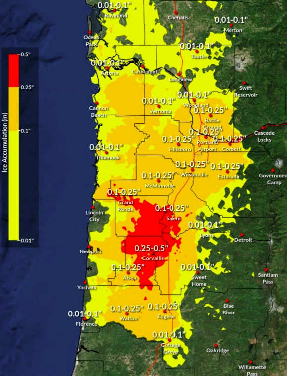
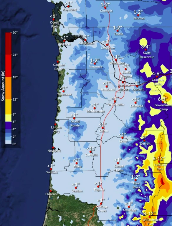
The warning will be in effect from 01:00 on Thursday, February 13 to 16:00 on Friday, February 14. Significant ice accumulation of up to 0.76 cm (0.3 inches) and snow accumulation of up to 2.5 cm (1 inch) are expected.
While most areas will see snow accumulation of up to 2.5 cm (1 inch), isolated totals of up to 20.3 cm (8 inches) are possible in locations such as Santiam Pass.
The storm will create hazardous travel conditions due to icy roads, especially on bridges and overpasses. The National Weather Service (NWS) advises against travel unless necessary.
“If you leave the safety of being indoors, you are putting your life at risk,” the NWS stated.
Ice accumulation will begin early Thursday afternoon in the Portland and Vancouver metro areas, while snow accumulation is expected to start at approximately 02:00 on Thursday.
In the Central and Southern Willamette Valley, ice accumulation will begin at approximately 02:00 on Thursday and continue until 08:00, while snow accumulation will persist from 02:00 to 05:00.
In Central Oregon, ice accumulation will begin at 02:00 on Thursday and continue until 08:00. In northern Oregon and southwestern Washington, it will begin at 08:00 and last until 12:00. Snow accumulation is expected to continue from 02:00 to 08:00 across the entire region.
A Cold Weather Advisory has been issued until Thursday noon for the following areas: Northern and Central Cascades and Foothills in Oregon, Central and Southern Willamette Valley, South Washington, North and Central Oregon Coast, Northern and Central Coast Range Valleys and Mountains of Oregon, Willapa Hills and adjacent river valleys of Pacific and Wahkiakum Counties, Lower Columbia River and Cowlitz River Valleys, South Washington Cascades and Foothills, and Outer Southeast Portland Metro.
Areas under the advisory will experience wind chills with temperatures dropping to as low as -12.2 to -3.9 °C (10 to 25 °F). The NWS warned of the risk of hypothermia and advised people to stay indoors and dress appropriately to prevent frostbite and hypothermia.
References:
1 Watches, Warnings & Advisories – NWS – February 12, 2025

I am an Assistant Editor and Severe Weather & Science Journalist at The Watchers, specializing in real-time severe weather coverage, geophysical event reporting, and research-driven scientific analysis. You can reach me at rishav(at)watchers(.)news.
Commenting rules and guidelines
We value the thoughts and opinions of our readers and welcome healthy discussions on our website. In order to maintain a respectful and positive community, we ask that all commenters follow these rules.