
Flash Flood Warnings issued for Dallas as powerful cross country storm sweeps through the U.S.
Parts of Texas and the Northern Gulf Coast will experience a bout of severe weather this week as a powerful cross-country storm sweeps through the south-central U.S., beginning on Thursday, January 30, 2025. The storm is expected to dump heavy snow in the southwest and the Rockies. Several areas such as Dallas and Arlington are already under Flood Watches and Warnings.

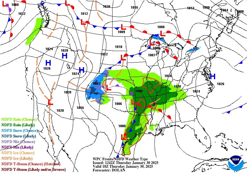
Convective outlook for cross country storm. Image credit: NWS/WPC
- A powerful cross-country storm will impact the south-central United States on January 30, moving east and northeast on January 31.
- Areas in Texas, including Dallas, Arlington, and Plano, have already received significant rainfall, with flash flood warnings issued. Strong winds up to 89 km/h (55 mph) and pea-sized hail have also been reported.
- Strong to severe thunderstorms are expected from east Texas through the Lower Mississippi Valley, bringing damaging winds, hail, and possible tornadoes.
- A weather front arriving on January 31 will bring widespread rainfall and heavy snowfall to the Northwest, northern California, and the northern Rockies, increasing the risk of flooding in steep terrain.
A powerful cross-country storm is expected to move through the south-central United States on January 30 before tracking east and northeast on January 31.
A line of thunderstorms was already moving through parts of Texas, including Dallas and Fort Worth, on Thursday morning, with heavy rain as the main threat, along with strong to marginally severe thunderstorms, according to the National Weather Service (NWS).
Flood watches and warnings have been issued across Texas and several other states due to the storm. Strong winds of up to 90 km/h (55 mph) have been reported, along with pea-sized hail in areas such as Killeen, Belton, and Temple, Texas.

Dallas, Arlington, and Plano, Texas, along with several other areas, were under a flash flood warning on Thursday morning due to the storm.
Several areas have already received significant rainfall due to the storm. Grand Prairie recorded 113 mm (4.45 inches) of rain by 05:00 local time (LT) on Thursday morning. Mesquite Airport reported 110 mm (4.32 inches) during the same period, while Farmers Branch, Texas, recorded 101 mm (3.98 inches).
Storm forecast
On Thursday, widespread showers and thunderstorms are expected across the Southern Plains and Mississippi Valley as southerly winds bring warm, moist air from the Gulf of Mexico, intensifying severe weather conditions.
Strong to severe thunderstorms are likely from east Texas through the Lower Mississippi Valley on Thursday. Potential hazards include damaging winds, hail, and possible tornadoes.
Heavy rainfall may cause isolated to scattered instances of flash flooding from east Texas through the Mississippi Valley into the Lower Ohio Valley.
As thunderstorms impact the south-central United States, cold air behind the storm system will bring wintry weather to New Mexico and Colorado, with the potential for heavy snowfall in higher elevations.
On Friday, the system will weaken as it moves east and northeast. Precipitation is expected to increase across most areas east of the Mississippi River. The risk of severe weather will shift to the central and eastern Gulf Coast, where strong storms are possible.
By late Friday, moisture from this system will reach the Northeast and interact with a cold front, bringing wintry weather to the eastern Great Lakes and Northeast. However, snow accumulation is expected to be minimal, particularly in New England. The system will move off the East Coast by the morning of February 1, bringing dry conditions.
Dry conditions will persist in the western United States until a weather front arrives late on Thursday.
This front will move into the Northwest on Friday, followed by another front late on Friday into Saturday, February 1.
Widespread rainfall is expected in the Northwest, northern California, and the northern Rockies, increasing the risk of flooding, particularly in steep terrain. Additionally, heavy snowfall is anticipated in the Olympic Mountains, Cascades, northern Rockies, and possibly parts of the Sierra Nevada.
The severe weather will create difficult travel conditions through the weekend across the country, with snow, rain, and strong winds sweeping across much of the south-central United States.
References:
1 Short Range Public Discussion – NWS/WPC – January 30, 2025

I am an Assistant Editor and Severe Weather & Science Journalist at The Watchers, specializing in real-time severe weather coverage, geophysical event reporting, and research-driven scientific analysis. You can reach me at rishav(at)watchers(.)news.
Commenting rules and guidelines
We value the thoughts and opinions of our readers and welcome healthy discussions on our website. In order to maintain a respectful and positive community, we ask that all commenters follow these rules.