
Severe Thunderstorm outbreak and Excessive Rainfall potential from the Southern Plains to Southeast today
Severe thunderstorms and tornadoes are forecast to begin in the Southeast on Saturday, December 28, 2024, as a developing low-pressure system threatens to produce severe storms across Eastern Texas, Louisiana, and the Lower Mississippi Valley.
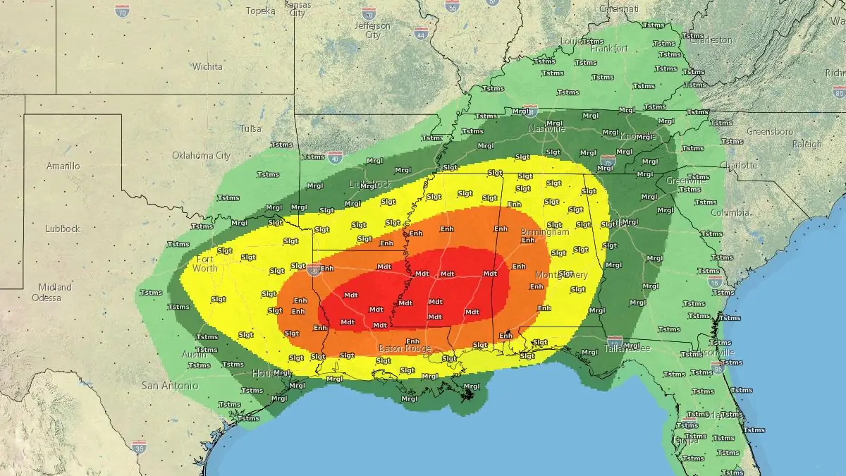
Image credit: NWS, The Watchers
- A developing low-pressure system in the Southeast is expected to produce severe thunderstorms, damaging winds, large hail, and long-track tornadoes across multiple regions, beginning on Saturday.
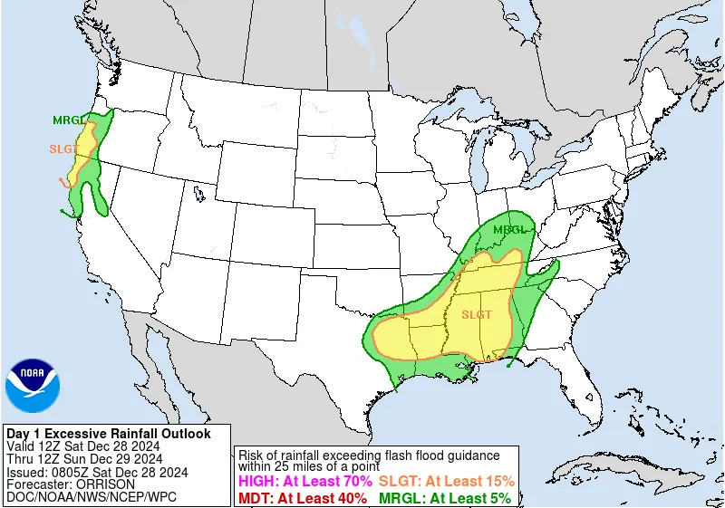
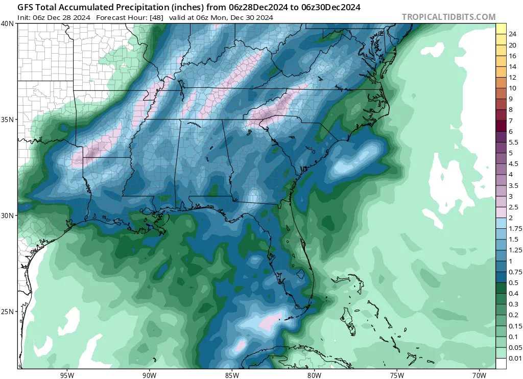
- Rainfall rates of 50 – 76 mm (2 – 3 inches) per hour could lead to accumulations exceeding 130 mm (5 inches) in some areas, posing significant flooding risks in the Mississippi Valley and Mid-Atlantic.
- Eastern Texas, Louisiana, southern Arkansas, and Mississippi face the highest risk, with strong winds up to 110 km/h (70 mph) and the potential for supercell thunderstorms.
A developing low-pressure system in the Southeast is expected to bring severe thunderstorms, heavy rainfall, and possible tornadoes throughout the weekend, beginning on Saturday, December 28.
The system is expected to result in severe weather, including an outbreak of storms causing wind damage and large hail across the southern plains, the lower Mississippi Valley, and the central Gulf Coast states.
Warm, unstable air is already present in parts of south-central to southeast Texas and southern Louisiana, with potential energy values (MLCAPE) ranging from 1 500 to 2 500 J/kg. This air mass will move northward by midday Saturday as a warm front advances ahead of the approaching low-pressure system.
Several long track tornadoes are expected. Thus, a Moderate Risk (level 4/5) of Severe Thunderstorms was hoisted. Additionally, a Slight Risk (at least 15%) of Excessive Rainfall is in effect for a similar area to the SPC Slight, but extending farther into the Tennessee Valley.
By midday Saturday and into the afternoon, strong thunderstorms, including supercell thunderstorms, are expected to develop in eastern Texas, spreading to the Arklatex region and the Lower Mississippi Valley by the evening. Weather models indicate that low-level winds may intensify to 75 – 110 km/h (47 – 68 mph) in eastern Texas, Louisiana, southern Arkansas, and parts of Mississippi by midnight.
As the warm front lifts, it is likely to become a focal point for widespread thunderstorms, resulting in several rounds of heavy rainfall over the same areas.
An isolated flooding threat is likely in the Mississippi Valley on Saturday and the Mid-Atlantic on Sunday as moisture streams northward with the developing low-pressure system.
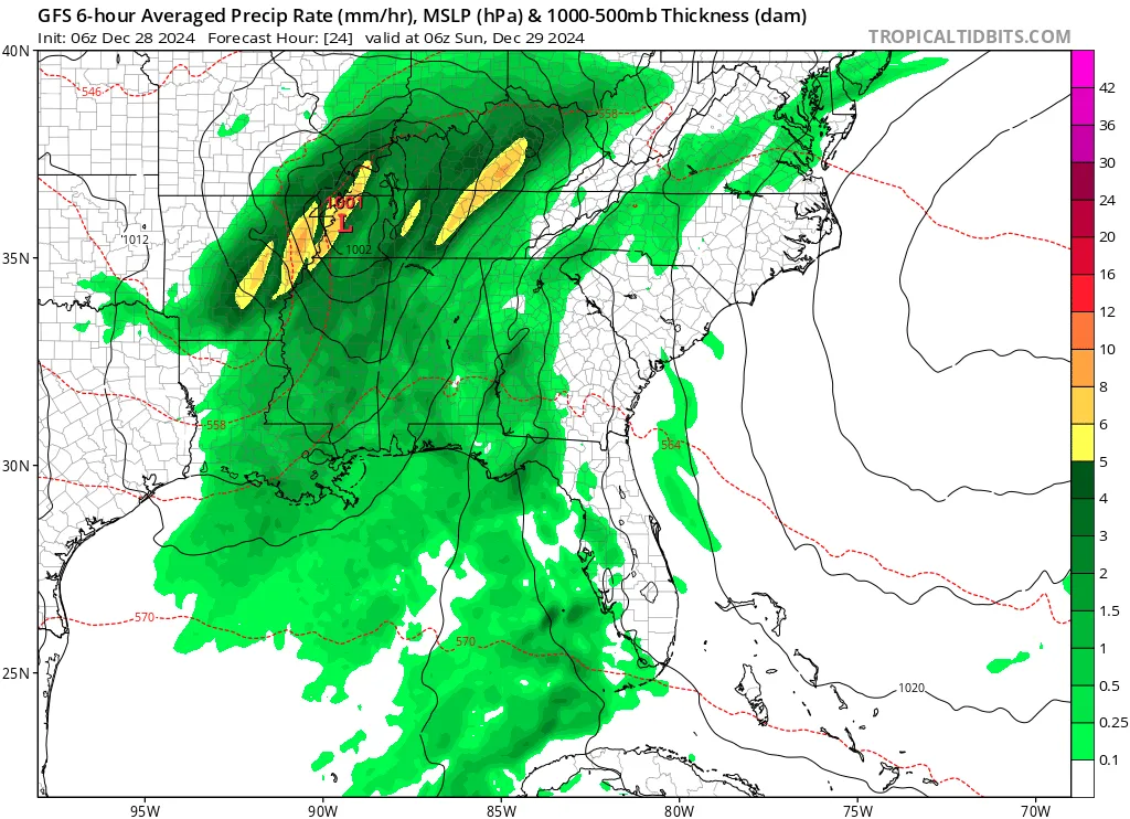
With high moisture levels, instability, and strong wind shear, some thunderstorms may produce rainfall rates of 50 – 76 mm (2 – 3 inches) per hour.
There is a risk of storms merging and repeatedly affecting the same regions, potentially leading to total rainfall accumulation of 50 – 100 mm (2 – 4 inches), with isolated areas receiving more than 130 mm (5 inches) by Saturday evening.
Several long-track tornadoes are anticipated in the Southeast during this period of severe weather. The Storm Prediction Center (SPC) has issued a moderate risk (level 4 out of 5) for severe thunderstorms.
There is a 15% probability of excessive rainfall, extending into the Tennessee Valley. Rain and severe thunderstorms are expected to move toward the East Coast on Sunday, December 29.
Two tornadoes and a waterspout have already been reported in Alabama on Friday, December 27, a day after five tornadoes swept through Texas.
References:
1 Short Range Forecast Discussion – NWS/WPC – December 28, 2024
2 WPC Day 1 Excessive Rainfall Outlook – NWS/WPC – December 28, 2024

I am an Assistant Editor and Severe Weather & Science Journalist at The Watchers, specializing in real-time severe weather coverage, geophysical event reporting, and research-driven scientific analysis. You can reach me at rishav(at)watchers(.)news.
Commenting rules and guidelines
We value the thoughts and opinions of our readers and welcome healthy discussions on our website. In order to maintain a respectful and positive community, we ask that all commenters follow these rules.