
Strong East Coast atmospheric river forecast to bring heavy rain and snowmelt to Northeast
A strong atmospheric river (AR) is set to impact the Southeastern and Northeastern U.S. this week, bringing anomalously high moisture levels and the potential for heavy rainfall and rapid snowmelt. Forecasts indicate the system will strengthen between December 10 and 11, driven by a plume of tropical moisture from the Gulf of Mexico and a cold front. Continued strengthening is forecast for December 11 as the system moves offshore of the East Coast. This AR could rank among the strongest in decades for the Northeast, comparable to the December 2023 event that caused significant flooding in the region. Residents are urged to prepare for potential flood risks as the system moves offshore and intensifies.

Image credit: NOAA/GOES-East, RAMMB/CIRA, The Watchers. Acquired at 20:40 UTC on December 10, 2024
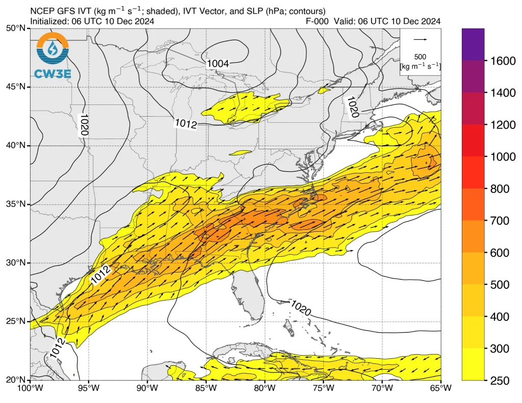
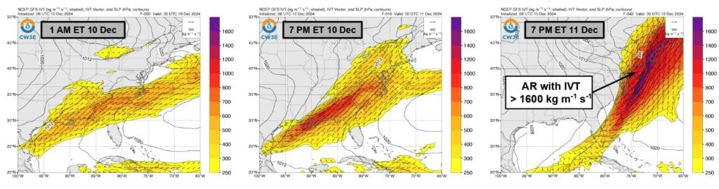
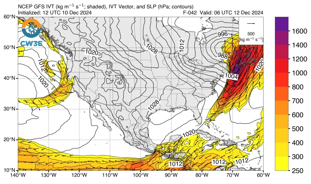
- GEFS and EPS weather models are showing a lot of confidence that a huge amount of water vapor will flow through the atmosphere over Providence, Rhode Island, during this event. This flow of moisture is measured as “IVT” (Integrated Vapor Transport), and it’s predicted to be very high—higher than 1 000 units in some areas, and potentially reaching extreme levels over 1 600 units in others.
- If these predictions hold, this storm would be one of the strongest “atmospheric rivers” (ARs) to hit this area since 1959, according to the Center for Western Weather and Water Extremes (CW3E).
- It would also be the most intense event not related to a tropical storm since December 18, 2023, which caused severe flooding in the Northeast.
A strong atmospheric river is forming over the southeastern United States, carrying substantial tropical moisture along the East Coast. This system is predicted to affect regions from the Mid-Atlantic to New England, with notably high moisture transport expected in areas such as Providence, Rhode Island.
Forecast models from the GEFS and EPS ensembles indicate a high probability of intense Integrated Vapor Transport (IVT). Specifically, IVT values exceeding 1 000 kg m⁻¹ s⁻¹ are anticipated over Providence, RI, with some ensemble members projecting peak IVT values surpassing 1 600 kg m⁻¹ s⁻¹.
This level of moisture transport places the event among the top 14 strongest atmospheric rivers to affect the area since 1959 and marks the most significant non-tropical IVT event since December 18, 2023.
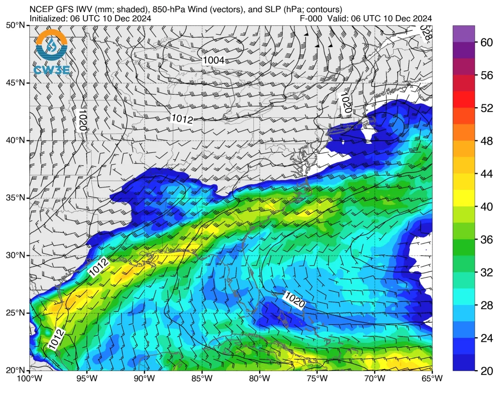
The event is linked to exceptionally high Precipitable Water (PWAT) values, in the 99.5th percentile based on a three-week analysis. These elevated moisture levels signal the likelihood of significant precipitation and hydrological impacts.
The National Weather Service’s Weather Prediction Center (NWS WPC) forecasts widespread 72-hour rainfall totals exceeding 38 mm (1.5 inches) across the eastern United States.
Localized areas, particularly in the Southeast, Mid-Atlantic, and New England, could receive 76 – 127 mm (3 – 5 inches) of rain. This forecast has led to marginal and slightly excessive rainfall outlooks being issued for December 10 – 12.
“A developing storm system over the Southeast U.S. is set to bring widespread heavy rains from the central and eastern Gulf Coast to the entire East Coast tonight into Wednesday,” NWS forecaster Miller noted on December 10.
“A wave of low pressure will rapidly strengthen and move northeastward across the interior Mid-Atlantic and Northeast, dragging a strong cold front along with it,” Miller said.
Ahead of the front, warm and moist air will set the stage for numerous showers and thunderstorms, some of which could become strong to severe.
This is especially the case across eastern North Carolina on Wednesday, where the Storm Prediction Center has issued a Slight Risk (level 2 of 5) for severe thunderstorms capable of producing damaging wind gusts.

The main concern elsewhere along the Eastern Seaboard will be a period of heavy rain with embedded strong thunderstorms and intense downpours.
Despite much of the region currently experiencing moderate to extreme drought conditions, the rain, while mostly beneficial, could still lead to some localized instances of flash flooding. The more urbanized locations and poor drainage areas would have the greater risk of flooding issues.
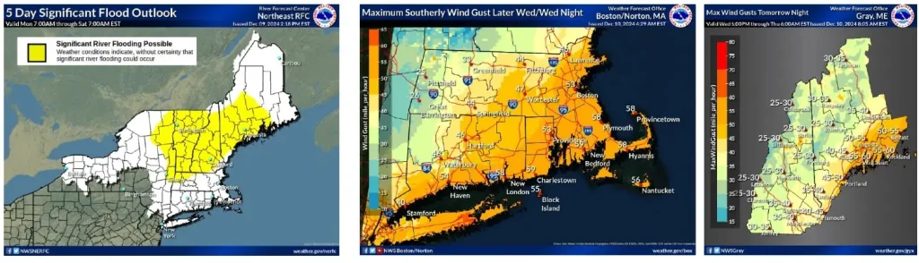
Heavy rainfall combined with warm temperatures is likely to cause rapid snowmelt across New England, significantly increasing river levels.
The NWS Northeast River Forecast Center (RFC) has issued warnings for potential widespread river flooding. The substantial rainfall, paired with reduced snowpack, could result in considerable hydrological impacts.

Strong winds are also a concern, with gusts exceeding 64 – 80 km/h (40 – 50 mph) forecast along coastal areas from New York City to northern Maine. These conditions may cause localized power outages and dangerous travel conditions in the affected regions.
The cold front will sweep across the East Coast Wednesday into Thursday, December 12, with much colder air surging in from the north and northwest in its wake.
This Arctic blast will first plunge into the northern Plains and Upper Midwest tonight, December 10, before expanding eastward across the Great Lakes, Mid-Atlantic and Northeast Wednesday and Thursday.
High temperatures over the next few days are expected to range from approximately 5 to 16 °C (10 to 30 °F) below the seasonal average.
The cold post-frontal air mass is also likely to facilitate a transition from rain to snow across the western slopes of the Appalachians, as well as interior parts of New England and the Northeast, with at least modest snow accumulations considered a reasonable possibility.
The cold air is forecast to exit on December 14.
References:
1 CW3E AR Update: 10 December 2024 East Coast Outlook – CW3E – December 10, 2024
2 Short Range Forecast Discussion – NWS/WPC – December 10, 2024

I am an Assistant Editor and Severe Weather & Science Journalist at The Watchers, specializing in real-time severe weather coverage, geophysical event reporting, and research-driven scientific analysis. You can reach me at rishav(at)watchers(.)news.
Commenting rules and guidelines
We value the thoughts and opinions of our readers and welcome healthy discussions on our website. In order to maintain a respectful and positive community, we ask that all commenters follow these rules.