
Northeast experiences double threat of snowmelt and rainfall, heightening flood risks, U.S.
Temperatures across the Northeast are expected to reach 4 – 10 °C (40 – 50 °F), melting significant snow accumulations from last week’s lake-effect snowstorm. Rainfall totals are forecasted to reach 75 – 125 mm (3 – 5 inches) in some areas, including the I-95 corridor.
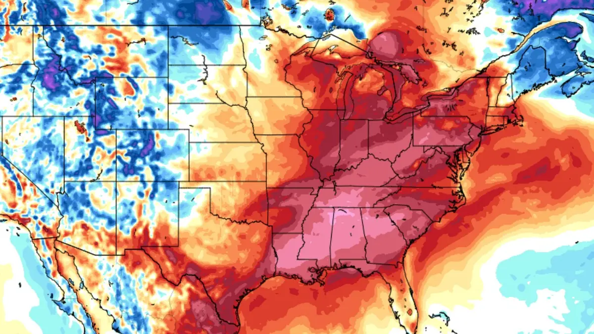
GFS 2m Temperature Anomaly for 06:00 UTC on December 10, 2024. Image credit: Tropical Tidbits
The Northeast is at risk of severe flooding this week heavy rainfall combines with warming temperatures to accelerate snowmelt.
Temperatures are expected to rise by 6 – 8 °C (10 – 15 °F) above average on Monday, December 9. In Chicago, highs are forecast to reach around 10 °C (50 °F), while the New York Metro area will see temperatures near 13 °C (55 °F). Across the Northeast, temperatures will climb to 4 – 10 °C (40 – 50 °F), though northern New England is likely to remain cooler.
The season’s first major lake-effect snowstorm, which left some areas with snow accumulations of up to 30 cm (1 foot), increases the likelihood of localized flooding as the snow melts, while heavy rains expected this week could worsen the situation.

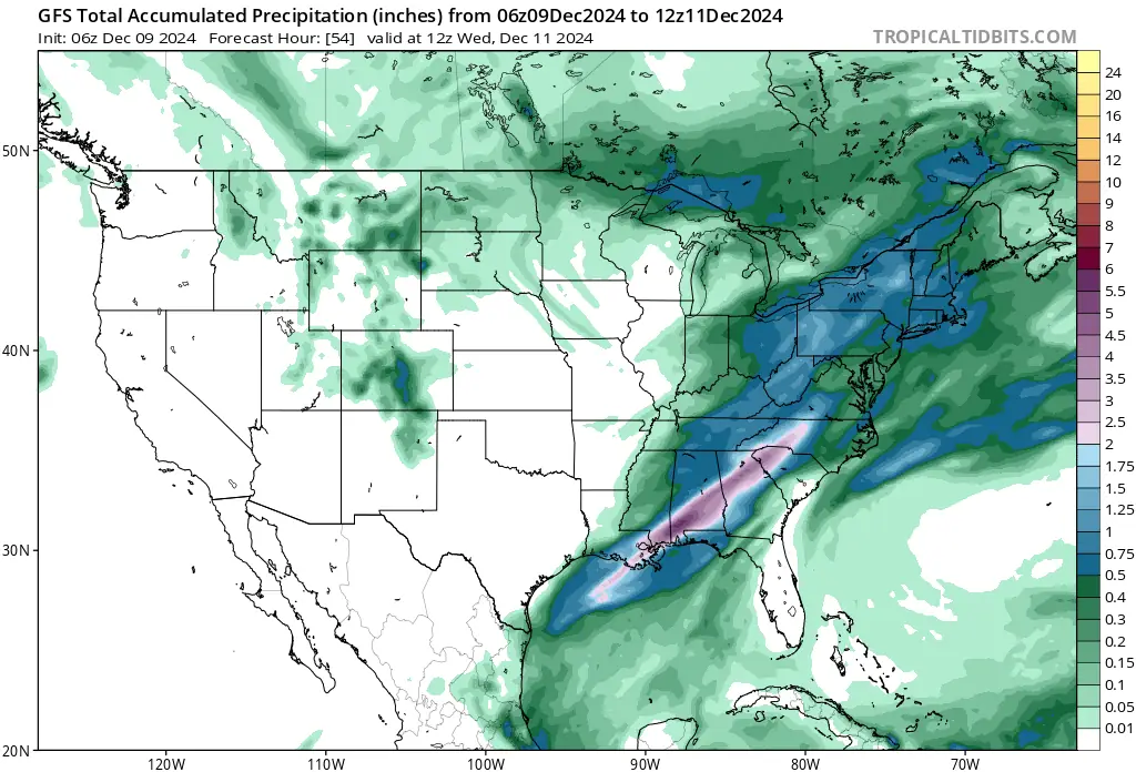
Rainfall in some areas, including the I-95 corridor from New York City through Providence, Rhode Island, and Boston, is forecast to reach several inches. Rain is set to begin on Monday, with heavier downpours later in the week.
Contributing to the flood risk is a low-pressure system moving along the U.S.-Canada border in the Midwest, which will merge with a moisture plume drawn from the Gulf of Mexico. This moisture was pulled northward as a high-pressure system shifted off Florida after delivering arctic chills to much of the South and East.
Rainfall on Monday morning will primarily affect areas west of the I-95 corridor, with heavier rainfall expected later in the afternoon and evening. A second wave of rain is forecast to develop midweek, bringing heavy precipitation to the Northeast. On Wednesday, December 11, the Weather Prediction Center has issued a Level 2 flood risk for parts of Connecticut and Maine.
Flood risk will extend into the Southeast, including Atlanta, Georgia, and Montgomery, Alabama, with the heaviest rainfall totals expected to reach 50 – 127 mm (2 – 5 inches) along a stalling front on Tuesday, December 10. Rainfall totals of 75 – 125 mm (3 – 5 inches) with localized amounts of up to 125 mm (5 inches) are possible.
Colder air is expected to move into the region on Wednesday, fueling the cold front driving the rain. This could lead to the possibility of snow by Wednesday night, though it is too early for specific forecasts.
References:
1 Millions in Northeast face flood threat from rapid snowmelt as warmer temperatures fuel soaking rains – Fox Weather -December 7, 2024
2 Atlanta, New Orleans face flash flood threat as rounds of tropical moisture will drench South – Fox Weather – December 8, 2024

I am an Assistant Editor and Severe Weather & Science Journalist at The Watchers, specializing in real-time severe weather coverage, geophysical event reporting, and research-driven scientific analysis. You can reach me at rishav(at)watchers(.)news.
Commenting rules and guidelines
We value the thoughts and opinions of our readers and welcome healthy discussions on our website. In order to maintain a respectful and positive community, we ask that all commenters follow these rules.