
Atmospheric river to impact California starting November 25, bringing new rounds of heavy rain and snow
A new atmospheric river is forecast to bring heavy rain and significant snowfall to California starting Monday, November 25, 2024, with potential flash flooding and major winter storm impacts in central and southern regions, according to the Center For Western Weather and Water Extremes (CW3E).
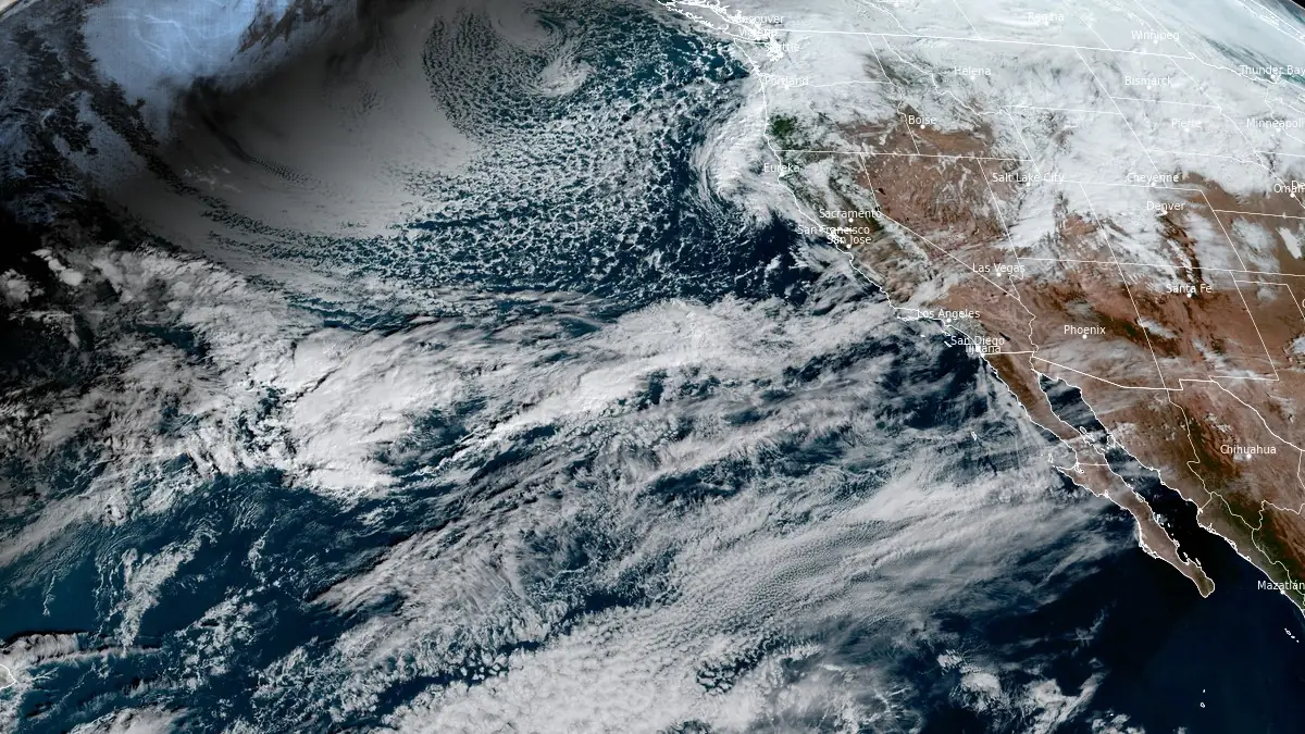
Image credit: NOAA/GOES-West, RAMMB/CIRA, The Watchers. Acquired at 17:50 UTC November 24, 2024
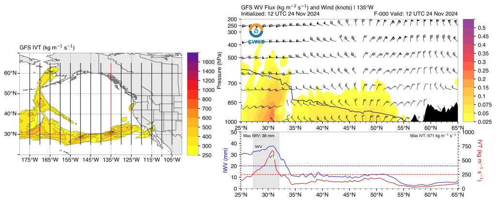
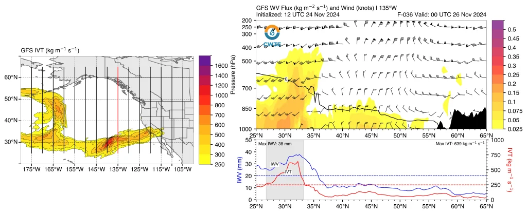
- The AR is expected to make landfall on November 25, affecting Central and Southern California and extending into the interior western United States, including the Upper Colorado River Basin.
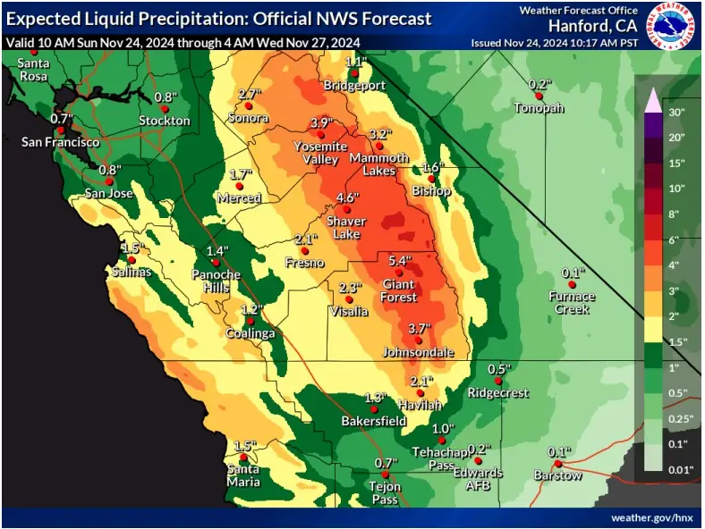
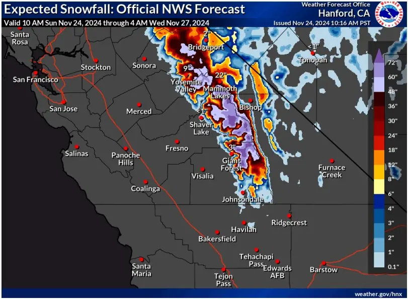
- Central and Southern Sierra Nevada are forecast to receive 76 – 152 mm (3 – 6 inches) of precipitation. The Sierra Foothills, San Joaquin Valley, and Central California Coast Ranges may see 25 – 102 mm (1 – 4 inches).
- At elevations above 2 130 m (7 000 feet) in the Sierra Nevada, snow totals could reach 30 – 150 cm (1 – 5 feet), with the heaviest amounts expected near Yosemite and Sequoia National Parks. Further inland, central Utah and west-central Colorado are forecast to receive 30 – 90 cm (1 – 3 feet) of snow in higher terrains.
- The NWS Weather Prediction Center has issued a marginal risk (≥ 5%) for rainfall exceeding flash flood thresholds in parts of Central California from November 25 to November 27.
- Major-to-extreme winter storm impacts are expected in the Central and Southern Sierra Nevada, where the NWS has issued Winter Storm Warnings. Moderate-to-major winter storm impacts are expected over the higher terrain in central Utah and west-central Colorado.
California is bracing for another atmospheric river (AR) system, which is expected to deliver substantial precipitation and heavy snow to central and southern parts of the state early this week. The event follows closely behind a previous AR and is anticipated to interact with subtropical moisture, bringing severe weather conditions to affected areas.
The National Weather Service (NWS) forecasts 76 – 152 mm (3 – 6 inches) of precipitation in the Central and Southern Sierra Nevada by Wednesday, November 27.
The Sierra Foothills, San Joaquin Valley, and Central California Coast Ranges are expected to receive 25 – 102 mm (1 – 4 inches).
These rainfall amounts raise concerns about flash flooding, with the NWS Weather Prediction Center issuing a marginal risk (≥ 5%) of rainfall exceeding flash flood thresholds for several regions.
Above 2 130 m (7 000 feet) in the Central and Southern Sierra Nevada, snowfall is expected to reach 30 – 150 cm (1 – 5 feet), with the highest accumulations likely near Yosemite and Sequoia National Parks.
The AR will also penetrate inland, contributing to significant snowfall of 30 – 90 cm (1 – 3 feet) in central Utah and west-central Colorado.

Winter Storm Warnings have been issued for the Central and Southern Sierra Nevada, where major-to-extreme winter storm impacts are anticipated. Higher terrain in Utah and Colorado is forecast to experience moderate-to-major storm impacts, with hazardous travel conditions likely in these areas.
The system is forecast to bring prolonged AR conditions to California, with San Luis Obispo County expected to experience AR 3 conditions for more than 48 hours, according to the Ralph et al. 2019 AR scale. Coastal Southern California may see AR 2 conditions persisting for over 72 hours.
Residents in affected areas are advised to stay informed through official NWS forecasts and warnings, available at weather.gov, and follow the instructions of local emergency management authorities. Travel disruptions, hazardous road conditions, and localized flooding are expected throughout the week.
The upcoming atmospheric river (AR) event arrives shortly after a previous system that caused significant damage across the U.S. West Coast. The earlier AR brought record rainfall and triggered 20 landslides in California, resulting in four fatalities.
In Northern California, two individuals were found dead in floodwaters amid the heavy rains. One man died after attempting to drive through a flooded road.
The storm also led to widespread power outages, with more than 1.5 million residents left without electricity.
The Pacific Northwest experienced similar challenges, with the atmospheric river causing hazardous road conditions and prompting flood and wind alerts. Wind gusts reached up to 105 km/h (65 mph), increasing the risks of flooding and mudslides.
References:
1 Quick Look at Atmospheric River Forecast to Impact California Early This Week – CW3E – November 24, 2024
I'm a dedicated researcher, journalist, and editor at The Watchers. With over 20 years of experience in the media industry, I specialize in hard science news, focusing on extreme weather, seismic and volcanic activity, space weather, and astronomy, including near-Earth objects and planetary defense strategies. You can reach me at teo /at/ watchers.news.
Commenting rules and guidelines
We value the thoughts and opinions of our readers and welcome healthy discussions on our website. In order to maintain a respectful and positive community, we ask that all commenters follow these rules.