
Large noctilucent clouds outbreak over Europe
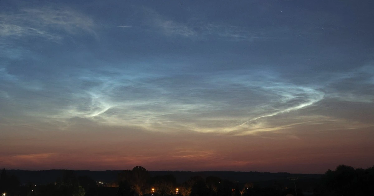
Image credit: Ujvárosi Beáta. Captured on July 13, 2024 at Vácrátót, Hungary
The display of unusual noctilucent clouds (NLCs) continues to light up the European skies on July 13, 2024, with another large outbreak seen all over the continent, leading to some stunning visuals.
A huge outbreak of NLCs was seen over Europe on July 13, following the previous appearances of NLCs that occurred in June.
Today’s outbreak was observed in many parts of Europe, including Hungary, France, Finland, and Norway.
A stunning view of the clouds was captured by an X user in Belfast at 03:30 local time (LT):
A stunning display of Noctilucent clouds
— Paul J McFarland (@PicturskewPhoto) July 13, 2024
Over #Belfast at 3:30 am @WeatherCee @angie_weather @barrabest @LoveBallymena @annlizkelly @GillMid1 pic.twitter.com/PoK7v1qVGo
“There were NLCs all around the sky!” said Ujvárosi Beáta of Vácrátót, Hungary, “This is really rare at our latitude (+47N),” she added.
HUGE OUTBREAK OF NLCS: European observers are reporting a "huge outbreak" of noctilucent clouds (NLCs) on July 13th. "There were NLCs all around the sky!" says Ujvárosi Beáta of Vácrátót, Hungary: pic.twitter.com/YMxI0jAdFH
— The Watchmen Earth and Space Connection (@TWESC2023) July 13, 2024
Here are some images posted by a user from Riga, Latvia:
Pagājušā naktī Rīgā bija fantastiski sudrabainie mākoņi! Sakumā tie parādījās ļoti agri DR pusē, bet pēc tam viss sākās uz Z-ZR. Vienā brīdī pat nevarēju izvēlēties, kuru pusi bildēt. 😀#NoctilucentClouds #sudrabainiemākoņi @StarSpaceLV @meteolapa @LVGMC_Meteo pic.twitter.com/rNiUYZ4Mjt
— Viktors (@wikt0rrs) July 13, 2024
The display of these NLCs is unusual in 2024 as the high solar activity due to the solar maximum is supposed to disrupt the formation of noctilucent clouds in the upper atmosphere. These displays have been continuing since June when the clouds were sighted all over Europe including Paris and Moscow.
No conclusive reasons have been found regarding why we are seeing these displays.
The two prevalent theories suggest that it could be either because of the undersea explosion of the Tonga volcano in 2022 or it could be due to huge amounts of water released into the atmosphere due to the combustion of rocket fuel.
References:
1 Huge NLC outbreak – SpaceWeather – July 13, 2024

Rishav Kothari is Editor-in-Chief of The Watchers, where he runs the newsroom and covers earthquakes, volcanoes, severe weather and space weather.
Earlier reporting
Nothing on Watchers was published in the last 24 hours. These are older articles.
- On October 22, 2017, a single flash of lightning stretched 515 miles from eastern Texas to near Kansas City, a distance that takes eight hours to drive, and nobody realized how far it had gone until scientists went back through the satellite data years later Epicenter
- CPC posts a slight risk of heavy rain from the Gulf Coast to the Northeast urban corridor November 25-29, and a moderate risk of West Coast wind and Sierra snow on November 25
- Florida's east coast faces a moderate flash flood risk Wednesday through Friday, with 4 to 8 inches of rain forecast and the St. Johns River near Cocoa already in major flood at 17.13 feet
- Cyclone Akvan to make landfall between Nellore and Visakhapatnam around noon on November 20, IMD forecasts 120-130 km/h winds gusting to 145
