
Potent storm threatens U.S. with widespread winter hazards
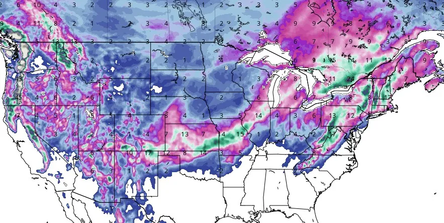
Featured image: Total snowfall in inches (January 3 - 11, 2024). Credit: GFS, TropicalTidbits
A powerful storm is anticipated to strike the eastern U.S. early next week, posing a range of winter weather impacts including snow, flooding rain, and damaging wind. The storm will form in the Rockies on Monday, intensify over the Plains, and peak from the Southeast to the Great Lakes and Northeast by mid-week.
The eastern half of the U.S. is preparing for another significant weather event following this weekend’s nor’easter. AccuWeather meteorologists say the new storm will deliver the first big snowfall along the Interstate 95 corridor in nearly two years.
According to the FOX Forecast Center, a potent storm is expected to form in the Rockies on Monday, January 8, 2024, and rapidly intensify as it moves toward the Plains. By Tuesday and Wednesday, it’s predicted to reach its peak intensity, affecting a broad swath of the country from the Southeast through the Great Lakes to the Northeast.
Meteorologists have been discussing a pattern change since the end of 2023, and it seems the upcoming storm is set to be a stark verification of those forecasts.
❄️ A winter storm will likely impact much of the East Coast this weekend, from the southern Appalachians through the Mid-Atlantic into the Northeast. Many details will be sorted out over the next couple of days. Stay aware of the latest forecast changes at https://t.co/pGx1JRZLBI pic.twitter.com/ciPQ2AWj2m
— NWS Weather Prediction Center (@NWSWPC) January 3, 2024
We're continuing to see the snowfall boundary just west of D.C. and NYC with upcoming weekend storm system = scant accumulation ❄️
— Ryan Maue (@RyanMaue) January 3, 2024
But there's still good news, Boston will get plowed 📈 pic.twitter.com/KdnCwDNh5U
The storm’s trajectory indicates heavy snowfall across the central Plains on Monday, moving towards the Great Lakes by Tuesday. Cities like Chicago, Kansas City, and Detroit are particularly advised to monitor the situation closely due to the potential for significant snow impacts.
The weather scenario is complex, with multiple inches of rain expected to fall from the Southeast to the Northeast as warmer southerly winds keep these regions too warm for snow. However, the areas that receive the most snow from the weekend’s nor’easter could face flooding as heavy rain falls on top of rapidly melting snow.
Severe weather is also a significant concern, particularly near the Gulf Coast. The FOX Forecast Center warns of impressively strong wind shear, supporting the potential for severe thunderstorms on Monday.
The Storm Prediction Center has already issued a Level 2 out of 5 risk for severe weather over parts of coastal East Texas into Louisiana, southern Mississippi and Alabama, and the western Florida Panhandle. Supercells and lines of storms capable of producing both tornadoes and damaging winds appear possible, with the threat potentially continuing east on Tuesday.
The storm’s size and low pressure are expected to create a large wind field, capable of producing damaging gusts from the Plains to the Eastern Seaboard, particularly across the Northeast where the winds will be strongest. These gusts could lead to significant power outages on Tuesday and Wednesday.
“This winter season so far, snowfall compared to the 15-year average has been below normal in most places. This could change over the next week or two, with a few upcoming snowy storm systems likely for parts of the Lower 48,” NWS WPC said.
Residents are advised to prepare for a range of winter weather impacts and stay updated with the latest forecasts.
References:
1 Another major winter storm looms for eastern US after weekend nor’easter – FOX Weather – January 3, 2024
2 Nor’easter to dump first significant snow in two years across East Coast cities – AccuWeather – January 3, 2024
The Watchers team and our contributors bring the latest on extreme weather, earthquakes, volcanic eruptions, space weather, and all things science. We're all about making sense of the natural world and keeping you informed on what’s happening. Got a tip or a question? Hit us up using the form at newstips!
What’s it look like for Kentucky ?