
Flood Watches issued as repeated thunderstorms raise flash flood concerns across the southern U.S.
The National Weather Service (NWS) warned that repeated thunderstorms capable of producing torrential rainfall may trigger flash flooding across parts of the Southeast and Gulf Coast this week, starting on May 25, 2026.
WPC Excessive Rainfall Outlook issued on May 25, 2026. Credit: NWS/WPC
Flood Watches remained in effect across parts of the southern United States on May 25, as repeated rounds of thunderstorms continued to raise concerns over flash flooding and severe weather through midweek.
NWS warned that clusters of storms capable of producing torrential rainfall may lead to scattered flash flooding, particularly in urban areas and locations with poor drainage.
The NWS Weather Prediction Center (WPC) said a series of upper-level disturbances interacting with a stalled frontal boundary stretching from the Lower Mississippi Valley into the southern Mid-Atlantic will continue supporting widespread showers and thunderstorms over much of the region during the next several days. Along and south of the boundary, a very warm, humid, and unstable air mass is expected to maintain favorable conditions for heavy rainfall through at least midweek.
A Slight Risk (Level 2/4) of excessive rainfall remained in effect across much of the Southeast and central Gulf Coast through the evening of May 25, while the flash flood threat is forecast to expand westward into parts of Texas on May 26.
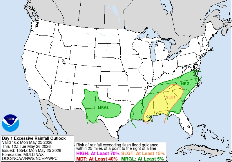
In addition to the flooding threat, severe thunderstorms capable of producing large hail, damaging winds, and isolated tornadoes are possible, particularly across parts of southwestern Texas.
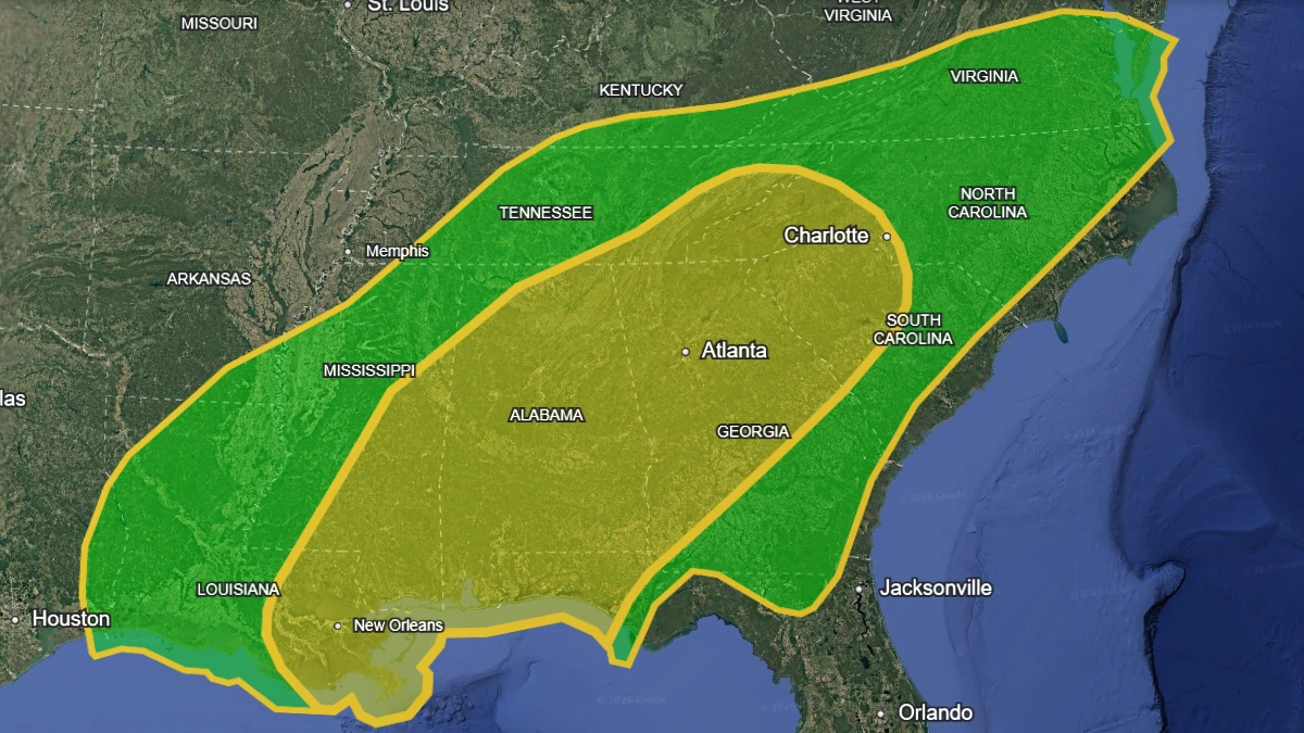
In Georgia, the NWS office in Peachtree City issued a Flood Watch through the evening of May 26 for portions of north central, northeast, northwest, and west central Georgia, including the Atlanta metropolitan area, as well as Gainesville, Marietta, Dalton, Rome, Carrollton, Woodstock, Dallas, and surrounding communities.
The Flood Watch, issued at 13:13 EDT (17:13 UTC) on May 25, warns that excessive runoff may result in flooding of rivers, creeks, streams, and other low-lying and flood-prone locations. Flooding may also occur in poor drainage and urban areas.
Forecasters said multiple rounds of rainfall are expected to move across the area through late May 26 as an anomalously moist environment persists over north Georgia. Rainfall rates exceeding 51 mm (2 inches) per hour may occur in stronger thunderstorms, increasing the potential for flash flooding. The NWS also warned that showers and thunderstorms may repeatedly train over the same locations, especially in urban areas and along creeks and streams prone to flash flooding.
In Alabama, the NWS office in Birmingham extended a Flood Watch through the evening of May 26 for portions of central Alabama, including Birmingham, Tuscaloosa, Montgomery, Gadsden, Selma, Clanton, Hoover, Talladega, and surrounding areas.
The Alabama Flood Watch, issued at 12:07 CDT (17:07 UTC) on May 25, states that flash flooding caused by excessive rainfall continues to be possible across the watch area. The NWS warned that excessive runoff may result in flooding of rivers, creeks, streams, and other low-lying and flood-prone locations.
The current atmospheric pattern is typical of late spring across the southern United States, when slow-moving frontal systems interacting with deep Gulf moisture frequently produce widespread thunderstorms and heavy rainfall events. However, the persistence of the current pattern increases the risk of repeated rainfall over the same locations and cumulative flooding impacts.
Forecasters expect the heavy rain and thunderstorm threat to continue through at least midweek, with additional flood watches or warnings possible as conditions evolve. Residents in flood-prone areas are advised to closely monitor forecasts and avoid driving across flooded roadways.

I am an Assistant Editor and Severe Weather & Science Journalist at The Watchers, specializing in real-time severe weather coverage, geophysical event reporting, and research-driven scientific analysis. You can reach me at rishav(at)watchers(.)news.
Commenting rules and guidelines
We value the thoughts and opinions of our readers and welcome healthy discussions on our website. In order to maintain a respectful and positive community, we ask that all commenters follow these rules.