
Powerful storm system tracks up the eastern seaboard this weekend, U.S.
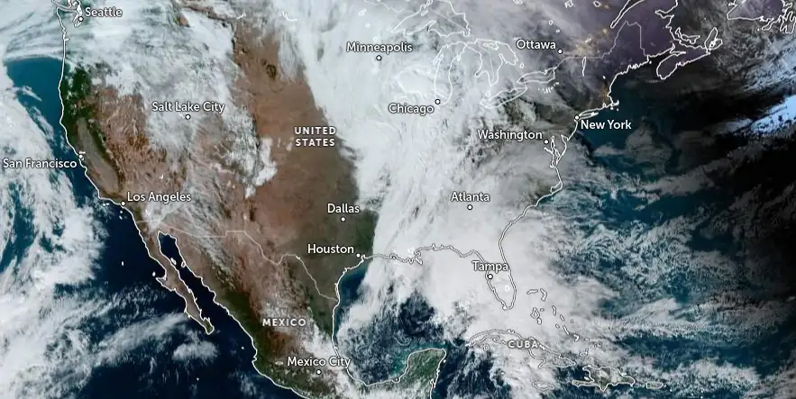
Image credit: NOAA/GOES, Zoom Earth, The Watchers. Acquired at 19:50 UTC on December 16, 2023
A strong storm system tracking up the Eastern Seaboard this weekend is expected to bring heavy rain, strong winds, and thunderstorms, with a Slight Risk of excessive rainfall issued for parts of the Mid-Atlantic into New England.
The East Coast of the United States is bracing for a strong storm system that will impact the region for the remainder of the weekend. According to NWS forecaster Ziegenfelder, the storm, which is currently moving onshore over the northeastern portion of the Gulf Coast of Florida, is expected to rapidly deepen as it moves northeastward to the southern Mid-Atlantic Coast by Sunday evening, December 17, 2023.
This major weather system is poised to produce showers and thunderstorms from the southern Mid-Atlantic Coast northward to New England.
The Weather Prediction Center (WPC) has issued a Slight Risk of excessive rainfall over parts of the Mid-Atlantic into New England through Monday morning. Heavy rain from this system is likely to cause localized flash flooding, especially in urban areas, roads, and near small streams.
In addition to heavy rainfall, the storm will also generate severe thunderstorms over the southern Mid-Atlantic Coast. The Storm Prediction Center (SPC) has issued a Slight Risk of severe thunderstorms through Monday morning for parts of eastern North Carolina and the eastern South Carolina Coast. The primary threats from these thunderstorms include frequent lightning, severe thunderstorm wind gusts, a few tornadoes, and minimal hail risk.
“This system will have the look and feel of a tropical storm as it races quickly northward from Sunday to Monday,” AccuWeather Chief On-Air Meteorologist Bernie Rayno said. “Weather enthusiasts along the East Coast with home weather stations equipped with barometers will be able to watch the atmospheric pressure fall quickly — an indication of the vigor behind the coastal storm.”
As the storm moves northward into Eastern Canada by Monday evening, December 18, the threat of excessive rainfall will shift to Northern New England. The WPC has continued its Slight Risk of excessive rainfall warning for parts of Northern New England from Monday through Tuesday morning.
Meanwhile, upper-level energy over the Great Lakes and Ohio Valley is expected to produce light to moderate snow over parts of the Upper Mississippi Valley and moderate to heavy snow over the western portion of the Upper Peninsula of Michigan from Sunday evening into Monday. Lake-effect snow will develop downwind of the Great Lakes, and upslope snow is expected over parts of the Northern/Central Appalachians on Monday into Tuesday. The heaviest snowfall is anticipated over parts of the Central Appalachians.
On the West Coast, a front moving onshore on Monday will bring rain to parts of the Pacific Northwest and the California Coast from Monday into Tuesday morning.
References:
1 Short Range Forecast Discussion – NWS Weather Prediction Center College Park MD – 311 AM EST Sun Dec 17 2023
2 Powerhouse storm to rock Northeast, snarl holiday travel a week before Christmas – AccuWeather – December 16, 2023
I'm a dedicated researcher, journalist, and editor at The Watchers. With over 20 years of experience in the media industry, I specialize in hard science news, focusing on extreme weather, seismic and volcanic activity, space weather, and astronomy, including near-Earth objects and planetary defense strategies. You can reach me at teo /at/ watchers.news.
Commenting rules and guidelines
We value the thoughts and opinions of our readers and welcome healthy discussions on our website. In order to maintain a respectful and positive community, we ask that all commenters follow these rules.