
Coastal low pressure to develop into major nor’easter with heavy snowfall and strong winds, U.S.
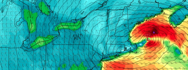
Image credit: GFS/TropicalTidbits
Residents along the northeastern United States are being urged to brace themselves for a major Nor’easter that is set to impact the region beginning late Monday, March 13, 2023, through Wednesday. The coastal low-pressure system is predicted to strengthen rapidly overnight on Monday and will have significant impacts on the Northeastern region.
- A coastal low pressure will strengthen rapidly into a major nor’easter that significantly impacts the Northeast Monday evening through Wednesday. The peak of the storm is expected tonight through Tuesday night.
- Heavy snow rates between 5 and 7.5 cm (2 – 3 inches) per hour, and strong winds will produce dangerous to impossible travel. The heavy-wet nature of the snow strong winds will result in scattered to widespread power outages and tree damage.
- Widespread minor coastal flooding and beach erosion may be possible tonight through Wednesday as the storm stalls and deepens off the coast of New England
- The impact of the storm is expected to be felt from Monday night through Wednesday. Residents are urged to stay vigilant and be prepared for any eventualities.
According to the National Weather Service (NWS), heavy snow rates, with some areas experiencing more than 5 cm (2 inches) of snow per hour, along with strong winds, will result in dangerous to impossible travel conditions.
The heavy and wet nature of the snow, combined with maximum wind gusts of up to 80 km/h (50 mph), could also result in scattered to widespread power outages and tree damage.
The impact of this Nor’easter could also be felt along the I-95 corridor from New York City to Boston.
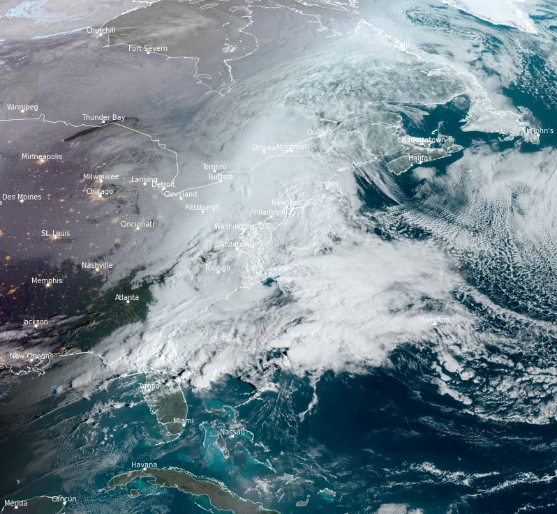
March Nor’easters tend to favor elevated terrain, which means that the heaviest snowfall totals are expected in the Catskills and southern Adirondacks in New York State, the Berkshires and Worcester Hills in Massachusetts, the Monadnocks and White Mountains in New Hampshire, and the southern Green Mountains in Vermont. Some areas could receive localized maximum totals of 60 – 75 cm (24 – 30 inches) of snow.
Furthermore, meteorologists warn that the low pressure could stall and deepen off the coast of New England, leading to widespread minor coastal flooding and beach erosion that could last until Wednesday, March 15.
This Nor’easter is expected to bring significant disruptions to daily life, and residents are being advised to take precautions and stay tuned to weather updates. Travel should be avoided where possible, and residents are encouraged to stock up on essential supplies in case of power outages or road closures.
References:
1 Short Range Forecast Discussion – NWS Weather Prediction Center College Park MD – 342 AM EDT Mon March 13, 2023
I'm a dedicated researcher, journalist, and editor at The Watchers. With over 20 years of experience in the media industry, I specialize in hard science news, focusing on extreme weather, seismic and volcanic activity, space weather, and astronomy, including near-Earth objects and planetary defense strategies. You can reach me at teo /at/ watchers.news.
Commenting rules and guidelines
We value the thoughts and opinions of our readers and welcome healthy discussions on our website. In order to maintain a respectful and positive community, we ask that all commenters follow these rules.