
Multi-hazard storm moves into the Plains, U.S.
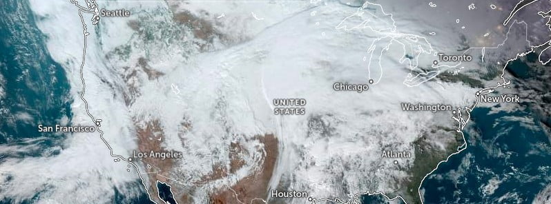
Image credit: NOAA/GOES-East, Zoom Earth, The Watchers. Acquired at 20:50 UTC on January 2, 2023
A multi-hazard storm will bring a swath of heavy snow, sleet, and ice in the north and central Plains and Upper Midwest during the next couple of days, the National Weather Service (NWS) warns. Across the Arklatex region and into the Mid-South, severe storms with all hazards and heavy to excessive rain can be expected, with the primary severe threats of tornadoes, some strong, and damaging winds.
A low pressure system currently developing over the central High Plains will become the latest winter storm to impact areas from the northern to central High Plains through the upper Midwest during the next couple of days, NWS forecaster Kong noted.1
A swath of moderate to heavy snow is forecast across the northern half of this general area where highest snowfall amounts could exceed 45 cm (18 inches).
Meanwhile, a swath of freezing rain and mixed precipitation is expected across the southern half of this area where the highest ice accretion can exceed 6 mm (0.25 inches).
Winds are expected to increase as the low pressure center tracks across as well but they are not expected to be excessively strong as the main energy associated with the system is forecast to be sheared to the east, leading to a gradual weakening of the storm by Tuesday night, January 3.
Nevertheless, heavy snow and gusty winds will result in reduced visibility and difficult to hazardous travel conditions in snow-covered roads across the central to northern Plains as the storm intensifies tonight into Tuesday.
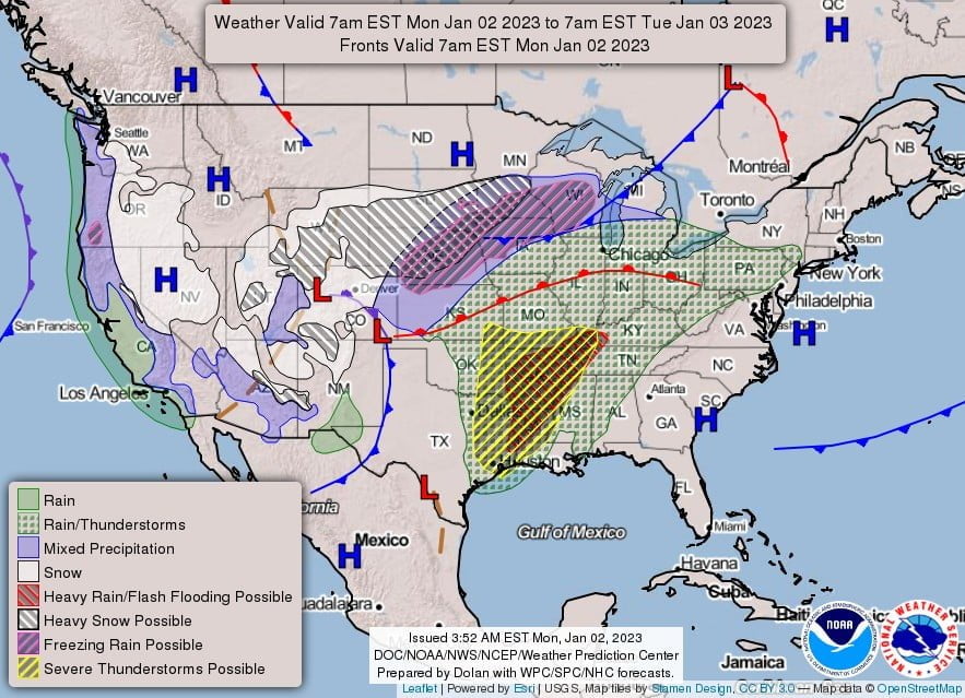
Meanwhile, heavy rain and severe weather will continue to be the main story across the mid-South through tonight ahead of a strong cold front trailing south from the intensifying low pressure system.
The hazards associated with these thunderstorms are frequent lightning, severe thunderstorm wind gusts, hail, and a few tornadoes.
There will also be an increased threat of EF2 – EF5 tornados over the region.
By Tuesday, the heavy rain and severe weather threats will shift progressively east into the eastern Gulf Coast states and perhaps farther inland toward the Tennessee Valley as the cold front pushes eastward.
These threats are expected to be slightly lessened on Tuesday.
In the meantime, wet weather will spread northeast into New England on Tuesday with mixed precipitation possible over northern Maine.
By Wednesday, January 4, much of the East Coast will be under a good chance of showers and thunderstorms but areas west of the Appalachians will see rapidly improving weather behind the cold front.
References:
1 Short Range Forecast Discussion – NWS Weather Prediction Center College Park MD – 300 PM EST Mon Jan 02 2023
I'm a dedicated researcher, journalist, and editor at The Watchers. With over 20 years of experience in the media industry, I specialize in hard science news, focusing on extreme weather, seismic and volcanic activity, space weather, and astronomy, including near-Earth objects and planetary defense strategies. You can reach me at teo /at/ watchers.news.
Commenting rules and guidelines
We value the thoughts and opinions of our readers and welcome healthy discussions on our website. In order to maintain a respectful and positive community, we ask that all commenters follow these rules.